Say you have a natural area, that users generally regard as one “place” (e.g., there’s hiking trail’s throughout and/or there’s no discernable borders when you navigate around), but on OSM it is represented as several parcels (tags landuse: conservation and leisure: nature_reserve) because they have different property ownership. I’ve included links to two polygons that are adjacent as examples:
In the area of these polygons are a series of natural areas owned by the local town, the state department of Fish and Game, and the US Department of the Interior. The OSM polygons have useful meta-data, of course about ownership, but also about when the areas were protected, maybe websites to the relevant land managers. From a user perspective, the protected area (solid green outline) is just a helpful indicator of where to hike (following trails, etc.), but the multiple names for each polygon showing up seems distracting and unhelpful (in addition to the jigsaw puzzle of protected area boundaries crossing the map). What would be the best approach for this area, to create something “cleaner” looking from a user standpoint. Is there a responsibility to preserve the meta-data on parcel ownership if multiple stakeholders are contributing to the conservation of this [largely contiguous] natural area?
This depends on the situation. There certainly are conservation areas made up of parcels owned by different organizations, but with a collective management plan and name. In a case like that I’d say merging the boundaries for simplicity can make sense. OSM does not aim to be a parcel map, so there’s not a good reason to map the parcels separately. However, this does not mean all adjacent conservation areas with similar names should be merged! A wildlife management area operated by a department of fish and game may well have a different management plan and different regulations from a neighboring recreation area operated by a different organization. Hunting may be allowed in one, but not in the other for example. So I would advise caution and only merge parcels that you know are truly are managed as a joint venture.
It is also possible to render a cleaner looking map, even with the various adjacent polygons mapped separately. A data consumer could merge adjacent polygons before rendering and omit the names so they are just shown as general conservation land.
The problem with these & numerous other polygons in MA is that they are imports from the MASSGIS system and probably reflect complex administrative histories of these areas (as you suggest) rather than on-the-ground reality. The data certainly needs cleaning up to be more like typical OSM mapping, but this has always seemed a huge task to me. I’m more familiar with the area around Yarmouth Port and Dennis, but I think the problems are similar in those locations tool.
The granularity of the data based on parcels may well be valuable, but it may also not be wholly appropriate for display on a more general purpose map such as the Carto-OSM one. Some judicious re-tagging might help a bit, particularly if it improved visibility of those areas most appropriate for leisure & recreation purposes.
There is also a generic OSM issue here, which is that we don’t have a good way to show that individual polygons make up a whole (e.g., analogous to building:part): 'e.g.*, a single wood made of areas of different kinds of trees, a single swamp with areas of different protected status, etc.
There is also a generic OSM issue here, which is that we don’t have a good way to show that individual polygons make up a whole (e.g., analogous to building:part): 'e.g.*, a single wood made of areas of different kinds of trees, a single swamp with areas of different protected status, etc.
you can have a wetland and have nature reserves or protected areas overlapping it, no problem.
We cannot express (with common established tags) different landuse or landcover / mixes of these with a common name, I generally agree with your statement, but the wetland example would be working with common tagging
I generally for the most part work off if they are managed together or if they have different rules. I guess some examples of what I have done.
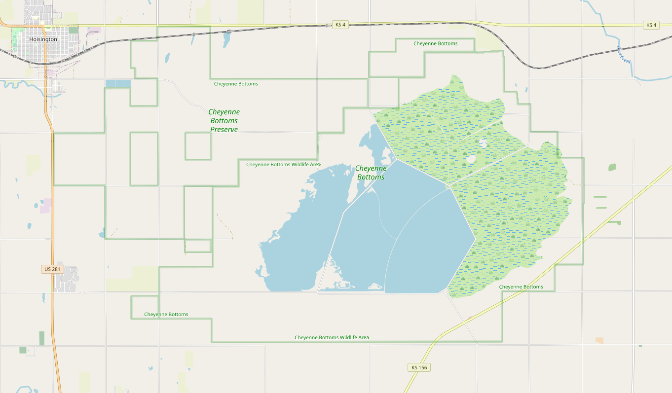
The Nature Conservancy owns 8000 acres as a preserve next to area managed by the Kansas Department of Wildlife, these are under different management with different rules. The TNC do not permit hunting where your permitted to shoot birds on the Kansas owned land. So different ownership and rules to me means mapping separate.
Konza Prairie, this south western portion is owned by K-State instead of the The Nature Conservancy, but The Nature Conservancy hands management over to K-State, technically different owners of the land, but K-State manages both under the same rules its private except for the hiking trails. There is a further northern portion connected, but it is purely an easement on private property, so despite it being included in some maps I don’t map private easements.
Link because I am limited to 1 image per post
I generally just try to follow what other people are doing or what seems reasonable this is generally my rules of thumb on it.
What I am less sure and did longer ago, but the Army Corps of Engineers own the whole land that is the recreation area, and within it some parts are managed by the State that is the Tuttle Creek Wildlife Area, those actually overlap that might not be the most correct but seemed the best way to handle it at the time, then we have the State Park i have them separate for no other then the signage on the ground gives them two different names, though those could probably be conjoined they are under the same management and i generally the same rules.
So with the example of hunting, is there a tagging system that denotes some land as hunting (with subsequent rules, restrictions), versus other land as absolutely no hunting? How would OSM users know? My assumption is that hunters would have to know that (in your example) Cheyenne Bottoms Preserve has hunting allowed, and so they would be user their phone to stay within that boundary. So in that way, the green preserve boundary on the map is helpful.
So with the example of hunting, is there a tagging system that denotes some land as hunting (with subsequent rules, restrictions), versus other land as absolutely no hunting?
Hunting regulations are so complex and different by state and by area it would be hard to express that fully in tags, I think the big thing is just showing they are different areas, and maybe some quick info, I always do my best to link to State Websites about the location and they have that information. Much in the same way we don’t tag roads with every local areas driving regulations, we don’t need full hunting information, here we have to take a class and take a test on rules and regulations to be able to hunt in Kansas. So the hunter should be aware they might mostly be using maps just to see what area is which.
@raisinsfried that’s a fantastic summary. Yes a hunter should be aware of their local regs, and they should know where they can hunt. They may have a paper or other digital map but if OSM has at least a helpful line distinguishing areas, that benefits them. I can imagine another use-case, where one preserved area has lots of hiking, but an adjacent parcel is preserved for nature only (no hiking). Keeping the two polygons as separate protected areas helps there.
Can a relation be used to join the disconnected parcels together? I agree the sort of individual parcel import data is not always intuitive in areas where the boundary is purely administrative rather than to do anything with the management of the land.
I have done a LOT of clean-up in MA of that MassGIS OpenSpace layer import from a decade ago. As someone already pointed out, the data was based on tax parcels so many large properties were broken up. Most of my work has been combining and realigning property boundaries to the latest MassGIS parcel data available. (Much of the old OpenSpace layer was poorly aligned, especially the further west you go.) In cases like the example you mentioned, I’d still combine but leave ownership off. If I’m feeling particularly motivated, I’ll create sub-boundaries to add ownership detail, but NOT apply the nature_reserve tag again.
If you’d like to chat or collab further, give me a DM here or OSM Slack. I’m a bit less active lately, but I’ve spent many, many hours all over the state mapping “public” lands.