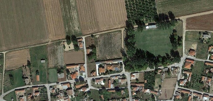
Where exactly? If you are talking about the horizontal road towards the left, I would put it unclassified and with surface dirt (it looks like dirt from up here). Unclassified because it looks like no house is facing at that road. Maybe others have a better opinion for such cases because really near a residential area (I’ve seen many times people swapping such roads between unclassified and residential).
Track roads are mainly used for access in agricultural lands. Should not be used for all dirt roads. That’s where the surface tag comes.
Nevertheless, if I were you, I’d specify it as ‘track’.
Of course, I think most of us would agree that it’s hard to make a clean cut on what is and isn’t a track.
However, even if there is a private house that exists apart from the village, if the path was originally intended as a farm road, or still has that primary purpose, I think it’s a good idea to designate it as a ‘track’.
Oh, of course, if a private house alongside a farm road is already clustered, that might be different…
Here again, I think it is more important what the original purpose or main purpose is rather than whether it is a paved road or an unpaved road.
And, at least on the surface, the top left and top roads don’t look like the roads given the house.
This raises the question whether the road type describes the look of a road, for example whether there are houses, or whether it describes who travels over that road. I prefer the latter as roads are related to traffic.
Bear in mind that highway=track can be ambiguous with regards to access, whereas highway=residential or highway=unclassified has an expectation of public access. If you use highway=track, make sure to add access tags explaining who is allowed to pass along.
This raises the question whether the road type describes the look of a road, for example whether there are houses, or whether it describes who travels over that road.
if there are houses then it will rarely be a track because the purpose of the road will be providing access to the houses, their residents and visitors, postmen and delivery services, etc. and not just fields and forests
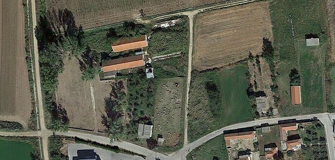
What if there are two houses along a dirt road and that dirt road leads to fields? And what if there is another dirt road that connects two villages but there are no houses along it?
What if there are two houses along the dirt road and that dirt road leads to fields?
from that description, maybe up to the houses services and from there track?
And what if there is another dirt road that connects two villages but there are no houses along it?
could be highway= unclassified
Last question, what if there are houses in the middle of 2 dirt roads and the houses are facing only one of the two dirt roads?
So generally, the road facing the houses would be the street and would be tagged as highway=residential, living_street or pedestrian.
However, if access to properties is not the main job of that road is not a street and then it would be tagged as highway=unclassified or higher.
Then add the fact that it is a dirt road with surface=dirt.
If the reason the road exist is for agricultural purposes than tag it with highway=track.
If the road behind the houses is only for the people there than tag it with highway=service.
In my opinion, it’s hard to use as a baseline.
Of course, it’s a matter of personal opinion or local information whether you see it as a track or a residential, but it’s hard to teach for the sole purpose of reaching that house.
As long as the house is inhabited, there will be many reasons to reach it, which leads to the contradiction that every pathroad to an inhabited house must be at least ‘residential’.
(Note that ‘path’ here does not refer to the value of the tag in the OSM; it just means ‘path’ in general.)
Only vehicle roads to inhabited places have to be at least service or residential, not paths. Paths are not usable by vehicles.
Classification of roads is done according to purpose not by surface.
There are even dirt roads classified as trunk when they are the only connection between larger cities.
Did you mean highway=footway?
Highway=path almost always implies bicycle=yes. In addition to this very often even motorcycles and other small motorized vehicles are allowed. In Europe often only up to 50 ccm but in Asia, Africa, Central- and South America it is common that there are no restrictions at all and every motorized vehicle that physically fits a path can legally use it.
No, on its own it just says “there is some sort of path here”. It does not say anything about access rights or suitability.
It may be that in some countries a “right to roam on bicycles” is a thing, but it is far from universal.
As pointed out already surface is irrelevant for road classifications in OSM. All that matters is function.
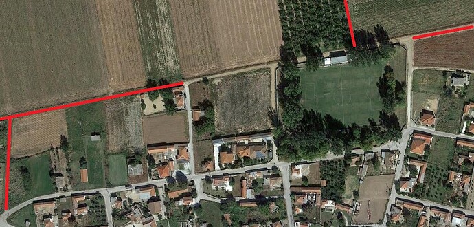
Looking at your screenshot it seems that all roads except the ones marked red are used to access houses which makes residential the appropriate classification.
The red ones could be tracks (except if they are used by cars to access houses not visible in screenshot).
May be a thing in some countries? That seems like a blatant understatement.
According to the documented default access restrictions bicycle=yes is the global default. Additionally 30 of the 32 countries that specify national defaults also define it as bicycle=yes.
Considering country size bicycle=yes is the explicit default for roughly 2850 million people. Missing from the list, but quite certainly falling in this category too are India, Indonesia, Pakistan, Nigeria, Bangladesh, Mexico, Ethiopia and Vietnam. This means bicycle=yes default is applicable to at least 5450 million people or about 70% of the worlds population.
On the other hand bicycle=no is the documented default for only 9 million people (0.0011%) while 67 million people (0.0084%) enjoy a default of bicycle=maybe.
Even if we just guess to which side the 140+ remaining countries belong, I think it’s not a stretch to say that the “right to ride a bicycle on most paths that are physically suitable” is nearly universal with Austria and the UK being two very odd outliers.
Untagged access rights that are more restrictive than global/national default are a possibility on all OSM highway types, not just paths.
And the fact that highway=path is commonly used for ways that are exclusively suitable for walking is a long-standing and well-known problem.
That wiki page is utter (expletive) and always has been. To take the UK, where I am, as an example, there isn’t just one jurisdiction here, there are three, so having just one table makes no sense. “Where you can walk and cycle by default” in England and Wales (public bridleways and some other explicit rights of way) is very different to in Scotland (subject to the Scottish outdoor access code). It isn’t just the UK - in another thread on this forum a couple of days ago someone noted that a question was being asked about somewhere in Baden-Württemberg (in Germany) and his these issues apply.
If you genuinely think that you can make that calculation based on an OSM wiki page then I have a bridge for sale that you might be interested in.
![]()
Of your examples I only have experience of a couple of countries in Africa and my experience there was definitely NOT that “there are no restrictions at all and every motorized vehicle that physically fits a path can legally use it”.
The function of a road can evolve over time. We should not try to know what the way was originally intended for.
The image give us a quite restricted perspective over these roads. For the horizontal red line between the farmland and the settlement, I would indicate hignway=unclassified. For the vertical red way moving north from this highway, If only going to farmland area (the extremety of the network, not connecting to other roads), I would indicate highway=track.
According to anyone who tries to actually do bike routing with OSM data, assuming bicycle=yes on a bare highway=path is liable to get you routed over a cliff, through a 1m private alleyway and into a crocodile-infested swamp.


