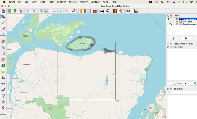
Should coastlines create a closed polygon? Please see the result of the overpass API below for the area contained within the square. Only part of the island Charapucu is tagged as coast. The rest seems to be tagged as non-coast waterways. These non-coast waterways connect with the coast and form a closed polygon, but it was my understanding that the coastlines should be able to create a closed polygon by themselves?
There is no clear line where a river ends and the ocean begins. But there are indicators of when something is more “inland water” or more “ocean”. What differentiates rivers from ocean is the flow of water and the salinity of the water, not universally, but pretty much so.
Generally you should draw the coastline across the river mouth at that place where you don’t see changes in water level due to the tides any more but only changes in water level due to more or less water coming from the river. That’s about the same definition as: inland waterways are where the water is not salty, and ocean is where the water is more or less salty. And yes, that’s fuzzy. And yes, that’s not easy to tell from a single overhead image. Use your best judgement.
Yes, islands in the sea are closed polygons with land on the left, sometimes multiple ways with natural=coastline for long coastlines. Islands in inland bodies of water should not be tagged with natural=coastline. Instead, they should be inner rings of their water areas.
The problem is that the coastline of south america is drawn somewhat arbitrarily across the Amazon delta, which makes the island in your picture incorrectly tagged since it’s “inland”.
Coastline is supposed to be mean springs, but tides in the Amazon delta are complicated. Do we have any prior discussion of coastlines in river deltas?
I assume you mean Ilha de Marajó not Charapucu. The coastline on the right is part of a closed polygon, that’s the one for South America. Have a look at this way that cuts across the river delta.
I am guessing it doesn’t show in your screenshot is because you took it after you removed the natural=coastline tag from this way, but I can see that you’ve re-added it already.
What doesn’t make much sense to me is that each of the ways making up Ilha Mexiana is tagged as both natural=coastline and as an inner to the river multipolygon. As a result there’s a coastline polygon (Mexiana) inside a coastline polygon (South America).
You can argue about how far up the river delta the coastline should go but it will have to cut across the river at some point. (See e.g. here for the Thames)
I would think that an island in the river that’s “above” the coastline is then tagged as an inland island (e.g. inner to the river delta) and one that’s below the coastline is tagged as an island in the sea (coastline), but I cannot think of a reason for a whole island to be tagged as both. (Marajó is a bit of an edge case where it’s partly one and partly the other, its northeastern part being part of the coastline for South America)
Yes, it seems it’s Ilha Mexiana that has me confused. Aren’t coastline ways directional, such that to the right of the way is the ocean (to the left is land)? This would create a discrepancy as Ilha Mexiana’s coast ways are saying the area next to the island is ocean, but Way: 551948655 | OpenStreetMap says it should be land. How do renderers reconcile these seemingly opposing facts?
