Hey! I am working on a community page that will show me OSM street segments that require a fresh set of Mapillary Images. Right now, this is “just” a visual page. However, I wonder how I could connect this to some (external) routing.
However, I am wondering if there is a community routing service out there, that I could link to from my website. For example by providing the streets in question as URL param.
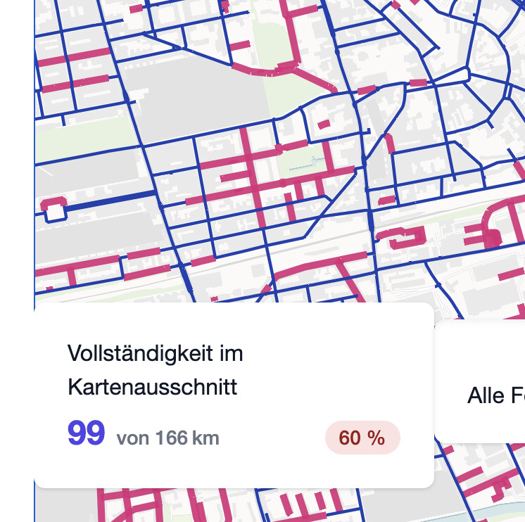
Here is a sneak peek of what the page will show:
(The pink segments require fresh Mapillary images. Those are the once that a router should put into the most efficient route for me…)
For your use you would have to export a list of waypoints with the middle of each “road” you want to finish, import those and create a route from the start to the endpoint passing through all the other given waypoints. Then chose Optimize and QMS will run s an approximation algorithm for solving this problem.
Yeah, in my limited optimization experience, this is a different problem than what that wretched Valhalla PR tried to solved. AFAIK the problem with these postman problems is that they need to have access to a graph, not only routing results as e.g. TSP, which is why we decided back then to incorporate it into Valhalla. Typically you’d like to avoid that with VRPs, see VROOM. But I’d suspect the same to be true for this rural one. FWIW, I’d like to clean up camptocamp’s mess of a PR, but it’s abysmally far down the priority list
I was looking at the very same issue a couple years back as i have the same issue, not just for revisiting but also for initial riding for mapillary.
I could find any “point and click solution” on a website. As the problem is NP hard (As was already mentioned) there can only be algorithmical estimations which must not necessarily be the best solution.
the issue i was thinking through is that in one ride i typically to 20-40km - so ist halve the distance (as i do all streets both way). So we are talking about 10-20km of highway/road/path segments.
Putting a small area like this into a graph an solving that by brute force should be doable pretty easy.
In the end it wasnt that of a needed solution as most of the time i segment citys by higher class road boundaries and mostly do the riding by brute force.
If you look for algorithms, check if they are for the “undirected” or “directed” variant.
Nice, you found the next harder problem Given the set of street segments to visit, find k tours such that none is longer than 40 km while minimizing the sum of tour lengths.
Hello, I can’t offer any help to automate the process of creating a route but personally I use Osmand.
I use the mapillary plugin to see the roads that have imagery. Then I plan a route directly in app, save it as a gpx trace that I then follow.
It takes a bit of time but it does mean I chose the route, especially useful as I don’t just go out to capture but take a detour when I am going somewhere.
The only real missing feature would be to filter on capture date, so as to capture again roads that were captured 5 years ago or more…
Maybe you could consider adding the ability to create a gpx route on your site and it will work the same?
Just to keep this thread updated with news, last year Reddit - The heart of the internet was posted so maybe this feature will come to Wandrer. Did anyone here something about that in the meantime?
Graphhoppers website does it to some extent, which is frustrating when it rearranges my vias when I am planning a walk as
a. I don’t want to turn around.
b. I want to visit in the order I specified.
c. If I’m planning a 10km walk I don’t need it to say hey you can visit those places in 7km.
The Chinese Postman is a variation of the classic traveling salesman (and much “easier” to solve, since there is no restriction to pass again in the same edge).
Very interested in any solution. I was planning to cover an entire area (suburb/city/whatever) to collect Mapillary imagery driving. The main thing I found was to integrate any algorithm with turn/way direction restrictions (you don’t kinda have this problem walking).
@seen-one AFAIK the thing I described initially is not solved by any of the current solutions. I am looking for a tool that helps to draft the best route with two inputs: First the whole road network, second a list of road segments that I need to drive along. The route should findet the best way to drive along all the road segments… using whole road network. Use Case: Plan routes for Mapillary update-tours.