(Scusa, scriverò in inglese, il mio italiano non è molto buono.)
I have just hiked along the VF from Piacenza to Fornovo and from Massa to Lucca. In some places the route appears to have changed, sometimes a lot. The signage is pretty new in most places, so I think OSM is less recent.
I could improve parts of the relation, but I have not checked everything. Our itinerary was sometimes very different, dependant on where we could find a place to stay for a night, and sometimes because we thought we could find a better route! I also do not want to get in the way of Italian route mappers who of course know Italian mapping habits better than I do.
Would you like me to have a go and map what I have surveyed?
I am pretty sure about the changes, but less sure that the old route is gone. Several times the main direction had new signs for the new section, but from the other side hikers were still (mis)guided to the old route. Also, old sections tended still to have the signage, just not maintained. The fact that there are several signing systems, which do not always agree, doesn’t help either. Still, I will do what I can.
(side note: water levels in all natural rivers and streams were incredibly low to non-existent! Still nature seemed to find enough water, and the system of canals and microcanals for irrigation of maize and sushi rice fields still provided enough water. Nederland could learn a lot from the Italian system! We are very good at pumping water away, but not so much at retaining water, which means we suffer much more from hot dry periods and low ground water levels.)
After the VF-sections we did the San Jacopo Cammino Toscane, from Lucca to Firenze. I have kept notes and made many snapshots, so I think I can improve lots of details there. One issue: The predominant symbol is not the Shell, but the orange and yellow paint stripes. Orange in one direction, Yellow in the oter direction. Only one of them (yellow, to Livorno) includes the shell, but not consistently. The other system, Arrow stickers and shields, also have yellow (and a pelegrino) and orange (and a Roman) for the directions, but these often rely on the painted signage in the absence of poles and the like. And there are also old stone markers… The point is, I don’t thinks the shell actually is the main symbol, I think the orange-over-white is the main symbol for this two-way route.
Also, the Cammino is international, but this route is tagged as regional. Is that correct?
I think that the “Cammino di San Jacopo” (Italian wikipedia page) is inspired by the more famous “Camino de Santiago” and uses the same route symbol but apart from some resemblances, it is in fact a completely separate pilgrimage.
I don’t think so. The St. Jacobspaths in al of Europe are the routes to Santiago de Compostela. They can start anywhere. In this case Firenze to Livorno has been chosen and waymarked, and the route back was waymarked as well with comparable but slightly different symbols and name.
I think this section is the regional section of an international route to Santiago. From Livorno you are supposed to take the ferry to Monaco, and continue there on the Via Aurelia which is a section of an international Jacobspath superroute.
The direftion Livorno-Firenze is truly regional, though, the shell symbol is not used in that direction, the colour of arrows and paint stripes is orange instead of yellow, and the shield/sticker variant of the signage shows a roman figure instead of a pilgrim. It took us a while to figure this out.
That said, both directions follow exactly the same ways. Having two separate relations with exactly the same route just because of the signage and the direction is overkill.
On e.g. waymarkedtrails the symbol now shows a yellow shell on a blue background, but the main signage for the two-way route is orange-over-yellow. I would suggest, if possible, to use orange upper and yellow lower, and add the regional route to an international superroute which has the commonly used international shell symbol.
On the map you will then see both symbols along the route, and it’s easy to see that the regional route has to be followed from Firenze to Livorno, because the shell symbol is not consistently used for local navigation.
I don’t know much about the “Camino de Santiago”, you may be right.
Wait for others to have their say and if nobody complains, I think you can do your edits based on what you have seen on the ground or on what you know.
P.S. there is no ferry ship between Monaco and Livorno
So true! Via Bastia you can get there, though. If I were a true pelegrino hiking to SdC, I would hike the entire coast through Liguria, and France. So, in Lucca I would take the Via Francigena (reverse) to Massa (or a bit further, La Prada or Portonetti), from there the Via Della Costa to Monaco. I am suprised that the Via Della Costa is not part of an international St Jacobs superroute, even though it has the shell as its symbol.
Between Lucca and Massa following the Via Francigena I didn’t come across the shell symbol, which is kind of surprising, but ther might be a completely different SdC Cammino route.
If not there’s simply a gap in the international Cammino route. Nederland is also a gap, because there is no systematic shell waymarking, and none of the many, many well maintained national hiking routes has been appointed as The Dutch SdC cammino section.
VF: I have processed my notes and snapshots. I made the changes I am reasonably sure of.
Via Jacopo Toscane was more difficult. Some changes I find in the paper guide were not clear on the road. Or the three signage methods differed, or the main direction differed from the opposite direction. Sometimes the route was changed officially, but the old signage was still there. I then chose what was most prominent (according to my best judgement) on the road as the main route in the section relation, and made a separate variant relation for the other piece.
I also made a variant if the paper guide gave only one route, but on the road a clear choice was offered to take another road to the next destination.
Now the international issue of the pelgrimage to Santiago. It appears Italy does not have a national plan for this Cammino, and only Toscana has decided to appoint this regional route as part of The Cammino. IMO that is no basis for entry in an international Cammino superroute, even if there was one that could serve as such. It’s just Firenze to Livorno, and in Livorno it’s “take a ferry and good luck!”.
A true pelegrino would not go to Livorno, but walk through Lucca and Massa, then take one of the many coastal paths to get to Monaco, where a waymarked Cammino leads all the way to Santiago.
So I think it is in fact a regional route divided into 6 local tappe, and a high degree of wishful thinking!
The main symbol for this via in Toscane is an orange-over-yellow flag symbol. Yellow is the pilgrimage direction; Orange is the opposite direction. Yellow is associated with the shell symbol and with a pilgrim figure; Orange is associated with a figure of a roman, suggesting it is the way to Rome.
What I did to cope with the symbols: I made the tappa relations local (network=lwn) and their osmc:symbol orange-over-yellow; and I left the superroute rwn and the symbol the international Cammino shell (yellow shell in blue background) as it already was. On waymarkedtrails it looks like this.
I think this reflects ground truth better than just the shell symbol, because you just can’t follow the route by the shell symbols alone. You often need the combination of paint markings and arrow stickers.
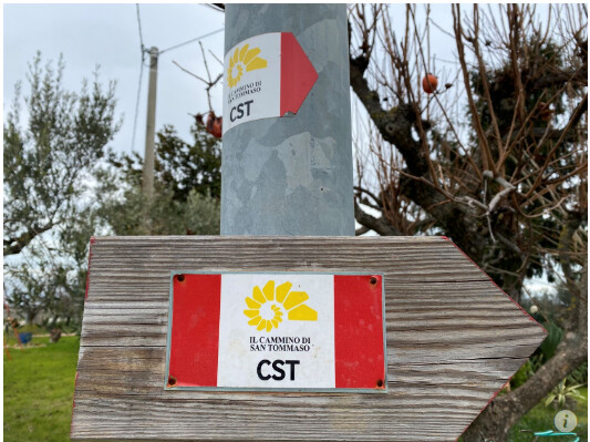
OT/ If ever someone fancies mapping another long walk and practice the trail from Rome, Lazio to Ortona, Abruzzo, then ‘Il Cammino di San Tommaso’, a mere 316km and 16 days the original walkabout took. Multiple sites such as 'Cammino di San Tommaso - Cammini d'Italia and even a dedicated society, I’ve mapped a few km only because it coincided with an old cycle track, which was redone this year and all the CST signs disappeared looking like
OT / I would like to, but first we decided to close a gap (VF from Fornovo across the Apennines to Massa) then move on to Viterbo (we already did Firenze to Viterbo) and finish our hike to Rome, after a mere 20 years. I’ll update OSM where I can, of course. Then…maybe! We absolutely love hiking in Italy (excepting most of the Po plain, sorry to say, because for flat hikes between rivers and dykes we can just step outside!). And we like the language.
Salve!
Abbiamo proseguito nel Lazio: Viterbo-Roma-Sezze. Ho visto cambiamenti sulla strada, ma la relazione del percorso dice: per favore, non cambiare. Ad esempio qui vicino Vetralla:
The red line is blocked, and all official and unofficial signs and waymarks point the peregrini as the blue line shows. I tracked it, and the track shows I truned back to double check the signage.
South of Roma, some stages have changed completely, I have taken photos to make sure how the waymarking is, and that it’s not a temporary alternative or a variant, but truly the new main route. I’ve doublechecked this with the VF app.
I can update the relation of course, but because of the “do not change” remark I could maybe better provide my data to someone who regularly maintains this relation.
I can update the relation of course, but because of the “do not change” remark I could maybe better provide my data to someone who regularly maintains this relation.
the relation should reflect the current situation on the ground, if you noticed differences while walking there you can (and should) of course update it (we are speaking about signposted/trailblazed ways, correct?)
Fixed the issues. Yes, the Via Francigena is heavily signposted, sometimes in five different styles together on the same spot. I still managed to miss some corners, though, and there are corners with conflicting clues. Ah, the adventure!
I noticed many roundabouts have been entered as an uncut circle in the hiking route relation.
This is fine from a routing standpoint, but route relations don’t need to be routed, because the operator already created the exact route and the mapper recorded that in the route relation.
For mapped-route data users it’s better to cut the roundabout circle and enter only the actually used sections into the route relations (including PT routes). I did in fact see a few sectioned roundabouts.
Is it common/necessary in Italy not to section roundabout circles, or is it a matter of the work/complexity involved?