I did a search relating to this and the only thing I really found was back in Dec 2018. It was suggested the issue may have been do to things not quite lining up in their map. Nothing posted since then.
The issue I am running into is with routing with BaseCamp when crossing the bridge at the border between Canada and the United States, it reroutes taking over 2,000 km which would only be just over 200 km. MapSource doesn’t appear to be having the same issue, I might know why. In BaseCamp you can select avoid Highway’s in MapSource there is a slider to select a preferrence.
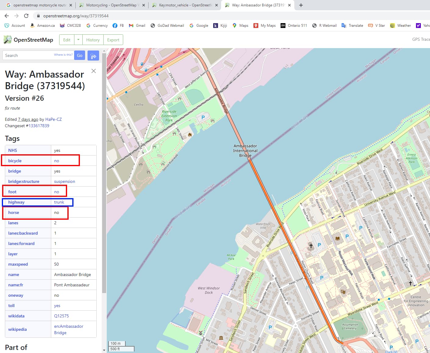
In checking the tags for the bridge it has for bicycle, foot and horse “no”, no mention of other vehicles which I can see.
For the Key Motor Vehicles has different permitted values including motorcycles. I have made some edits in OSM but being pretty new and not wanting to screw things up I didn’t want to make any changes that could / would vastly affect things (I’ve been reading in the General Talk section about tagging issues).
I appear to have been able to work around it by putting a couple of waypoints immediately before and after the bridge but it is a bit of a p.i.t.a. if a motorcycle=* would fix it.
Which map(s) are you using?
You can report problem to whoever maintains BaseCamp if OSM data is OK (if they use OSM data).
EDITED Per later replies
A bit more info for people who may be unfamiliar with Basecamp - it’s Garmin’s desktop software for planning routes for use with Garmin devices.
The thing that controls whether routing is possible between A and B is not Basecamp itself but the map that is loaded into it. That might be an OSM-based map (right now I have a Garmin device in my pocket that came preloaded with some OSM data from 2019 or so), or it might be one of Garmin’s older non-OSM-based ones.
Many OSM-based maps for Garmin (from the OSM wiki page) also support Basecamp.
5 Likes
I’m using osm.pbf files for Canada and United States downloaded from Geofabrik I am then using osmosis to merge them together.
I have a feeling it is more something I am doing or not doing in the configuration of the output / configuration since MapSource doesn’t do it but BaseCamp does. I have attached a screen shot. Same map on the same computer. In BaseCamp set to avoid Highways and fastest route but still goes over 2000 km to get to destination. MapSource set mid way towards highway preference fastest route.
I don’t think it is an error with OSM, I think it has more to do with way BaseCamp is handling the routing compared to MapSource. When I create the gmap file using Splitter I have –route-rel-values=car I didn’t find one for motorcycle, I did find “mtb” which I think is mountain bike.
1 Like
My bad. I should have clarified what BaseCamp was.
It is a Zumo 660 circa 2010. The license shows “Here” when starting up. I think they are based on these. https://www.here.com/
1 Like
One thing to perhaps try - download North America and then split out the bit of USA+Canada you’re interested in. I’ve done that with Osmosis in the past and regularly do it now with Osmium.
I did try extracting just Canada and the lower 48 states out of the north-america-latest.osm.pbf but got a sever error, don’t recall what it was and it aborted.
I recall downloading the Osmium.Windows build with the help from another forum member.
Would you be able / willing to provide the command(s) to extract Canada and lower 48 states? Would I not also need the corresponding .poly file for the extraction?
Would you be able / willing to provide the command(s) to extract Canada and lower 48 states? Would I not also need the corresponding .poly file for the extraction?
if you are ok with a rectangular bounding box you don’t need a poly file. The command is
osmium extract -b (enter here your bounding box coords) infile.osm.pbf -o outfile.osm.pbf
Everything is documented here: https://osmcode.org/osmium-tool/manual.html#creating-geographic-extracts
If I was to create a rectangular bounding box how would I go about doing that? I have JOSM installed, would I simply create a rectangular poly file like below?
bounding
1
-143.438203 15.284863
-54.141328 19.311807
-58.360078 71.965605
-144.141328 71.965605
-143.438203 15.284863
END
END
With four corners I would think I should have four sets of coords, not five (perhaps I have an overlap)
That looks plausible (based on me looking at one of mine) - does it work?
I have two methods that are working. One, an edited poly file from geofabrik.ge outlining the area I want. The second based on a previous reply to me I was able to create a simple bounding box at https://boundingbox.klokantech.com/
To get the route to go where I want I’m just creating a couple of waypoints, one before and one after the border.
Based on one of the other replies I’m now working with / learning how to use osmium since I heard it was faster than osmosis.