Please note, that during discussion the trend went to propose “highway=mountaineering” instead of “sport=”. I support that change, and it gave rise to a sibling RfC: Highway=Scramble which has quickly grown a bit taller. Below initial post unedited:
I like to hike. Openstreetmap has the most complete coverage of hiking paths, that I am aware of. I use openstreetmap data through a smartphone app much like a printed map. I appreciate the richness of the data very much.
Every so often, complaints arise, that some of those trails are “extreme” and get deleted from the data therefore. I have no idea, what this means. Sometimes its said, that there is no path there at all: This hits home more closely. I very much can understand, that people have different perceptions: What is an articulated path for one, is just bare rock, scree, grass etc. for another.
Something came up in a recent issue on OSM-Carto; I just repeat here, as if it was my own: I propose, to use the combination of “sport=mountaineering” + “mountaineering=route” as a base of such “subjective” paths, where chances are, that not all agree on the subject matter. Useful combinations might be “sac_scale”, “trail_visibility”, “climbing:scale”. Where there is a path in the sense of the path proposal, “hw=path” of course can apply too.
Before I start tagging that in the area of my local knowledge, I’d like to request comments, if others can make sense of that.
Sometimes its said, that there is no path there at all: This hits home more closely. I very much can understand, that people have different perceptions: What is an articulated path for one, is just bare rock, scree, grass etc. for another.
Using highway=footway with informal=yes (if applicable), surface=*, smoothness=*, sac_scale=*, and trail_visibility=* should be good enough for this purpose. If you have put trail_visibility=no or trail_visibility=horrible, you have confirmed by walking the trail that it exists, and you are not the only one in the area who knows/uses it, I would probably say that the paths should not be deleted for not existing.
Here some pictures of the route, that was mentioned on the OSM-Carto issue, where an Italian mapper was reluctant to map the approach over the grassy part to the rocky part as a path, even though it would qualify as trail_visibility=intermediate in the SAC scheme - Kleine Fermeda Bergtour Dolomiten - tourentipp.de
I did not say refuse, I said, they were reluctant; Nobody there that wants to force someone into something Please see Carto issue 1500 for details.
Personally, I’d have no problem mapping a path there, but I rather not map something, where I have not been. The foto indeed shows trail_visibility=excellent, but it also shows just a short part. With routes like these though, trail visibility might change every few meters, so one gives a value that has some margin. More details on the Wiki about the trail_visibility key. Also, there is a scarp in the route, certainly not something climbers look out for, but just as certainly not in line with what lots of people consider a highway=path.
I might just leave a little gap in the path and mark any QA tools issues a false positive. All the while, such gaps are highly unsatisfying.
On a side note: I found a use of “extreme” in, what I consider dependable literature: Most insurance companies’ general accident insurance terms and conditions explicitly exclude from coverage, what some of them call “extreme mountaineering”. From what I read there, that is understood as expeditons to areas above a certain altitude, e.g. 5300m, and activities including climbs, typically UIAA grade V and up. While this shows a not unquestionable take on the risks in climbing, it still sets the bar high. Much higher than I’d have anticipated.
I am in favour of defining a lower limit on what can be considered a path and using something else for mountaineering ways.
A way with sac_scale=demanding_alpine_hiking is certainly not what any data user expects when reading Tag:highway=path - OpenStreetMap Wiki.
Yes tagging highway=path, sac_scale=demanding_alpine_hiking and smoothness, trail_visibility,… contains all necessary information, but this method of tagging forces every data user who uses highway=path to look at many key. This is like saying “This is a path, but actually not something an average person considers to be a path”.
Personally I think that a path is something where an average healthy adult can walk (not climb or crawl). Which would be at most demanding_mountain_hiking. (Of course easier sections of difficult routes can be a path but not along the whole length)
it completely depends on the context, a path in the middle of peaks and few places around (i.e. “in the mountains”) definitely will lead to different expectations what you might occur, compared to one in the centre of Aachen.
But I agree, if it is demanding alpine hiking you would better tag it explicitly and not rely on context alone
informal=yes can mean lots of things; a dirt path cutting off a corner as a way out of a car park to an extreme scrambling route. You just cannot assume how a tag works in DACH applies worldwide.
It is far better to tag these things explicitly in such a way that the tagging works worldwide.
Thank you all for the comments so far. I deliberately coined this as RfC. Not just, as I wrote, if this makes sense, but also, if the terms are concise, if there is something missing, etc. So I recap, what a potential article on the Wiki might look like:
Sport=Mountaineering
Mountaineering combines hiking and climbing into an activity, where the goal is to reach points of interest in mountainous regions, be that summits, viewpoints on ridges, saddles or sometimes even huts. Typically, the terrain is neither welcoming to easy walking without any preparations nor are the climbs so spectacular as to merit mapping them as climbing=route.
For a start, there is only one OnTheGround feature, that supports exercising this sport, and that is “mountaineering=route”. This must not be understood as a route relation. It is used solely on linear ways. Those ways can have other attributes, e.g: highway=path, sac_scale=*alpine*, trail_visibility=*, assisted_trail=*, trail_blazed=*, climbing:grade:uiaa=*, and so on.
There are several things to consider: Most of what is currently tagged sac_scale=difficult|demanding_hiking in the OSM database will happily fit. The community did act in concert on this, as far as I observe. mountaineering=route should work as a substitute for highway=path in many cases, where trail=visibility=no, eg. on scree or bare_rock where trail_blazing=markers|cairns.
The other, how to word this, that it does not give a blank permit on just dropping gpx of random scramblings? And more?
Structurally, your proposed tagging seems to treat sport=mountaineering as the main tag that is then refined with mountaineering=* subtags. This is unusual because sport=* normally works the other way around: As a subtag for tags such as leisure=pitch. I feel it would be more standard to have a physical main tag (maybe leisure=mountaineering_route or something like that).
More fundamentally, I don’t really see the benefit of introducing such a tag if the ways are also going be tagged as highway=path. With the ongoing concern about unprepared people being led on dangerous routes, surely a proposal to reform the tagging of such features should make it “opt in”, i.e. tagged in such a way that a naive data consumer will not treat these the same as a stroll in the park.
IMO, a new proposal for data consumers that currently still ignore tags like sac_scale or trail_visibility that are in use for more than a decade will not help anyone.
Worse, it will be the source of additional nitpicking on their side.
Though I would try to get Tag:highway=via_ferrata - OpenStreetMap Wiki widely accepted first: this one has nice part of being much easier to get clearly defined and solves even worse issue as far as routing goes.
highway=mountaineering has a big problem of what is the edge between this and highway=path/footway - especially bad in mountains on edge between this two, like Tatra mountains where many trails can be easily argued to classify as either.
Basically there is no “normal” path in a global context, paths are at most “normal” (meeting the expectation for a typical path) in a local context. Clearly in a mountain context, a “normal path” looks very different from one in an urban area.
I am also with Yves, we already have tags to distinguish them, like sac_scale and trail_visibility.
highway=via_ferrata is, as the name suggests, for via ferratas. This is something different than a difficult mountaineering path. For starters, it requires gear. It is a very bad idea to water down this tag and add any climbing or mountaineering paths to it.
Basically there is no “normal” path in a global context,
A normal path should be something that an average person can use without special gear, training or experience. That’s what I would expect from what is written in the wiki. A mountain path with SAC scale T4+ does not fall under this definition.
The good news about mountain paths is that we already have a widely used scale to define the threshold when it is not a path anymore. So it’s really easy to introduce a different highway type. We just have to agree if that starts at T3+ or T4+. (The wiki says for T3 (demanding_mountain_hiking) that hiking shoes are required, so that would mean that it cannot be used without gear.)
IMO, a new proposal for data consumers that currently still ignore tags like sac_scale or trail_visibility that are in use for more than a decade will not help anyone.
I’m all for educating data consumers about secondary tags but the situation with paths is not something anybody without significant mapping experience can be expected to understand. To get things right they have to know all about access modes, mountain paths (sac_scale, trail_visibility), winter sports (snowmobile, ice_road, winter_road, seasonal) and tides (tidal). And these are just the tags I’m aware of which could make a serious obstacle out of an innocent highway=path. I suspect there are more.
hiking shoes are “special gear”? FWIW, you can go anywhere where mountain shoes are suggested, even barefoot, and it will be less comfortable and you might move much slower, but it isn’t impossible (unlike for example climbing a wall for an untrained person without gear might be, or having to swim for a person that cannot swim). Usually the problem that people have with paths in the mountains is that you might fall down, often there is only a narrow space to walk and just besides the path there may be a cliff or similar situation, so it is not the path itself but the surroundings.
Winter roads are not particularly related to hiking, these are for example roads in Siberia and similar, where you can only drive in the winter because in the summer it is a swamp.
I am not proposing breaking definition of that tag.
Just mentioning that via ferratas remain unsolved subproblem of this issue and getting highway=via_ferrata accepted would be easier to achieve than getting highway=mountaineering accepted. So it may be better to start with that.
 Please see Carto issue 1500 for details.
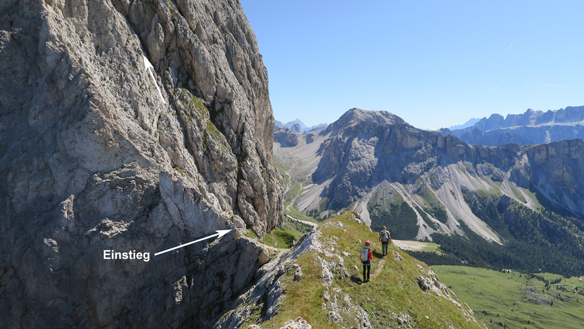