It very much depends on where in the world you are: There are paths in the mountains near me that were explicitly built for recreation.
1 Like
Both statements can be true and the same path may serve multiple purposes. Some paths may be easy to classify into those that are mainly for fun or recreation and those that are mainly for providing access to places. A great many others are used for both, and the primary use is not so clear.
2 Likes
There certainly are old mountain paths, e.g. this one is said to have existed for 6000 years - Weltkulturerbe Transhumanz: Bergtour vom Ötztal ins Schnalstal I Tirol - YouTube - but it does not qualify as a scramble. The scrambles in the surroundings certainly are not made for the stated uses. There is no reason to fear, that introduction of proposed tag will hide lots of pastoral or commercial highways from interested consumers of openstreetmap data.
Looking forward to getting briefed about situation in the Rockies, the Andes, the Himalayan.
Nearly two weeks passed since the RfC started. Quite some changes have happened. I’d like to invite a second reading, to help weed out remaining problems. Proposed features/highway=scramble - OpenStreetMap Wiki
Please comment in the medium of your choice.
Can you explain more why climbing=route is not chosen? If =route is an issue, you could use climbing=scramble? Unifying under climbing:*= would be cleaner than being highway= while none of its usual attributes apply.
Reason number one, I consider scrambling and climbing different activities. I am not a climber, I like to hike, scrambling sections are part of the game, at least on the hikes of mine. Yosemite Decimal System - Wikipedia mentions scrambling literally in-between hiking and climbing. From comments in previous discussions, native English speakers (both UK and US) seem to have little problems with differentiating.
Reason number two, Climbing - OpenStreetMap Wiki is quite clean and looks like the work of a small openstreetmap community that enjoys this pastime. There is no mention of “scramble” there, so (ab-)using their “route”, something that has a very well defined meaning, for scrambles seems to me the wrong thing to do. Inventing a new kind of “climbing” brings us to:
Reason number three, using climbing=* without a top level tag will trigger validators and QA tools. I consider the warnings justified. I rather leave that up to the climbers to make e.g. Way: Bear's Reach (706285415) | OpenStreetMap validate. Here to the video of somebody that makes this look like a scramble Dan Osman - Awesome - YouTube - I do not see such a performance a measure for openstreetmap tagging though. This definitely is not a highway=scramble.
1 Like
- By using
highway=, conceptually it is oriented closer to hiking. This andhighway=via_ferrataare unlike otherhighway=. This has the further difference of having no physical structure. It is “worse” than other usualhighway=path+informal=yes. and thetrail_visibilityhas a different meaning. - What is “without a top level tag”? You are proposing a new one anyway.
What I mean is you are already usingclimbing:grade:*=. Why notclimbing=scramblethen? Otherclimbing:*=attributes could be applicable too, not a climber so only guessing maybeclimbing:quality=andclimbing:rock=? Then you would be mixing them inhighway=.
Yes, indeed, scrambling is much closer to hiking than it is to climbing. And yes, indeed, hiking paths sometimes have no physical structure. It is just people going all the same way, that makes them stand out of the surroundings. Even on those that are managed, management often reduces to cutting branches from trees, that would grow into the air-space or digging small gullies to redirect water. The surface mostly is just bare ground. People love that. I strongly disagree with your judgement on via ferratas: They come with a very pronounced physical structure. The steel cable to plug the carabiners.
As far as I am confident with openstreetmap markup: What makes a tag top-level is the key. The highway key makes the tag a top-level one. The climbing key does not. The validators will still complain, when presented “highway=scramble”, because the value is unbeknown. It will just be a matter of community appeal to change that. I do not see any use in creating yet another attribute of “highway=path”, there are so many already.
2 Likes
It’s highway=scramble having no physical presence compared to =path (+ informal=yes) and =via_ferrata. So it is again more suitable to climbing= to me. (and even climbing=route will have climbing:bolt*=)
climbing= is top-level. That’s the validator’s problem. Shouldn’t tag for them. I can equally suggest we not bloat highway= any more. =scramble= is not about walking, or walkable infrastructure. Adding this there is less relevant and similar.
During the discussion I learned, that for not a few, a scramble on a hiking path is similar to steps on a footway. The proposal, to use “climbing” as a base for such scrambling sections is a sure fire way to make the combination of “climbing=*” and “highway=path” a lot more popular than it is now.
1 Like
Been hiking today, openstreetmap chose the destination  From talk on the railway station, I recently learned, that a path was graded too easy, T3 hiking, so I had to research the location. Here a picture:
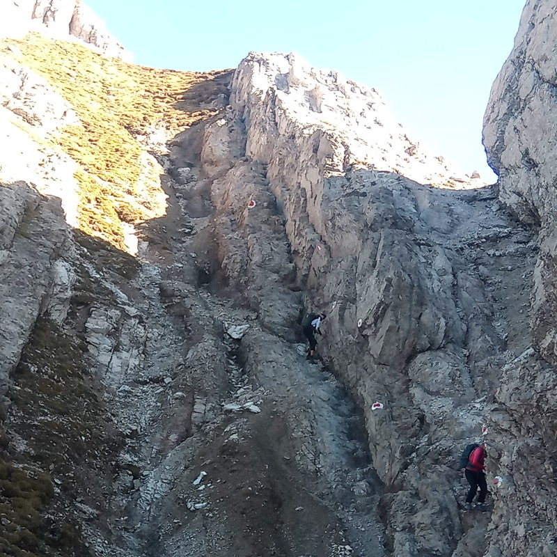
There is a steel cable running along the wall. I did not use it going up, I prefer hands on rock over steel, but used it a bit going down. @ezekielf I would like to have your opinion: Does such a section merit highway=scramble.
If you say no, I will immediately change the wiki to show this, as an example of what a highway=path is. Not that I think, this would stay for long…
PS: Where the scramble starts, there was a nice depot of walking sticks.
Looks fun! Were the cable not there, it looks like you’d ascend this crouched down scrambling with hands and feet. Since there is a cable you have the option to hold it while standing upright and ascend this way instead. Due to standing upright, I probably wouldn’t call this scrambling. However, I wouldn’t call it walking either. I’d probably call it climbing in everyday speech, though in a bit of a different sense than technical rock climbing that requires special gear.
So, regardless of what I would call this in everyday speech, should it be tagged highway=scramble? I think so, although this is an example of why I wasn’t sure scramble was quite the right word to use for this new tag. However, I don’t have a better suggestion to use instead. If the goal is to separate ways where it is possible to walk using feet only from ways where hands are also required, a way like this one clearly falls in the latter category.
Indeed, it is fun We are not alone in calling this scramble, AllTrails thinks so too - Kuhljochspitze von Hochzirl | Map, Guide - Tyrol, Austria | AllTrails - BTW, AllTrails calls this “hard” but they call the hike to nearby Solstein hut “hard” too, so I do not know, if I can trust them.
I think I would put highway=via_ferratta on this, but if highway=scramble was adopted, maybe that would be closer. If you have to use hands, than it can’t be just a path IMHO. In any case, safety_rope=yes should be there.
1 Like
I have difficulties to understand your comment ![]()
- What do you mean by “no physical structure”? The majority of scrambles I have been doing are showing physical structures that make them as distinguishable from the surrounding as a usual highway=path in the mountains, like waymarks, holes in the vegetation for air-space required by a person and because the feet reduce/remove grass and low bushes, different texture of gravel or rock or soil, some have rungs others holds/steps hammered into the stone and others ropes, etc.
- What do you mean by “trail_visibility has a different meaning”? I’d map and expect exactly the same meaning for a scramble as for highway=path.
That’s one of several reason why I find highway=scramble inferior to the alternative highway=demanding_path + demanding_path=scramble (or other wording): The latter seems to allow an automated edit for a considerable share of ways, namely all SAC T4-T6, see this tagging mailing list post – we must of course discuss whether we want to do or not.
As such a user, I do explicitly not want my mapping efforts to be visible on all maps because that’s against the very basic idea of having multiple maps: specialization. For example, I wish wheelmap.org or OsmAnd in car driving profile will not show scrambles, while waymarkedtrails.org shall. This way, maps allow me to better focus and perceive more quickly what is relevant in a certain context ![]()
3 Likes
I 100% agree.
I’m open to considering the idea of highway=demanding_path, but that would be a different, broader description than what @Hungerburg developed for highway=scramble. In your vote comment you say it is more verifiable and less subjective, but I do not see this. If I lived in a region where all hiking routes are given an official SAC scale rating by some authority then perhaps I would agree. Then I could simply verify if the rating was T4-T6 and tag highway=demanding_path. However this is not the case in my area of the world. There are no official ratings to verify against. So it would be a subjective assement on my part whether a given trail qualifies as “demanding” or not. On the other hand, I find highway=scramble intuitively verifiable even though it also is not free of subjectivity.
9 Likes
I do not want to speculate on the reasons, but the foot profile for OSMRF as applied on the OSM website certainly is one such app.
PS: Luckily, only few get into danger. In most cases, users just will turn around before they get into danger.
1 Like
Coming here late, but perhaps some thoughts that can be used moving forward.
Scramble can be used to describe anything from Class 2-4 in YDS so that’s a wide net. Having a highway=scramble lets me know that it’s not Class 1 or SAC 1-2, but I’m more concerned about whether there is fatal exposure and/or semi-technical sections than I am whether I have to use my hands every once in a while for balance. There is too large difference in technique from the low to high end IMO
A strict interpretation scramble as just “use of hands” opens up a lot of normal trails that overlap into YDS Class 2 terrain - the trail in Granite Park outside Pine Creek in the eastern Sierra has a few Class 2 sections and a mantle or two, most of the trails in The Needles in Canyonlands have mantles or drops in them that would push them into this label. I wouldn’t consider them scrambles in the fun semi-technical sense.
demanding_path is a bit odd to me (as many people consider a long or steep hike on a very nice trail demanding)
I could see this being broken down into a few stages that mimick major changes in ratings, though at this point the only real value would be not having this be a subvalue that people may ignore, but something that has to be entered. I’m not familiar with other regional systems, but they should be tested to see how they map onto this (countries that only have 3 are an interesting case, etc).
highway=path Class 1 YDS, SAC 1-2
highway=demanding-path Class 2 YDS, SAC 3
highway=scramble Class 3 YDS, SAC 4-5
highway=mountaineering Class 4 YDS, SAC 6
Breaking down trails in Needles that have some mantles, steps carved into sandstone, via ferrata, etc from those that are just simple single track into categories seems useful for your everyday tourist even if they aren’t “scrambling”.
As an aside:
How you move over terrain in reality is independent of exposure - one can walk on fatally exposed Class 1/2 (a foot wide but mostly flat ridge), or do a short Class 4 SAC 5/6 section which is short and unexposed but requires more technical or athletic skill than the average hiker has. In YDS I will personally shorthand things like “2 X” and “4 PG”, breaking apart technique and exposure into their own axii, but creating new technique and exposure keys is probably too much for this use case.
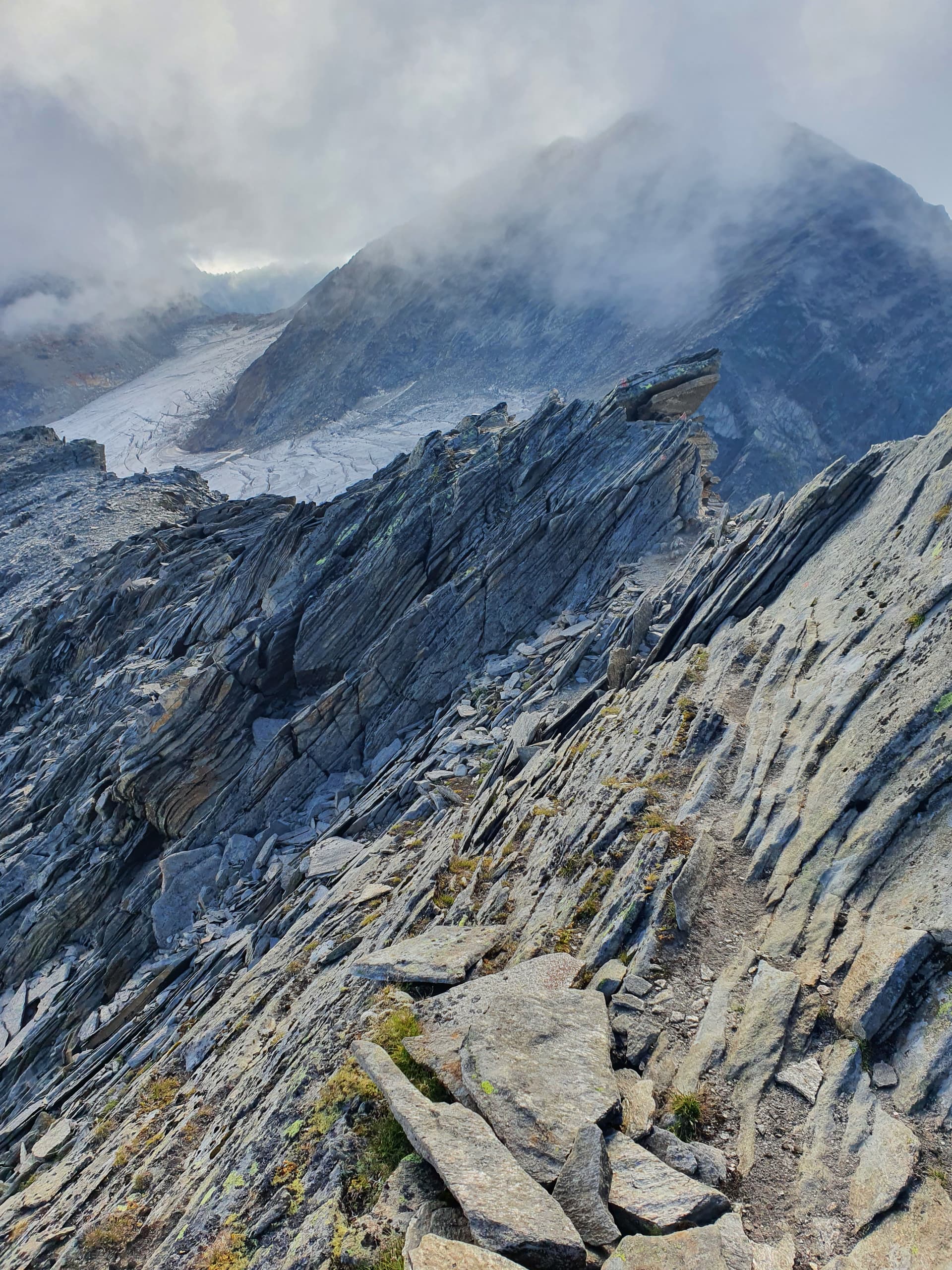
The following photo shows terrain where we didn’t have to use our hands, but is exposed. It’s still steep enough (and with enough variation that we had to “read” when to stay high or go low etc) that I wouldn’t put it as Class 1, but even at Class 2 it’ll unnerve some people that are comfortable in general on that terrain type. Is it SAC 2 due to the terrain, or SAC 4 due to being exposed?
3 Likes
This is a bit off topic, we could create a new thread for this… but to answer your question: it’s the hardest part of a hike that determines the overall level of difficulty, so SAC 4 (alpine hiking)?
I think you have to ignore the names a bit, your example isn’t “alpine” hiking either but it does have a similar level of exposure as many alpine hiking paths: