I’d say, that might be tagging mistakes and the latter paths rather mountain_hiking grade instead. SAC-Wanderskala – Wikipedia has pictures. Here one from location of one of the type-specimens in the Original SAC document, File:2008-07-20 Männlichen - 11.jpg - Wikimedia Commons
Still, I think that the gap between what we have in T1 and in T2 is too wide. The pictures have T1 as “pretty much a well maintained gravel road”. This is also T1, arguably even stuff like this is T1, both of which are far away from the T1 pictures in Wikipedia
I’d agree though that there might be quite some tagging mistakes, T2 seems to be underused in some cases.
1 Like
Your site only shows European countries, which isn’t quite “world wide”. It is used world wide on OSM, but that’s for a lack of better choice (I’ve used it in the US).
While I can abstract the general idea of T1 through T4 and find it useful for the majority of trails, it combines a lot of concerns. If there’s a path with uneven footing, but without a steady ascent, is it still T2? Amusingly the sole photo example on wikipedia violates its own main classification. If there’s some fatally exposed moderately steep (20-25deg) slab is that T1 or T2 for technique or T4+ for exposure? If you mark it as T1-T2 you’re going to have freaked out tourists, if you mark it as T4+ mountaineering types will be confused.
I’m not interested in editing sac_scale (though I feel like it could use some editing, it is what it is) in terms of “touching a running system”.
All of those keys are for motor vehicles:
Key:smoothness - OpenStreetMap Wiki very_bad, horrible, and very_horrible seem like they could be extrapolated to hiking paths if you ignore the vast majority of the text and just look at the pictures and the vehicle clearance required, If we’re going to normalize marking hiking paths with this key, then the majority of them would be tagged impassable which at least I find amusing.
Key:surface - OpenStreetMap Wiki is marginally useful for anything other than a highly developed trail. a compacted path of dirt vs a compacted trail of dirt with lots of rocks or roots in it would be the same value. hiking paths also commonly change terrain - you can be walking on compacted dirt, duff, sand, and granite slab within the same mile of trail in the mountains- I often find it useless when trying to tag a path. likewise in the desert a trail can be a mix of sand, solid stretches of sandstone rock, some gravel near a streambed, small boulders in a wash, etc. if we’re supposed to create a new path segment every time the surface changes that’d get very messy from a rendering perspective, not to mention that there just aren’t enough accurate values.
https://wiki.openstreetmap.org/wiki/Key:tracktype I can see being somewhat useful, but only really impacts how annoying it is to walk on (it’s really more of a hard vs soft scale) and doesn’t address the case above. again this key is meant solely for roads for motor vehicles.
I guess someone can look at those road keys and apply them to hiking paths with “vibes” but that seems like it’d just create more inconsistency over time.
Those two photos seem like they have more to do with trail_visibility (which is in very poor shape) than the actual difficulty of the trail, but sac_scale includes a lot of visibility related language in it’s values on the OSM wiki, though up at the top people are told to disregard them (lolwut).
Reading the values on the OSM wiki, it wouldn’t be unreasonable for someone to tag those two T1 for difficulty, or T3 due to “trail may have unmarked portions and cross fields of loose scree or talus.” and it needs “Good navigation skills” whereas T1 is “Orientation straightforward, even without a map.”
Technically T2 cannot be used on a trail without a steady ascent, is steep, and has fall hazards, regardless of what the actual requirement of “Some sure footedness” required. In the example below none of the other criteria meet it, and it’s “Orientation straightforward, even without a map” as well.
This situation seems like it’s hard to capture with values that are solely meant for vehicles:
Absolutely not. The page even uses “roller skaters” as an example. The descriptions in the “values” table use motor vehicle examples, but that’s part of the reason why I suggested on the other thread that obsessing about descriptions can be unhelpful.
1 Like
The opening sentence of the page: “smoothness provides a classification scheme regarding the physical usability of a way for wheeled vehicles”
The full text there:
The aim of this tag should be that navigation software developers can use its information to propose an optimal route depending on the vehicle the user is using. Many are already offering routing for cars, bicycles, pedestrians, and public transport: wouldn’t it be nice if they could add routing for roller skaters, SUVs, 4WD, etc.? Therefore, as a mapper, when you use this tag, you should ask yourself: “Will most people be happy if their routing software suggests taking this way with their rollers/racing bike/sports car/normal passenger car/SUV/4WD/tractor, or would they prefer to take an alternative way (assume there is one) with a smoother surface that is 30% longer?
Fair, it’s for “wheeled vehicles” and not “motor vehicles” - the first two examples are pavement, the third gravel, which are only found on highly developed hiking paths and which is where the majority of non-wheeled vehicles are.
From a pedestrian standpoint, am I supposed to just go with “vibes” for paths then if I’m going to not “obsess” about descriptions? Going off example pictures and ground clearance as I mentioned above would the only thing that makes sense to me. So a path that is smoother than 14cm, 18cm, 21cm, 24cm etc. People are going to measuring 3cm differences in the real world. So then we’re left with a single picture for each value and how the value name makes us feel.
Shotgunning keys with a lot of subjective values is an interesting approach. Instead of trying to create consistent meaningful systems with clear values, just create vague ones that have a lot of values (8 in the case of smoothness in how it would impact hiking paths and pedestrian traffic) and people can pick what “feels right” and those get collapsed into buckets by clients later for rendering. I’ve heard this in defense of the current trail_visibility - it doesn’t matter if bad, horrible, and no are ambiguous and poorly defined because they’ll be stippled the same and it keeps people accidentally moving from horrible to intermediate by having something in between.
Maybe we should just have people rate keys on a 1-10 scale and call it a day, then clients can decide if their good is 7-8 or 7-9 or whatever.
I’d like to understand better why the scale is supposed to be Eurocentric. The name of the key and values certainly are, but we can ignore that for a moment and pretend it’s just hiking_difficulty=T1, T2, etc. Then to me, sac_scale as it is used in OSM is mainly about two things: technical ability (sure-footedness etc.) and exposure (“head for heights” etc.) The wiki page calls these “terrain” and “trail”. The other stuff (under “requirements”) is really just a guide and not directly useful for classifying a path. For example the stuff about footwear or how much experience you need.
Focusing on technical ability and exposure makes the scale quite applicable internationally, doesn’t it?
For example, I see no reason we shouldn’t tag a cliff path as T2 (“mountain_hiking”) even if there isn’t a mountain in sight.
When exposure is bad but the walking is easy, or the other way around, then in my view we need to classify it as the higher of the two: someone who is only comfortable up to T2 certainly won’t want to walk this path.
By the way, I’ve never hiked in Switzerland. The German Alpine Club has a comparison of German, Austrian and Swiss scales that I found helpful when learning about sac_scale. Maybe we should do the same with more scales from outside Europe and put it on the Wiki, to help people “translate” values from a scale they know, along with a gallery showing example images from other parts of the world?
I try to tag paths I hike with smoothness, imagining what it would be like to ride my bike on them. wheelchair=yes is another tag I have found useful. (If it’s fine for a wheelchair it’s also fine for a pram)
The fact that the smoothness page says the key is for vehicles (which includes bicycles) and then uses roller blades (which aren’t vehicles) as an example is one of the countless ways the Wiki contradicts itself. I would suggest changing the phrasing to “movement on wheels” or something like that, but I’m worried that would also lead to a long discussion thread.
3 Likes
Definitly. What I want to say is that I feel that having them in the same category as this doesn’t feel right to me. Wide gravel ways shouldn’t be in the same value as semi-overgrown ground single-trails, unless our focus is heavily on the atleast semi-experienced alpine community.
If we want any hiking-tag to be valuable to the casual user, sac_scale T1 is too broad.
1 Like
That’s what I’ve been doing, and while it is intended for alpine environments I find it useful in other ones (sandstone rock in the US southwest etc). I personally think the bones of it can be adapted into a good system (or systems) but at the point where large parts of the text need to be ignored that IMO is an issue.
So that would be ignoring the trail and requirements section, and solely focusing on terrain.
In general it’s not clear which majority of the aspects are ignored, and which single one is being prioritized. In an area where sac_scale is actually used perhaps these would be clearer to guess, but honestly I would have no real idea what to expect from T2 terrain. It could be any combination of the following:
- a trail with a steady ascent
- trail that is uneven enough to require sure-footedness and good footwear
- a trail that has some “fall hazards”
- a trail that requires some navigation skills (but ignore that part)
IMO an unexposed trail with a smooth path shouldn’t be T2 just because it has a steady ascent. That’s kind of goofy IMO, and we can generally get elevation gain metrics etc from mapping clients these days anyways.
As someone who has never hiked on a sac rated trail, I’m not sure how they interpret the differences in exposure between T2 " may pose fall hazards", T3 “Portions of the route exposed with danger of falling”, T4 “Terrain already quite exposed”, T5 “Exposed”, and T6 “Severe exposure”.
T6 I would take to be knife-edge exposure, sheer drops with a path a foot wide at most. T5 and T4 I’m not sure of “quite exposed” I guess is more indirect, some ledges below you or something, or a steep slope you could possibly self-arrest on. T5 would be, in between the two? T3 feels more like “this trail may spook you but you’d have to kind of try to fall off of it”, T2 is you might trip and fall or lose your balance on a piece of talus. Can some European users comment on this take?
I would argue that “fall hazards” probably means that you could “take a fall” walking on an uneven surface (judging by the sample photo on the wiki and escalation that mentions falling and exposure later) and not exposure, and that trail would be T3 “Portions of the route exposed with danger of falling” despite looking like a nice smooth single track trail.
I feel CAI T & E do a better job than SAC T1 & T2 for less demanding trails.
That’s not going to be how non scramblers / mountaineers will think about ratings though. At the very least the wiki page should make this clear - that a T4 route can refer to either T4 levels of exposure or T4 levels of difficulty.
Having a smooth single track trail be marked T3 because it is near a cliff-edge is going to confuse people, there’s going to be an expectation of rougher terrain.
Comfort with those two don’t always go hand in hand. My partner enjoys unexposed T5 technique level terrain when hiking, but doesn’t enjoy fatally exposed T2 terrain. In my own shorthand adaptation of YDS and the risk movie rating criteria for class 5, I’m generally comfortable with 4 PG, 3 R, and 2 X when out hiking.
Imagining riding a bike on them seems like a reasonable way of approaching it, and I agree that using wheelchair=yes on highly developed trails that are accessible is a good thing to do! Smoothness only covers T1-2 terrain though using YDS it’s all variations of Class 1. I suppose anything beyond that level of smoothness would be assumed to be SAC T3, but this is getting into “read between the lines and ignore 95% of the description and values and then adapt it to a subsection of another key and figure that out yourself” which isn’t really a reasonable ask of the average person wanting to help rate a path.
Rollerblades are at least a wheeled mode of transportation made to be used on roads made for vehicles, I feel fine giving that one a pass. ![]()
+1
A more reasonable trail_visibility where excellent wasn’t the only value that had a contiguous path (lolwut) would allow for this, and this is a point that @Hungerburg has been rightly insistent on making.
If there was an excellent that roughly mirrored the NFS Class 4-5 specifications for visibility, then good was along the lines of NFS Class 3, with 2/1 inspiring a poor and bad or something I think it’d be more useful and approachable rather than the current system in which 2/3 of the values are for some level of pathless terrain. I feel trail_visibility is more broken than sac_scale.
At this point it’s a busted system with a lot of use which makes it hard to change in any meaningful manner, and IMO there is a regional subjectivity to path visibility, creation, and construction that doesn’t exist with just movement over terrain (I agree with @osmuser63783 in this, just not that sac_scale does it well enough for a general casual hiking population). Having some new subsets of trail_visibility that use the old one as a fallback would make sense. Australia probably has different standards for trail visibility given people are used to walking through the bush than the US or Europe etc - if the Swiss are fine with sac_scale based visibility, that’s great they can keep using it as the first if before the else.
The problem with the full planet is that my small test site has not enough CPU power and RAM memory.
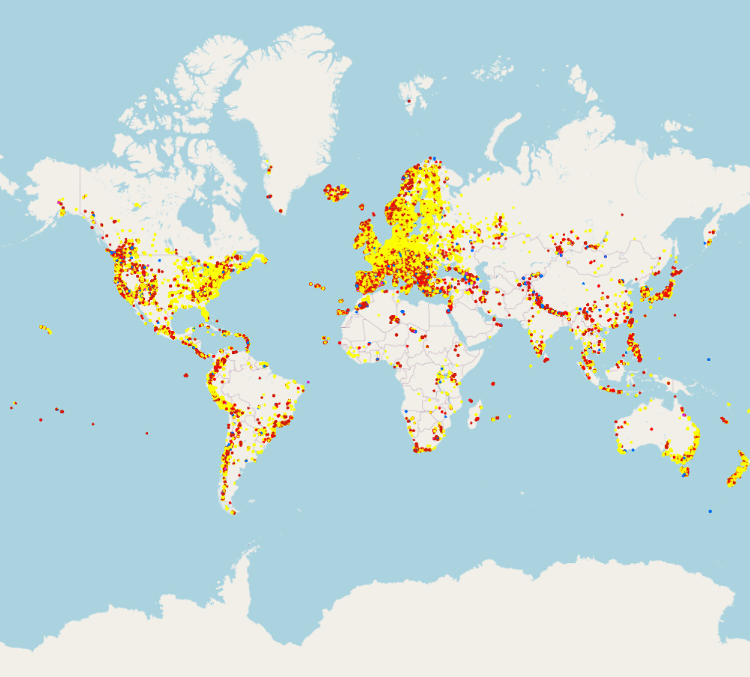
You can see on the attached screenshot that sac_scale is used word wide:
Peter
I just asked my partner (who like me spends a lot of time in the wilderness, alpine or otherwise, but comes from a different background of leading wilderness trips in the NE US and Montana). She wasn’t happy with the options, but chose T3 unprompted. If we’re confused or doing it wrong, I imagine a lot of people outside Europe will be confused and doing it wrong!
That cliff trail isn’t a great example of what a T3 trail is supposed to be, and having it tagged as T3 is going to mess with more “true” T3 trails.
Edited out two line about lunch from an existing conversation before I asked this. ![]()

I edited this into the post above so it might get lost for people that read email updates, but is relevant here:
As someone who has never hiked on a sac rated trail, I’m not sure how they interpret the differences in exposure between T2 " may pose fall hazards", T3 “Portions of the route exposed with danger of falling”, T4 “Terrain already quite exposed”, T5 “Exposed”, and T6 “Severe exposure”.
T6 I would take to be knife-edge exposure, sheer drops with a path a foot wide at most. T5 and T4 I’m not sure of “quite exposed”. I guess it is more indirect, some ledges below you or a steep slope you could possibly self-arrest on. T5 would be, in between the two? T3 feels more like “this trail may spook you but you’d have to kind of try to fall off of it”, T2 is you might trip and fall or lose your balance on a piece of talus. Can some European users comment on this take?
It used worldwide on OSM because it’s the only option for trail difficulty.
It is not used in the United States on the ground as far as I know. If it is I’ve not encountered it in multiple states, national parks, state parks, informal trails, frontcountry hikes, backcountry hikes, peak bagging, off-trail passes, mountaineering beta, etc over years of trail time. I’ve never had it come up in discussions with mountaineers / scramblers when talking about routes, on major off-trail discussion boards, etc.
My first exposure to sac_scale was from OSM, and that’s the only time I use it. I imagine there’s a significant amount of people worldwide for whom that is the case.
Here’s a proposed key for the terrain aspect of things. I don’t think it’s perfect, and expect it to be changed from constructive feedback, but I feel it’s more understandable and verifiable than what exists.
That’s probably true (although as I suggested above, other tags such as surface etc. would also help people understand how difficult trails might be). Usage of sac_scale in North America can be found at https://taginfo.geofabrik.de/north-america/keys/sac_scale#values, and within the USA at https://taginfo.geofabrik.de/north-america/us/keys/sac_scale#values.
Surface really needs to be multi value with expanded values to be meaningful in terms of difficulty unless people are creating new ways every time the surface of a trail changes. Outside of paved and maybe gravel it doesn’t say much about difficulty IMO. Even naturally occurring gravel can be loose and somewhat treacherous, or at least tedious. Multiple people have said to use compacted for nice single track trails to differentiate from just dirt which is looser, but that would indicate it being in between pavement and gravel.
Would a smoothness=very_horrible surface=rock be many 8.5" rocks or one large slab that is uneven up to 9 inches? There’s 7 values for smoothness up to 9 inches (which honestly isn’t that high in terms of the unevenness that can exist on hiking paths), and one value after which is impassable. Would impassable be rocks in a streambed you can hop around on, talus you need to use your hands for balance on, or a rock face that you need to scramble up? In theory you can make guesses based on sac_scale, but sac_scale isn’t used consistently in terms of the surface and can be referencing path existence, angle, or exposure instead - case in point the nice dirt single track that would be T3 up above.
That’s a lot of granularity and interconnected keys that were meant for non-wilderness use to an ambiguous end result. Heck surface has grass_paver as an unpaved surface. ![]()
I’m sorry - I’m trying to be helpful here.
Yes, people who map stuff face the challenge of “how often should I change the surface tag”, but an approximation of surface information is better than none at all.
Perhaps the next time you’re out in the wilds keep a note of the tagging challenges you faced and write it up as an OSM diary entry?
1 Like
Let’s compare apples and oranges! Both shaped ball-like. They are the same!
There is also this picture, I repost here for your convenience:
.jpg)
Original source File:SAC SCALE T1.jpg - OpenStreetMap Wiki
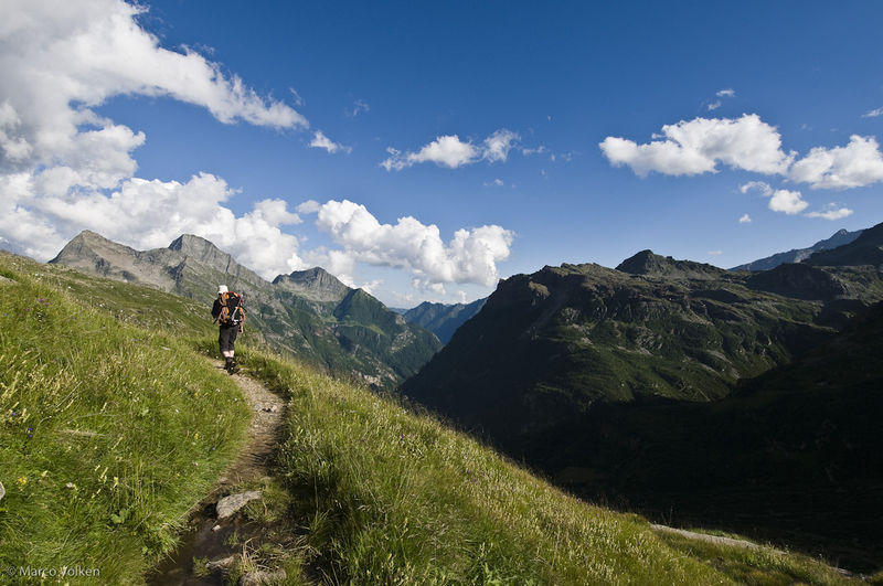
It shows a mountaineer hiking an approach path. The photographer certainly is knowledgeable about the SAC scale (mind the CAPS). I’d see a USDA NFS class three trail. This might be the low anchor of hiking.
In the first mapillary picture, I do not see a path at all, the path in the second picture looks “steeper” than the T1 one above and less developed. Though I guess I’d have no problem going up or down there on my trekking _not: mountain bike, nevertheless, mountain_hiking might be justified by some, but up for debate by others.
Continental European interpretation was called for, so I answer: The Konjunktion (conjunction, obsolete according to wiktionary) is “or” rather than “and” or “regardless” ![]()
PS: “sure footedness” I know from places, where falls might be fatal or cause severe injury, but it also might be signed on places, where tripping can bruise your nose only, which is about anywhere, but to indicate a higher likelihood perhaps, due to rough surface?
PPS: These “Trittsicherheit erforderlich” (“sure-footedness afforded”) signs were found to not hold judicial deliberation, because they miss out the specificity required for warnings posted alongside of ways.