I am happy to first discuss whether such a feature would be possible and secondly how to implement it. There were some more sophisticated approaches in the previous discussion and I do not know the canonical solution.
hitchhiking=no should probably also be documented, as it is not true that “technically one can hitchhike in any place”, at least legally. The US even has a road sign for it:
As an complement to both comments, wouldn’t it be clearer to have “hitchhiking” as a key applicable to other tags? For instance: petrol station (fuel) ; hitchhiking bench (more on this one lower); highway entrance…
The main value would be “hitchhiking=yes” to mark any spot where people do hitch-hike.
Then, you could have the following accessory values (which could be another key like “hitchhiking:status” if cleaner):
hitchhiking=illegal → to mark where it is illegal to hitch-hike (unnecessary if there is access:private)
hitchhiking=official → to mark official hitch-hiking spots (built or encouraged by the legal authorities) ; can’t be used with “illegal” and “informal”, nor “access=private” ; this one would render on the map as a thumb.
hitchhiking=informal → to mark often used hitch-hiking spots by the local hitch-hiking community (may be not precise enough).
Regarding “bench:hitchhiking”, adding the hitchhiking key would make it easy to solve! You’d have “amenity:bench” and “hitchhiking:official”.
OSM like precise definitions and whether a spot is good or not is hard to tell, and I guess this is where a voting overlay of some sort is necessary as I can’t see how it would fit OSM data.
This structure makes more sense IMO. It’s hard to see how it could be different. Hitch-hiking is technically a mean of transport, but a spot isn’t an amenity nor even a structure. The same way, it isn’t any road where hitch-hikers can access (thus making it “access:hitchhiker” unworthy). Someone knowledgeable than me can develop or contradict.
Aparte: You could also add something like “hitchhiking-car-speed=fast/slow/stopped” where it denotes the speed of cars—which can be vastly different between highway shoulder, gas station and country road (yet is mostly immuable, compared to “hitchability”.
I don’t think that this needs a “wiki proposal”. The existing wiki page has been largely ignored since 2008. There is low-level usage as a key and as a value, and that’s absolutely fine.
Anything more formal, especially where there isn’t a bench or a sign, will just run into verifiability issues.
A few questions as it seems like you can give knowledgeable advice…
A few questions as it seems like you can give knowledgeable advice…
(didnt check the present usage of hitchhiking tag - thanks)
The idea of the proposal was to unify the interface by which one can query hitchhiking spots e.g for https://hitchmap.com/. Besides that we had the problem of of spots on hitchmap that were attached to a gas station that was abandoned. The spot disappears with the gas station so it would make sense for us to match our spots to OSM features.
towards a unified interface. could one just go and change the tagging of the existing keys and values to whatever we decide on in this discussion? hitchhiking=local is used quite a lot but not documented anywhere which makes it unusable for people except the tagger themselves.
I wasnt aware that one does not need to go through the proposal process. As there are about 50k spots on hitchmap that I had in mind to put on OSM I thought it makes sense to agree on an interface. Could I just add new tags in this order of magnitude without asking anyone?
Thanks for the pointer. I read about Verifiability. What we had in mind was that as soon as someone hitchhiked in a spot it is recognized as such. I see that this is not really verifiable as it is a temporal property e.g. Hitchmap - Find hitchhiking spots on a map - Add new spots. Still there are informal spots that are frequently used for hitchhiking e.g. Hitchmap - Find hitchhiking spots on a map - Add new spots that is frequently verified by new comments. What do you think about such spots?
OSM supports free tagging. It absolutely makes sense to discuss higher usage keys and values, but for others just trying to fit in with broader principles (like verifiability) is fine. It’s perfectly possible to merge tagging later, provided that it’s clear what the original mapper meant.
That sounds very much like an import, and you’d absolutely need to discuss that before doing it. I had a look, and all of what is on hitchmap local to me wouldn’t be appropriate to OSM.
If they’re verifiable, like the German hitchhiking benches, then yes - but otherwise no. Verifiable doesn’t mean “someone said they hitched from here”, it means more like “a random OSM mapper would recognise that people hitch from here when walking past”.
The process for this can be found here. You’d also need to make sure that people who had mapped e.g. hitchhiking=local were aware of the discussion here. It’s fairly widely used so clearly more than one person understands what it means. See also here in the forum previously.
I would imagine that hitchmap.com would want to show:
The “verifiable” data from OSM
Other “unverifiable” data from its own database (presumably as now)
“value judgements” (good or bad place etc.) also from its own database.
Can we use this discussion to align on a preferred tagging for official hitchhiking spots?
hitchhiking=local
highway=hitchhiking
highway=hitchhiking_bench
are each used about 100 times on the map. So these are the de-facto standards.
when comparing to Tag:highway=bus_stop - OpenStreetMap Wiki highway=hitchhiking makes the most sense to me - this would be for any official hh spot even for traveling.
whether it is a bench or not can be indicated by “bench=yes” (just like for bus stops) so we can map the concept of a “hitchhiking bench” that indeed exists.
I am not entirely sure about local - does someone have a good example where a similar tag is used?
neither here Mitfahrerbank wie mappen - #26 by Map_HeRo nor here Tagging: Mitfahrerbank? - #13 by Peer_van_Daalen there was an consensus for “local”,
If you are going to add this, IMO (and maybe this is a US thing) but you need a value for the places where hitchhiking is not illegal, but where signage exists that specifically discourages drivers from picking up hitchhikers. This is common around prisons.
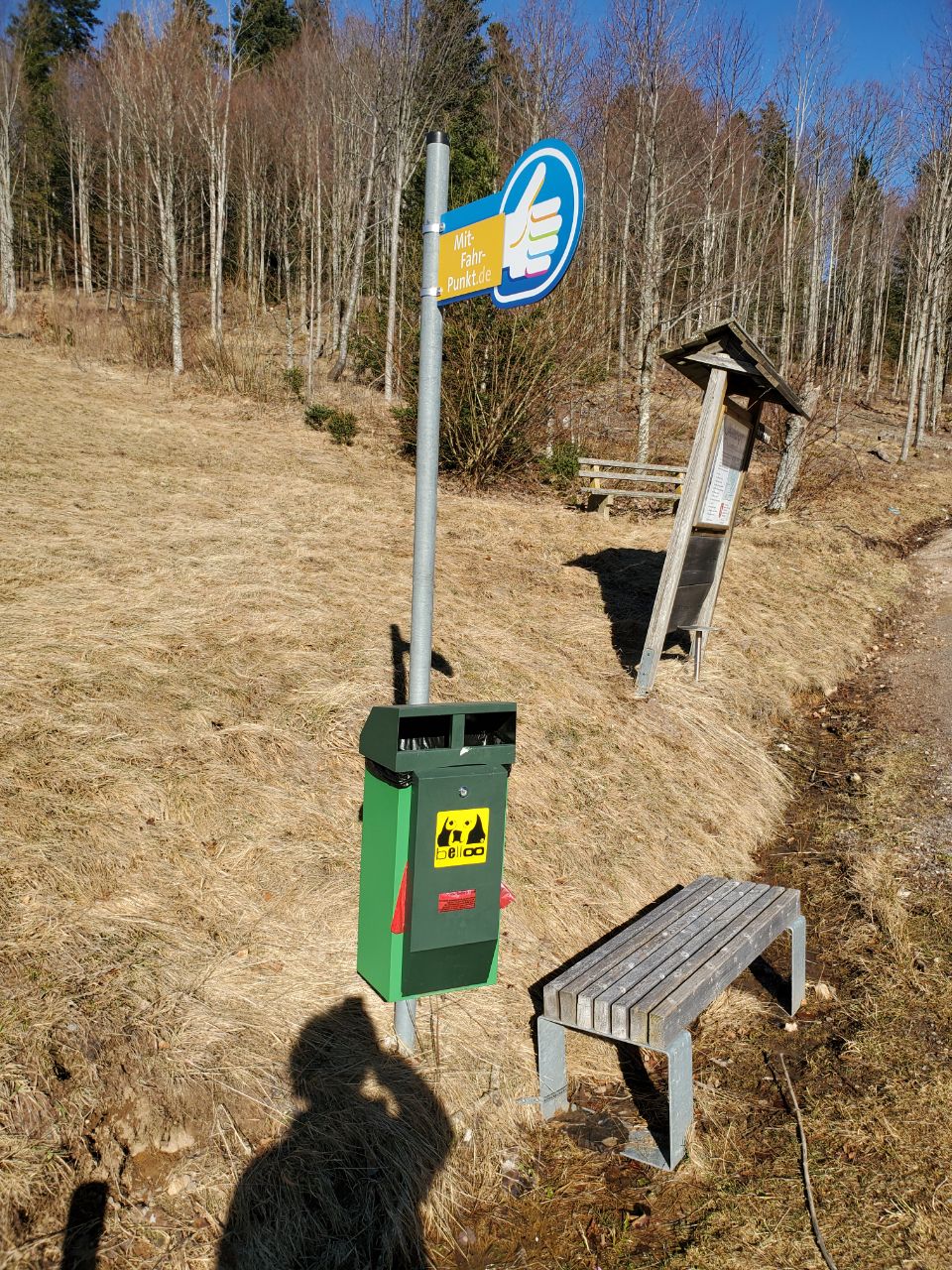
I’m not sure this and similar discussion have reached a conclusion, yet. Maybe a specific example helps: There is an organization mit-fahr-punkt.de that puts up signs for ride-share stops, like this one or this one. The first example has a bench, the second doesn’t. Since the respective administration has to permit putting those signs there, it seems somewhat official and beyond what hitchmap.com intends to show and allows for most aspects discussed.
The organization (and similar ones) might even provide the data in a suitable format if asked.
danieldegroot2 made a suggestion and pointed me to this discussion. After reading this discussion, Kreuzschnabel/Proposed features:Hitchhiking bench and Proposal talk:Hitchhiking - OpenStreetMap Wiki the following seems to fit best the intention of the stop:
highway=hitchhiking
hitchhiking = official
name=Mit-Fahr-Punkt
brand=Mit-Fahr-Punkt
brand:website=https://www.mit-fahr-punkt.de/
bench=yes/no
One could add the features otherwise used for bus stops as well:
shelter=yes/no
bin=yes
pole=yes
etc.
and in the first example
amenity=vending_machine
vending=excrement_bags
etc.
