We are prefectly aware of this and we have already spend quite some time into discussing and adjusting this proposal with people.
From the proposal about landuse=forest, natural=wood, landcover=trees: These tags continue to be used to tag physical, tree-covered areas, regardless of whether they are located within a delimited forest or not. This issue is not solve yet and landcover can still be a nice way to map areas covered in trees as part of a forest. We were not aware of boundary=forest so it might be something to look at
I’m not particularly interested in the discussion, but I’ll add an example that I feel is relevant.
Nearby there’s a church and all around it there is a restraining wall. Inside the wall there’s also some walking area and most of it is grass.
The whole area inside the walls is tagged as landuse=religious, I imagine the whole grounds are property of the church.
I do believe that adding landcover=grass to tag that area may be sensed. But I really cannot be bothered with that.
In both cases, boundary=forest functions more as a administrative boundary rather than indicating the border of an ecosystem like natural=wood would do in our proposal. Smaller sections of forest in the examples above can be tagged with natural=wood and consequently with the appropriate landcover tags.
Nha. In a lot of cases, the extend of the beach indeed is the same as the material (e.g. sand of gravel) and then you can use natural=beach + landcover=*. And if there are multiple landcovers, you draw the extend of the beach and fill it with landcovers
Yes and the administrative boundary is relevant because it has a name. It is important that maps include named features. What is to be gained by drawing the “border of the ecosystem” (not corresponding to any administrative boundary)? Is it a named area that people actually refer to, or is it a construct that only exists within your head?
You can also view it the other way around. By deprecating competing tags, we create a clear and understandable tagging scheme. See the discussion around the various tags for example for grass and forest.
Test: How to tag this in new ‘landcover’ scheme? Mixed tree covered area with open space inside, could be grass, could be farmland, could be orchard, could be grassland
Thanks for this, it is nice to explain by example.
The trees can be tagged with landcover=trees. It does not matter that it is mixed because you can assign leaf_type=mixed.
As for the area in the middle, the proposal does not help you to differentiate between farmland/ orchard and grass. Now lets assume that the area is grass. What the proposal helps you with is that despite its function, you can tag it as landcover=grass. Another mapper can tag it with for example landuse=meadow if he/she knows the function. For now, you tag what you can objectively observe, there is grass.
These patches of forest can together be part of a larger forest tagged with natural=wood
As for grassland, the proposal says the following about the natural key:
Natural: The natural tag should solely be used for natural entities like landscapes, landforms and other physical features. Think of volcano’s, plains, beaches, caves, wetlands, forest (continued to be tagged with natural=wood), tree_rows, valleys and water bodies like lake and rivers (continue to be tagged with natural=water).
Grassland also fits under this definition, the same as natural=wood, more to tag an landscape/ ecosystem consisting of smaller patches of landcover.
Argh, forgot the 64,000 USD question… given your shock comment along the line of (as what I perceived as said) “if made inner it no longer is part of the forest”, similar to those who fulminate about a pond made inner to a park suddenly no longer part of the park (rolls eyes), which of these are to be given an inner role on the outlines of
grass
grassland
orchard
farmland
march
wetland
In short, to multipolygon or not to multipolygon (assuming the wood/forest is a single encompassing outline/area?
Have the data consumers been polled as when the renditions the right honourable mappers are used to refer to go bonkers your proposal will find a grand abort.
Things inside an area’s an inner rings are not part of the area. Just as things outside an area’s outer rings are not part of the area.
Maybe I’m misunderstanding your comment, but it seems as if you’re framing this notion as ridiculous. It’s not, though. Inner rings are every bit as much a boundary of the multipolygon as outer rings are.
Given this reaction, I think my other response was maybe misinterpreted. Imagine if I have have a country border and I create an inner. Then I have an enclave inside that country. Under the assumption that the proposal is approved and natural=wood would serve as border for an ecosystem, then cutting a hole in that natural=wood would exclude that area from the ecosystem. You can (and should) of course cut out a landcover=grass from a landcover=trees because otherwise you have overlapping areas.
Got trouble picturing how to cut a landcover=grassland patch out of a landcover=trees patch. Is it
natural=wood + landcover=trees and then the grassland as an inner object of that wood. Sorry but just want to be sure nothing gets lost is translation.
As for the park example, we got a pine tree reserve here which is designated as a park at the same time. It has a large pond in it which has a small pine covered island islet in it. They were given outer/inner roles as else the trees would grow out of the water in the standard map rendition.
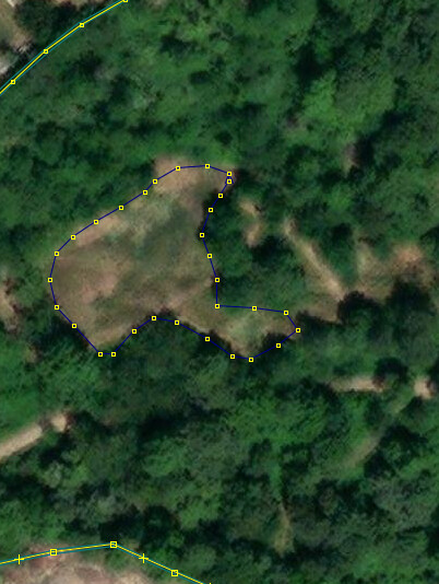
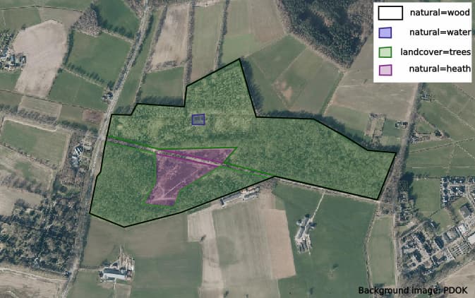
No problem. I made a quick tagging example below. The black area is the area tagged with natural=wood. That is the forest ecosystem. This area consist out of smaller areas:
Of course, lots of landcover=tree
At the top, a small body of water (blue). Here you need to create a multipolygon with the water object and the landcover=trees it is in.
There are some heath areas. Note heath continues to be tagged with natural=heath for now. The proposal does not seek to reform that now.
In the case of your park (leisure=park I suppose), it consists out of smaller areas of landcover, natural and landuse. leisure=park is used to indicate the total extent of the park area. You shouldn’t cut holes in that.
Apparently the “ecosystem” exists only in the heads of the authors of this proposal, for they have never given a concrete description of how this corresponds to ground truth.
A forest is a type of ecosystem. It is about mapping an area of predominantly trees. See also the quote from the wiki below. It is nearly impossible to come-up with a definition.
A forest is an area of land dominated by trees.[1] Hundreds of definitions of forest are used throughout the world, incorporating factors such as tree density, tree height, land use, legal standing, and ecological function
I know that a forest is an ecosystem. The matter here is that the boundaries of such an ecosystem do not exist outside your head and nothing would be gained by marking it in the database.
I am against this proposal, as it is nothing but a rehashing of existing tags to fit author‘s mental picture of the world that does not correspond to ground truth.
@Ferrocarriles_de_México we got it that you are against this proposal. This is ok and thank you for your participation in the discussion.
Also you say that the proposal is something only in the heads of the authors. You cannot say this, as you do not know who else thinks like this (for example the “ecosystem border” exists in my head as well). Please stay with what you think and stop guessing what others think.
What on earth does a general article in wikipedia of all places have to do with the specifics of OSM tagging? For the avoidance of doubt, tagging “named forestry areas” in OSM is a solved problem.
OpenStreetmap’s quality is not improved by using slightly different tags to map what we already have. It IS improved by going outside, surveying more things, and adding them accurately to OSM. Please stop sealioning and wasting everyone’s time - go outside and map.