We are a startup focusing on decarbonisation. We use building data for energy modelling and propose highly specific energy conservation measures. We’re exploring a concept to further improve the quality of building data available on OpenStreetMap.
Our idea revolves around a revenue-sharing model where contributors who enrich building data could earn a part of our revenue. The payment would be linked to each building added to a user’s portfolio in our app, where the building data has been enhanced by the contributor. For each building, there would be a main editor and a randomly chosen reviewer. Both would receive a share of the revenue.
To give you an idea, each of our customers manage between 100 and 10,000 buildings.
Please note that all the refined building data would remain accessible on OpenStreetMap.
At this stage, we’re looking to understand if there would be interest in this model from the community. Also, we’re keen to ensure this proposal would align with OpenStreetMap’s policies and community guidelines.
We’re in the early stages of brainstorming this idea and before getting ahead of ourselves we wanted to get a feeling of the potential interest.
66 views and no answer. I guess that is a clear sign that there is no interest
I think your post has remained too vague. Where are you operating (globally?), what kind of data are you interested in, is it already tagged in OpenStreetMap or do you propose new tags? How much revenue do you expect to create/share? Etc.
So, you are going to pay people to edit OSM, but they have to use your app as opposed to existing OSM editing tools? Nothing wrong with that per se, just trying to understand. Can the work be done using satellite imagery, or will an in person visit be required? Perhaps some examples of the type of “enrichment” would help us understand.
I don’t think it is a good idea. Firstly, you will only be able to offer a very meagre reward to these contributors; likely, much less than they could earn by engaging in other computer-based activities. Speaking personally, I enjoy conributing to OSM in my spare time but if I were to start viewing this as a “job” then it would lose the fun, and earn me less than other jobs.
Secondly, and perhaps more seriously, similar schemes in the past (OsmAnd used to run something like that) have tended to attract people trying to “game” the system by making edits that would earn them money but that were not ultimately useful to OSM. You would have to design your remuneration scheme very carefully to avoid these effects.
Thirdly, mappers would have to reveal their identity to you in order for money to change hands (at least if we’re talking actual money as opposed to coin bro toys).
I think that you might be better able to motivate people in immaterial ways. Take a page out of HOT’s playbook - have league tables, publicly thank prolific mappers, provide mechanisms (and maybe supporting materials) for people to “claim” a building and enrich it… stuff like that. Approaches like that would not suffer from the issues I mentioned.
Thank you all for your comments. Very helpful. I will summarise the responses in this post.
Just a reminder that this is an initial idea. We haven’t figured out all the details yet. Before doing that I wanted to understand the potential interest.
Our goal is make the global building stock more energy efficient. We can use our technology to predict how much energy a building is probably using, but to do that we need more accurate data. And we need to do this at scale. If someone helps us towards this goal there is nothing wrong in remunarating that person.
@dieterdreist
At the moment the plan is to start from the UK, then Europe, US and India. We are focused on portfolios of buildings. So the total number of buildings would be in the order of a tens of thousands to begin with.
This is what we need to build and simulate a basic energy model for a building:
Footprint
total height and number of storeys. Ideally a breakdown of levels
@tekim I don’t think everything can be done via satellite imagery.
The bare, bare minimun that we need is footprint, height, number of storeys, use and windows to walls ratio.
We will be charging per building per month. This is a wild guess at the moment as we are still testing our pricing strategy, but i would think that the reward would be in the order of a few GBPs per building per month for a period of a year minimum.
This would be shared between editor and reviewer with a ratio of 70%/30%
@woodpeck comment about ‘gaming’ the system is something I had thought about and the randomly selected reviewer was my crude attempt to address it, at least in part.
We are talking about actual money.
You could also think about splitting the in-person visit from the OSM editing.
Let users take photos of the building, maybe from all publicly accessible sides. You can outsource this to a micro job app, who also handle the payment aspect.
And then provide the photos and additional info to OSM editors who can edit the building data remotely. I think they would do it for free if you can motivate them and make the data available conveniently. You could e.g. use MapRoulette for tasking and reviewing.
That is a decent amount of money, substantially more than the tiny sums offered by previous schemes. I imagine this could indeed motivate people to add the kind of data you’re looking for. Of course, it also raises the stakes in terms of “gaming the system” as well, and it is going to cause some inevitable tensions as people who are not currently part of the OSM community get motivated to contribute for the financial reward. That would make it essential to have good relations with the local communities where you’re rolling this out and pay attention to best practices for organised editing such as the Organised Editing Guidelines.
I like that the attributes you’re considering are mostly covered by existing tags and that all of them have use cases other than just your own (e.g. they would be quite useful for 3D rendering as well). This means that having them in a shared database such as OSM offers a genuine benefit over a private data collection.
Not quickly, reliably or consistently. Having these sources conveniently available could get you from having level information for 5% of buildings, to, say, 25% in a couple of years. But it won’t get you anywhere close to completeness. Doubly so for the more niche tags.
After all, it’s not as if most buildings with a roof shape that can be distinguished from aerial imagery already have the corresponding tag. It’s not just, and perhaps not even primarily, due to a lack of sources, but indeed due to a lack of time and interest by volunteer mappers.
You are right about ‘gaming the system’. However, thinking about our current workflow, I am not sure that it will be an issue. I do not expect people just starting updating building.
Our users will first create a portfolio. This might cover an area or simply be a collection of buidlings across the UK (for the first version). The addresses will be put somewhere like MapRoulette (thanks @hfs for the idea!!) and only then they will be editable.
3D rendering is something we are also considering. Although not required for an accurate simulation, it is always good when something looks nice . We are using Cesium at the moment so not sure how this will work.
Yes, we are still thinking how to handle large areas. In that case we do not really need every building mapped, but that is an issue for another day.
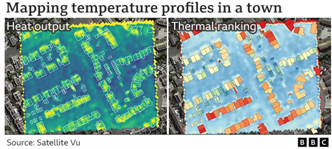
Thank you @ImreSamu Very useful information. We heard about Satellite Vu. It will be great for houses although I would argue that the problem is not to know that you do not have insulation, but having the money to install it.
For non-domestic buildings the problem is more complex. This would be a useful data point for sure, but not enough to provide recommendations for energy conservation.
The research paper is also very interesing and I am reading it. I had seen a similar one. The problem is certainly there. Given the massive number of buildings in need of decarbonisation, the only way is via automation.
In Italy there’s a building renovation bonus of what is advertised as 110% ecobonus. You get to deduct the cost of the renovation from your income/wage taxes spread out over a 10 years period. How the Italian 110% Ecobonus works for home renovations - N26
Those labels are used across Europe. Unfortunately the calculation methodology is so simplified that they are not really reliable. This means that you really cannot trust recommendations on energy savings based on them