I am using a product, Ride With GPS, which uses Open Street Map that is geared towards bicycling. I have noticed that it creates a very poor routing for a ride I have taken many, many times over the past 3 years. I visited openstreetmap.org and tried mapping the same route on this site. I have used routing for bicycling and walking and every routing tool under both walking and bicycling create the same faulty/unsafe path. On the map the desired route is identified in the legend as a “foot path”. This is actually a nice wide cement sidewalk which doesn’t get selected even when walking is the indicated route query. Is this a data issue? Here is an url to the one of the routes created (OpenStreetMap? The argument was. engine=fossgis_osrm_foot&route=30.32267%2C-81.83452%3B30.34106%2C-81.84543#map=15/30.33125/-81.84156). The error is sending people down Old Plank Road which is very narrow, has no bike lane, and no sidewalks. Maybe the nice big sidewalks on both sides of Pritchard Road are newer than the data indicates? How is it best for users to contribute updated information?
For others viewing this, here is the complete link: osm.org directions
Hi, and welcome to OpenStreetMap!
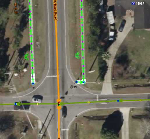
Because of the way the sidewalk there is mapped, it isn’t possible to use for that route. If you zoom in to the intersection of Pritchard and Old Plank you will see that there is no crossing or other connectivity for the router to get from Chaffee Road to the sidewalk.
Yes. If you look at a better mapped intersection you can see how a router might send someone from the road to the sidewalk using a “crossing” line. Technically the contributor who added the sidewalks didn’t do anything wrong, but they left out this key feature that enables routing connectivity. ![]()
You can fix it yourself without too much effort! I recommend clicking the “edit” button and following the tutorial for the online editor at osm.org. Or, if you really don’t want to, you can ask me or another contributor to fix the issue.
brouter.web also produces a similar route. I believe it is because when you look at the underlying data, the sidewalks alongside Pritchard Road just stop at their southern extents without being connected to anything else in the routing network. You should be able to edit the data in your preferred OSM editor. Based on what I saw from the aerial imagery used with the ID editor there is at least a missing E-W crossing between the Pritchard road sidewalks at the southern end
Edit: Snap, looks like Xvtn answered whilst I was writing my reply
Also keep in mind that for cycling directions specifically, depending on the routing algorithm Pritchard road and its sidewalks still may not be used in that scenario, even if the sidewalk is connected with a crossing. A router may prefer to keep cyclists off of sidewalks and larger roads, instead sending them down the cycle path nearby. If you think the direct route is better for a cyclist, you may try adding tags to it to specify bike lanes, shoulder, smoothness, etc. (Of course, only those that are accurate!)
Thanks to everyone for the input and education. I will try learning to add the required information. It is interesting that Google Maps when using the same endpoints does provide the expected routing for both bicycle and walking. This will be a good exercise for me. The path down Old Plank is what I would term a “death wish” for bicyclists as traffic there is 40 to 50 mph with just a slippery grass slope to go down. I tried the ride and had to stop and descend the slope numerous times because I had traffic backed up behind me that didn’t have room to pass.
I’m just curious. What are you referring to by “southern end”? Where Pritchard crosses over the Baldwin Trail is is actually an overpass for cars. There is sidewalk on both sides of that overpass that drop right onto the Baldwin Trail. When I use the satellite view on Google maps the sidewalk is only easily visible on the east side of the road due to growth. The city has crews which mow the lawns and I carry pruners as part of my gear as things grow like crazy in Florida which does keep me busy some days. What I see on Google looks a bit older as I have spent more than a few hours making sidewalks passable. Would it help any if I uploaded a picture or two for explanation?
This is the crossing of the Chaffee Road North and Old Plank Road. What is not good is that these paths are not connected to the crossing or the Old Plank Road.
Looks to me based on this Bing background that the path on the west side is continuing, would be good to map that also, that way you likely get a route via Williams Avenue or Grayson Street.
As I study the photo you posted the space between the road and the sidewalk which appears to have a cement surface (bicycle path) is actually at the bottom of the gully between the sidewalk and road which is in reality part of the storm drain system. I will have to take a shovel or other probe out there someday to see if there is actually cement down there. It is all overgrown as a grass surface at this point.