Railway=station as an area?

Thank you @gymate for your work so far.

Please excuse my late reply. This is a complex issue that requires enough time to think about. Now I have finally found the time.

As there is a lot of discussion here to read through, I will comment on single posts and the questions where you mentioned me later.

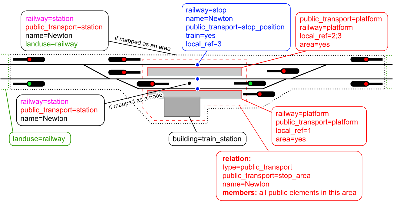
First some general information about mapping stations as nodes vs. areas and why I preferred nodes in the past but now think that areas are the better solution:

The area of a station differs significantly depending on whether you look at it from the perspective of public transport or railway operations. In addition, every public transport station is a train station, but not the other way around (e.g. freight stations). A public transport station includes the platforms, the station building, and overall the areas that are accessible to passengers. The railway infrastructure differs from this: the station building is irrelevant here, but the station area may still include yard tracks, signal boxes and engine sheds. The station is defined by certain signals and switches, so that it can be significantly larger than what the passenger perceives as the station.

In summary: It makes sense to capture both views with separate objects in order to be able to clearly distinguish between the two topics (public transport and infrastructure).

In the past we tried to combine both views in a single feature (partly also for backwards compatibility with renderers), but then you end up mapping a node as a compromise to satisfy both views. But this brings new problems like not being able to query the signals of stations because there is no information about the extend of the station. Which then requires workarounds like the railway facility relations.

Today I think the far better solution is to clearly distinguish between railway operations and public transport view and map both as detailed as possible, which means mapping them as areas.

The updated illustrations and wiki pages are definitely going in the right direction and making things more clearer by separating between both views. But I would still have a few suggestions:

Facility relation

I would suggest abolishing railway=facility. We (mainly Nakaner and I) introduced this at the time in order to be able to map stations as points on the one hand and to be able to do queries such as ā€œwhich station does this signal belong toā€ on the other hand.

railway=facility never really caught on because mapping it was time-consuming and there was no application back then that used it. Iā€™ve actually never really used it myself, too. But the main reason might be that the tagging design was bad:

  • I agree with some other comments here that mixing railway=facility with public_transport=stop_area was not a good idea. This resulted in complex and confusing tagging like type=public_transport + public_transport=stop_area + railway=facility for passenger-stations and railway=facility without any type=* for non-passenger stations (by the way impossible to create intuitive tagging presets for that). It also resulted in mixing public transport members such as stop_positions and subway_entrances with features such as the landuse from a railway operations perspective.
  • The facility relation duplicates a lot of tags of the railway=station feature.
  • The facility relation maps one real world feature as two features in OSM, which is not a good practice.

Now with the recommendation to map railway=station as areas (for the infrastructural boundaries), I no longer see any need for the workaround with railway=facility and propose to deprecate it. It is just redundant information because the information is either already mapped at the station area or can be queried with a simple geometric query without having to maintain a relation and manually adding each signal (can be a lot in bigger stations).

Landuse

Tag:railway=station - OpenStreetMap Wiki suggests:

Do not tag the station area with landuse=railway as this is already implied by railway=station.

It seems illogical to me that there is no land use within the station boundaries, but outside there is. For me it appears a bit like ā€œyou do not need any landuse=residential if there are building=detached because they implicate landuse=residentialā€.

I would avoid such implications as they make using the data difficult. It is necessary to know such rules when rendering a map. And instead of considering just all features with landuse=* to render a landuse map, it is necessary to also consider stations features.

I would prefer to add landuse=railway` at the station area.

local_ref

I would suggest to replace ref=* at the platforms by local_ref=*. This reflects the local character of this id in contrast to global or operator wide identificators in ref. Would also be more consistent to use local_ref both at platforms and stop_positions as it contains the same data.

Backwards compatibility

A problem I see is the compatibility with existing data users, for example OSM Carto. OSM Carto renders railway=station, but should better use public_transport=station instead to avoid the known problems with unexpected labelling.

3 Likes

I hope my previous post describes the thought process and answers all questions regarding railway=facility.

railway=site was used for all kinds of ā€œstationsā€ which do not fit into the other categories (yard, crossover, junction, service_station, halt, station): subparts of stations (ā€œBahnhofsteileā€ in Germany), interlockings securing movable bridges (ā€œDeckungsstelleā€ in Germany) or manual block posts between stations (ā€œBlockstelleā€ in Germany).

railway=site should not be confused with type=site.

Yeah of course, no worries! Thank you very much for your reply.

I agree!

Yeah, it would be a good idea to use the local_ref key for railway station platform letters (e.g. in Slovakia and Czechia) or numbers (at most places).

Yeah this would be much easier, but is there a query to download only the elements of a single station where it overlaps (or is overlapped by) another one? E.g. the RER station Charles de Gaulle ā€” Ɖtoile on layer -5 which is overlapped by MĆ©tro 2 on layer -3? Because this query for the elements of the RER station also downloads the tracks of MĆ©tro 2 (when it works) which could lead to duplicate reference numbers.

Currently this is a rare occasion as most railway=stations are mapped as nodes, but if most of them were mapped as areas, this would be much more common.

Hi,

in general, I recommend to first look only at ways and then split by
level. You can then get level by level going through the numbers

way(680443640) ->.searchArea;
way(area.searchArea)[level=-5];
out geom;

If you wonder how to get the numbers in the first place then you can use

way(680443640) ->.searchArea;
way(area.searchArea);
make info level=set("{"+t["level"]+"}");
out;

If you want to edit the data then you could use

way(680443640) ->.searchArea;
way(area.searchArea)[level=-5];
(._;>;);
out meta;

but the caveats of Sparse
Editing

apply. Another approach would be to download full data and use the JOSM
level filtering instead.

Relations and nodes are insofar of lesser interest here because they
usually do not carry a level indicator.

1 Like

Thanks, I didnā€™t know about this! The query results in the following XML element:

<info id="1">
    <tag k="level" v="{-2};{-3};{-5};{}"/>
</info>

Soā€”as far as I understandā€”this only shows which layers (or in this case, levels) have any elements that are covered by the search area. It doesnā€™t say which layer is the railway=station on.

And this one only works if you already know the layer number of the station.

So, I guess, the solution is to

  1. download all railway=stations in the desired area
  2. get their layer=* (e.g. using Python)
  3. run a new query to download all elements that
    • are covered by each railway=station and
    • are on the same layer=*.

This means that a query for all 872 railway=stations in the world currently mapped as areasā€”which is roughly equal to the number of stations and stops (806) the Schweizerische Bundesbahnen has altogetherā€”would be 6843 lines long.

This canā€™t be run in a browser calling overpass-api.de because it produces an URL thatā€™s too long for the server (Error 414). But it can be run using overpy in a Python script, for example. (It takes an average of 1 minute and 40 seconds for the server to respond.)

So itā€™s possible, but I think that a built-in Overpass API feature would be nice to make this easier.

I agree with this one too. Iā€™ll update the illustrations accordingly.

Here it is:

@rurseekatze Please let me know if I have misunderstood anything.

1 Like

Sweet, succinct. Two thumbs up, A+, making an ā€œOKā€ with two thumbs and forefingers. I nod my head.

Iā€™ve added two missing train=yes tags and updated both illustrations.

I corrected the instructions for adding labels to areas and multipolygon relations on the railway=station Wiki page. I tagged the following stations accordingly:

I also added these to the Wiki as examples.

And Iā€™ve opened an issue on GitHub regarding OSM Carto rendering railway=station labels twice.

Iā€™m a bit confused by the Carto issue. As a station should only have one railway=station object, it seems like a good thing that Carto renders two labels where there are two objects, as mappers are more likely to realise there is duplication.

I am also a bit concerned that the page is moving beyond clarifying current practice towards prescribing a new approach. It now gives high prominence to railway=facility which is rarely used in some (most?) countries. It now reads almost as if it is compulsory.

Thanks for the heads-upā€”Iā€™ve removed all references to railway=facility from the railway=station Wiki page as agreed above.

Iā€™ll also mark railway=facility deprecated on its Wiki page, if you agree.

1 Like

Itā€™s not intended as a duplication but as a correction to the rendering location of the label in the area (to avoid issues like these):

But @Kovoschiz, please correct me if I misunderstood your suggestion!

@imagico Also expressed his concerns on GitHub about using type=label relations and label members on multipolygon relations:

type=label has 51 uses on relations and the documentation indicates it to be intended as a map drawing vehicle rather than a method for documenting geographic information.

Nodes as members of multipolygon relations are undocumented and used rarely (<10k of 36.5M relations). I am not aware of any data users that interpret such.

I donā€™t see any documentation of railway=station having a different meaning when tagged on:

  • nodes
  • polygons
  • nodes that are member of a relation of some type

Is there a de-facto difference in meaning between these different types of use?

Is there agreement among mappers that the examples of double mapping linked to above are correct? That would seem odd in light of One feature, one OSM element - OpenStreetMap Wiki.

@Kovoschiz Could you please share your thoughts on these too as an experienced mapper? Thank you in advance!

Speaking only for myself, I found the mapping of Kimle-KĆ”rolyhĆ”za quite surprising. It wasnā€™t where I thought the previous discussion was leading. We now have two objects that repeat almost the same tags including railway=station and public_transport=station. How would mappers know which one belongs in a stop area relation, for example? Note there is also an ongoing discussion on this forum about removing duplicate railway=station which informs mappers that there should be strictly one of these objects per station: Maproulette challenge: Fix duplicate railway stations [looking for feedback]

Also, I feel it is unclear whether you are asking for rendering specific to train stations or more generally. Is there any reason to treat stations differently from hospitals, shopping centres, or universities?

Given the low usage of type=label and the fact that the only documentation seems to be a proposal from 2008 that went no further, I would say it is going to be difficult to get this type of relation rendered.

I think it is rather different from the administrative boundary situation, where it is not quite true to say that the Chicago label is only rendered once - the label also appears alongside the boundary line if you zoom in far enough.

Iā€™m confused on whatā€™s happening. I mentioned label as one possible option to replace the railway=station point if an area is not enough. That may not be needed if areas are accepted.

Iā€™m sorryā€”I misunderstood your suggestion.

So how could we tackle issues like these?

So how could we tackle issues like these?

(Berlin Hbf), this is only a part actually, the station is composed of 2 parts (5 floors lower there is the north/south line)

1 Like