The railway= tag is used to map the trackbed geometry, just as the highway= tag is used to map the geometry of what Americans call “pavement”.
railway=railmeans that there is an active railway on the trackbed.railway=disusedmeans that there is a disused railway on the trackbed (rails still down, no trains run).railway=abandonedmeans that there is no railway on the trackbed, but that the trackbed is still extant. This is the standard tag to use for rails-to-trails cycleways.railway=dismantled(orrailway=razed, they’re synonymous) means that the trackbed is no longer extant but that the former presence of a trackbed is still an observable fact worth mapping.
The canonical example near me is Hook Norton Viaduct:
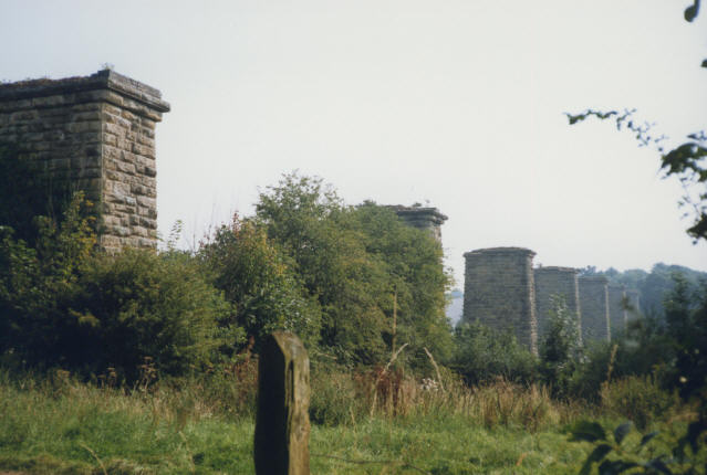
(photo by Stephen Craven from geograph.org.uk, CC-BY-SA. More photos of the viaduct: Photos of hook norton viaduct :: Geograph Britain and Ireland. It’s really quite something!)
The trackbed here, made of iron, was removed in the 1960s after the line closed. The pillars remain. As a result, the individual pillars are mapped with historic=ruins and the line connecting them is mapped as railway=dismantled. The latter gives context and meaning to the former, showing that the pillars were built as part of the railway and therefore have a design and construction appropriate to that.
That this structure is a railway structure is an observable, documentable fact. I grant that an ancient people could have come along and built the pillars as part of some sort of mysterious Stonehenge-like ritual, in praise of the Prophet Ba-Ron B’Ching. But until we have any evidence for that, railway=dismantled it is.
There are lots of examples like this, where a bridge deck has been removed but the abutments and (often) pillars remain. This is the core use (in my view) for railway=dismantled. I am not going to man the barricades for people who use it across ploughed-up fields. But then, I haven’t surveyed those fields and it’s possible there are details I haven’t seen, so nor am I going to delete it. (I would be a bit miffed if someone deleted the obscure bits of the former Oakham Canal which I spent my 20s traipsing around fields discovering, just because they can’t see them on Bing imagery.)
Incidentally, I wonder if TNS-MN's Diary | OSM Leave of Absence | OpenStreetMap is connected with this episode. If so that’s very sad - it looks like we may have lost a good contributor with local knowledge.