I think we were starting to consider it as a boundary=place, which skirts this issue entirely. But if we keep it as boundary=administrative, then I don’t see why not.
To clarify, I definitely think there should be an admin_level=6 boundary consisting of San Francisco. I think there should also additionally be an admin_level=8 boundary, or something that denotes both levels, as I see no reason why it has to be just one or the other. But if I had to choose, I think 6 alone is better than 8 alone, in large part for the reasons @Minh mentioned.
Again, there is no sense in which “Washington” is any kind of administrative boundary. If we want to make one up, I don’t think it matters much which level we set it at. I suppose it depends if you want to lean more into “Washington is perceived as a municipality” or “counties should be space-filling”, neither of which really apply in the District due to its unique status.
1 Like
This is true of certain maps, like the classic atlas/road maps you posted, but I’m not sure it’s exactly true in general. Some maps do care about the territory’s designation, not just how deeply nested it is. For instance, here are two maps of the Bay Area:
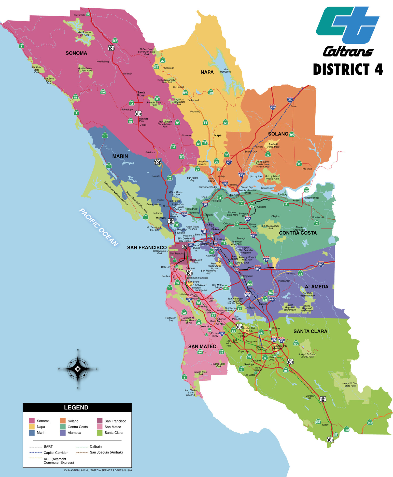
The first is a map by counties, defining the fairly typical “nine-county” area. The second is a map of incorporated cities of the Bay Area (and extending a bit further afield). I guess my thoughts boil down to thinking that both maps should be possible to create with OSM data alone, and that both match the common understanding of the administrative divisions of the area.
As a demonstration: the second map was actually made with OSM data, as described in detail here: Blueschisting. I note it would actually no longer be possible to create this map following the site’s instructions with current OSM data, since this was made before San Francisco’s admin_level=8 boundary was deleted. Now you’d have to special-case San Francisco to reproduce it, which I guess is fine, but I don’t see why one would need to when we could just have both boundaries. OSM data is also why Morgan Hill and Atherton are missing, they weren’t added as admin_level=8 boundaries until 2022 and 2019 for some reason.
1 Like
True, what we’ve done has broken backwards compatibility for maps that intentionally focus on incorporation. I’d think that such maps are more likely to be U.S.-specific or even state-specific, since you couldn’t even port that map’s pipeline to Maine and still call it a map of incorporated places. Replacing admin_level='8' with border_type IN ('city', 'town', 'city;county') doesn’t seem like a tall order, as long as extracts from Geofabrik expose border_type=*.
The most popular vector tile schemas, which have global scope, don’t expose border_type=*. If this turns out to be an issue, San Francisco, Denver, New Orleans, and Washington would all be powerful examples in favor of adding a field for this key.
“Washington” and “DC” certainly existed as separate entities in past history, and there were subdivisions of the District in the earliest days.
There were even counties, and unincorporated areas of the District!
As we all know, the Virginia side was given back, and the city of Washington eventually subsumed DC in its entirety. I don’t see how this situation is different from Orleans Parish / New Orleans.
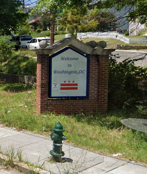
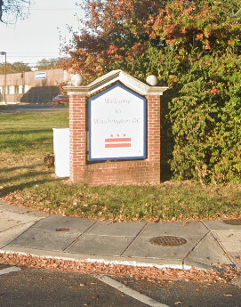
If we’re getting into this level of detail, Washington, D.C., is even weirder than the other cases. Wikipedia notes that, in law, the City of Washington still exists as a legal jurisdiction with the same boundaries prior to consolidation – that is, not coextensive with the district. It just doesn’t have a government of its own anymore. In practice, everyone treats the city and district as being coextensive, as the welcome sign illustrates. The de jure city is like one of Ohio’s paper townships: definitely extant but way too obscure and surprising to map as an administrative boundary. The most accurate way to model that Washington is de facto coextensive with the district is to map it as a boundary=place relation.
2 Likes
I think this is potentially fine, and consistent with how Honolulu is mapped (by me). The City and County boundary gets the whole county area, while the city itself (which is customarily defined as the area between three specific volcanic ridges but has no government) is mapped as a boundary=place.
So then, do we have agreement that the way places are signed is the most important discriminator?
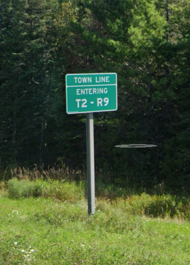
We mapped these numbered Maine townships as admin_level=8 administrative boundaries despite the lack of a government. But, they have signs!
In the D.C. case, there would be two coextensive boundary relations: a boundary=place place=city for Washington and a boundary=administrative admin_level=4 for the District of Columbia. Some geocoders may consider the two boundaries to be tied in prominence because of their equal areas. The assumption is that they’d break the tie by considering any level-4 boundary to contain any non-administrative place=city, which I think is generally the case among geocoders.
Incidentally, Nominatim currently considers the Washington place node to be at level 2 because someone added admin_level=2 to a variety of places across the western hemisphere back in 2012. I think this was just a misunderstanding: the admin_level=* documentation says it’s sometimes used on nodes because of office=government, and also mentions that the same numeric scale is used for capital=* on place nodes, but I don’t think this means capital city place nodes are supposed to have admin_level=* on them. Any idea if there would be a problem with removing it from Washington?
This is a good rule of thumb in the U.S., especially since border signs seem to reliably quiet any criticism of boundary mapping on verifiability grounds. However, I wouldn’t elevate border signs to the sole determining factor. If we need to boil it down to a test, I think it would need at least two prongs. A given administrative subdivision is mappable as boundary=administrative if:
- The competent government authority acknowledges its existence as part of the primary scheme for subdividing its territory; and
- It communicates the location of the boundary to the public for the public’s day-to-day use.
Signs and markers are the traditional tools for communicating the location of a boundary, but they aren’t the only way we know about boundaries. After all, you wouldn’t expect the State of Hawaii to mark its state or county borders with border signs. Nor does every city along the Mississippi River feel the need to post its city limits at the riverbank. Within a city, there are lots of diverse approaches to informing residents of neighborhood boundaries, sometimes inconsistently. Which leads to a slight qualification on the second prong:
- It communicates the location of the boundary or others like it to the public for the public’s day-to-day use.
So if Maine signposts the boundary of each of its townships except for one, for some bizarre quirk of politics, but it still begrudgingly acknowledges the township’s existence in other ways, I think that township boundary is still mappable. Most of the consolidated cities strain this approach, because they’re in a special class as far as the state is concerned, so there isn’t any “others like it” to go by.
1 Like
I did a quick survey of signs on the DC border:
Rhode Island Ave, From Maryland:
Bladensburg Rd, From Maryland:
Wisconsin Ave, From Maryland:
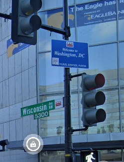
From all examples I can find, the name is cited on signs as “Washington, DC”. So it seems like the boundary of “Washington” and “DC” is clearly signposted – or, the boundary of “Washington, DC” is clearly signposted.
Yes, as I noted earlier, the District of Columbia calls itself “Washington” or “Washington, D.C.”, in some contexts, including on its welcome signs. (Not the “City of Washington”, though, that’s just a legal quirk for the library stacks.)
And if you go to one of these signs and do a 180, you’ll see one of these signs, marking the boundary of a census-designated place. Not every boundary is administrative.

I realize that this phrasing may cause some confusion:
In my view, the competent government authority in this case is the federal government, acknowledging the states, the District of Columbia, and various other territories as being the primary scheme for subdividing the territory of the United States. In the case of San Francisco, the competent authority on how to subdivide California would be the State of California (which ruled on the matter). In the case of New Orleans, the competent authority on how to subdivide Louisiana would be the State of Louisiana (which put up the parish limit signs and labels the parish on official maps). In the case of the various parts of Connecticut, the competent authority would be… ideally the State of Connecticut, but it’s currently the White House Office of Management and Budget for reasons we can debate elsewhere.
Do we see a problem with mapping Washington as a space-filling place that is de facto verifiably coextensive with the boundary of the District of Columbia?
1 Like
That sign looks to be put up by “Bethesda Urban Partnership, Inc.”. Hardly the cognizant goverment authority, so I don’t think that’s a relevant counter-example.
I think this is fine because both are in use and there’s a clear distinction between Washington the city and DC the federal district. I am more interested in the general rule that we’re applying to make sure it works as well as possible in all places we’re applying it.
Generalizations entail compromising on reality, but we normally focus on mapping reality, leaving the generalizations to data consumers. When it comes to boundaries, I think we have to be careful about defining general rules and especially about overextending them. That’s what got us involved with this thread in the first place, taking the Census Bureau’s generalization at face value. I’m happy to continue refining our rules of thumb, but they are just that – rules meant to be broken when we’re faced with new facts.
Our wiki mentions (in early footnotes to US admin_level) that the Census Bureau “sorta” does this as it gloms DC into a county equivalent. It isn’t (in reality), but it is “convenient” that under certain circumstances our Commerce Department does this. Our wiki explicitly say OSM chooses not to. That’s at least something (that clarifies, and says “bureau does this, OSM does not.”)
So, “Washington, D.C.” is, as our wiki (in United States / Boundaries) says admin_level=8 and admin_level-4, respectively. This is in a section called (I believe Minh-titled) “Notable Exceptions.” I’ve been OK with this, I’m glad to see us talking about it and heads nodding (or continuing to nod lightly). Fully nodding? Unanimously nodding? Well, we’re getting there.
So to sum up, no, that logic says that we don’t “promote” the nation’s capital to admin_level=6. The bureau might (and does, for certain purposes), OSM doesn’t. And we say so. And heads have been (at least lightly) nodding for some time about that.
Does DC “go straight from 4 to 8?” Yup, it does. It’s odd, but it’s explainable; we do explain.
At least originally, this page was intended to be nothing more than a description and explanation of current practice in the database – a “basic tagging guide”. Nothing is set in stone; in fact, there may be a lot to update as a result of the discussion and discoveries in this thread.
The edit summary that accompanied that early revision: “There be dragons.”
4 Likes
The census bureau does list a single county sub-division in DC. And in this case, the Federal Government does happen to be the competent authority ![]()
https://tigerweb.geo.census.gov/tigerwebmain/Files/acs24/tigerweb_acs24_cousub_dc.html
The source of this information – Census Bureau’s 2024 U.S. Gazetteer Files – says the District of Columbia is a state that contains a single county, also named the District of Columbia, which in turn is divided into a single county subdivision, Washington city, which is also a place. In other words, this is a city in a consolidated county–state, not a consolidated city–state.
Taking this information at face value, there would be three coextensive boundaries:
boundary=administrativeadmin_level=4border_type=districtname=District of Columbiaboundary=administrativeadmin_level=6border_type=
name=District of Columbiaboundary=administrativeadmin_level=8border_type=cityname=Washingtonofficial_name= .
There you have your answer as to what the admin_level=* would be for Washington, but it would raise other questions and headaches.
To clarify, I was saying (the body of laws of) the federal government is the competent authority on how to divide the U.S. directly into second-order subdivisions. Ideally, this would be something, you know, authoritative, in law, rather than a statistical geography program that has to worry about making the numbers work out. That program routinely fudges the names of things for convenience (including many of the paper townships in Ohio). But regardless, it’s widely acknowledged that the District of Columbia is one of the second-order subdivisions of the U.S.
Meanwhile, the competent authority on how to further subdivide the District of Columbia would be the government of the District of Columbia. Going back to the top of this discussion, what we’re mapping isn’t the government per se, but the government’s view of how to divide its own territory does carry some weight. Yes, that government is technically an arm of the federal government, but whatever. Do they seem to promote the idea of Washington being a municipality within the district? What is its official name? Surely not the City of Washington, that obscure legal remnant which would exclude a good share of its residents.
No, under federal and local law, the District of Columbia is divided into wards and neighborhood council areas, in much the same way that other admin_level=8 cities are formally subdivided into electoral districts and admin_level=10 neighborhoods:
The Council shall by act divide the District into neighborhood council areas and, upon receiving a petition signed by at least 5 per centum of the registered qualified electors of a neighborhood council area, shall establish for that neighborhood an elected advisory neighborhood council. In designating such neighborhoods, the Council shall consider natural geographic boundaries, election districts, and divisions of the District made for the purpose of administration of services.
We don’t need to get into whether these wards or neighborhood council areas are mappable as administrative boundaries, but it seems that, at least officially, no Washington has been inserted in between the district level and the neighborhood level. The Washington we all know is a place, and a name for the district, but not a separate jurisdiction.
1 Like
WDC is unique, it is a consolidated federal-district-city. From that, and how it has been (regardless of what our Department of Commerce, our employees who we tell what to do and how, as we the People are the competent authority), I get 2-4-8. Yes, 9-10 data have grown in OSM over the last several years, too. But “it” is a 2-4-8 stack of data. If the Bureau (and others in OSM) want(s) to add a 6 for convenience, it’s only for that, not as legal fact of de facto government and its administration. I’ll stick with 2-4-8. If we want a 6, OK, but tag that what it is: a boundary=census.
A gazetteer file we pay our employees to publish? Being authoritative? Pah. Let’s stop pretending the Census Bureau is authoritative, it is not, except for boundary=census and its ilk.
Minh, the answer to your first red question mark is border_type=census for now (if you MUST have one, and we don’t), as I think a (simply, sole) boundary=census works to denote the boundary even better. It’s “only” a boundary, it isn’t the extent of a (multi)polygon tagged admin_level=*.
We keep getting closer, I like.
I’ll go one further: how does a Census Bureau gazetteer for the purpose of statistical data summarization overrule an act of Congress and the District’s legal code?
1 Like
Thank you. Hopefully we can agree then to restore Connecticut’s counties to admin_level=6 and undo the planning region nonsense, which is a census bureau statistical fiction that we chose to map in the administrative boundary scheme.
That would be incorrect on its face. boundary=census is used for CDPs, and there are no CDPs in the District of Columbia.
Just to sum up the current score for anyone keeping track at home, at present, @Minh_Nguyen is advocating that Washington is boundary=place and @stevea is advocating for boundary=administrative + admin_level=8 but definitely not admin_level=6.
If indeed Washington is administrative, it’s unclear to me why nearby Falls Church, VA, which is also not in a county, gets admin_level=6 but Washington would be admin_level=8. Of course, if Washington is merely a boundary=place, this question is moot.
== Useful links below ==
Because this seems to be lost considering the suggestion to tag a CDP, the census bureau products I’ve been reviewing are linked from the state-based data files list. This includes the following products:
The latter two products mean different things in different states, so you have to decode the codes in the various columns to properly interpret what the census bureau means by each of these things. For example, in Rhode Island (and I suspect space-filling boundary states generally), the “county sub-divisions” list contains a complete list of incorporated places while the “incorporated places” list (confusingly) only contains cities. Whereas, in other states, the county sub-divisions include entities that are pure statistical divisions (CCDs – different from CDPs.)