I propose a community to discuss and consider cultural similarities and differences acrs cultural spheres when editing and contributing to OSM.
There are differences as well as similarities between each culture.
Their differences and similarities are not based on national borders.
In my opinion, OSM and the nationally divided OSM community are unfortunately flawed in their ability to clearly reflect and take into account these similarities and differences. The division by country is not the problem, it means that it fails to consider cross-country cultural factors. So, to compensate for that, I think a new community is needed for discussions between cultural spheres.
Therefore, rather than focusing on a specific country with a large number of contributors, I believe that culturally specific communication is needed to more clearly reflect cultural similarities and differences.
To add a bit more, while policies may vary by country, the nature of cartographic features is culture-specific, especially when it comes to historical landmarks.
So I think it’s better to talk about it in terms of cultural backgrounds rather than just geographical continents, and that’s why I’m proposing to create a new community.
My terrible English prevented me from telling you all about the need to create a new community.
I understand that some people may question the need or utility of a new community.
I respect those opinions, and if you have any further questions or need clarification, please feel free to ask me or we can discuss it together.
There will be many grammatical errors because I wrote this article relying on my terrible English skills and machine translation. Please accept the big meaning rather than the small expression.
Please be considerate of users of other languages and write your comments in plain language.
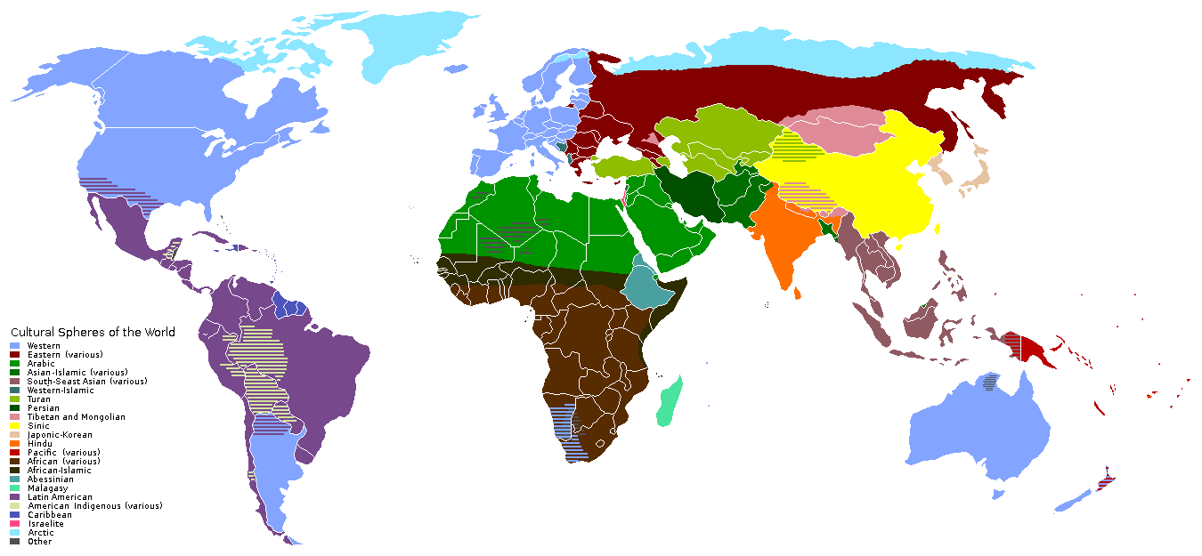
this is quite questionable in various points, (apart that the granularity of “western” doesn’t seem to correspond to the differentiations in east asia), e.g. Iran is in a different circle then Iraq, or Greece, Romania, Bulgaria are in the same sphere as Kamchatka, and not “western”. There are more of these (Africa “spheres” also don’t seem to be differentiated), generally I guess this was done by someone who knew Asia better than the rest of the world.
By the way, there is already a cultural tag which was once introduced for ancient civilizations but which is now also used for more recent cultural spheres (and also for rougher time epochs like “neolithic”): https://taginfo.openstreetmap.org/keys/historic:civilization#values
Regarding this division, we have an OSM Latam, which is very flexible in its definition, and it is composed of many countries, cultures, and ethnicities that share a common history without being very strict in this sense. Any person or group that considers themselves part of LatAm is welcome to this group.
We have discussed things that cross many countries and are the same in the region, like trees, rivers, and roads. One example is Mapazonia, a map of the Amazon River. Also, by working together, we have done many works together, like Note Resolution, which many LatAm countries are concerned about (https://resultmaps.neis-one.org/osm-notes C/O ratio). Also, we used to do State of the Map events. Finally, we have a group to work on a risk management map to deal with all the natural disasters that hit the region.
In conclusion, working as a region has strengthened our local communities, and we have discovered things from our country’s neighbors to work together for the map.
I consider it more appropriate to invite anyone interested in LatAm. One can be interested in mapping a certain area of the map without needing to consider oneself “part of it”, whatever that means.