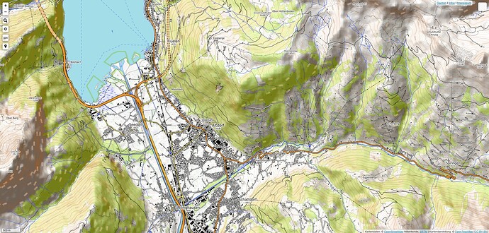
Proposal: add contour lines and hill shading to the default map

Hi everybody,

I am regular user of OSM and occasional contributor. I am not in the position to “request” anything (inappropriate anyway at OSM), and technically, I do not know much about the deeper mechanisms, but I would like to suggest some additions for the main map displayed at https://www.openstreetmap.org.

Basically I would propose the addition of
1. Contour lines
2. Hill shades
The result should look like a mixture between the current default layer and the OpenTopoMap.

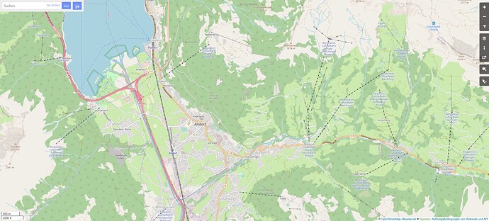
I know that OSM is not a map (only), but a database of geo objects. Nevertheless, we should expect that most people have their only contact with OSM through the default map, hence the map should satisfy a general purpose, like outdoor planning and getting a first impression from a geographical area. I have observed that I often consult alternative maps as the “flat” default map does not satisfy my needs.

The proposed additions are most prominent where the terrain is steep, hence the probability is high that there are not many other features in the map (like buildings, streets), therefore the proposed additions would not clutter the map too much and distract from existing content.

I know that hill shades and contour lines are not part of the OSM project and have to be pulled and implemented from other sources (as it is the case already for example in the CyclOSM layer).

It seems that there have been deep discussions about the purpose and aim of the general map, but I do not want to trigger a fundamental discussion.

I would handle it pragmatically and just improve the style. May be, there could be an evaluation phase: an “enhanced” version of the map is added as additional layer. Using some site analytics (if possible at all?) could help to determine which style is used by the users more often. Depending on the result, one could introduce a new default style.

An alternative approach would be to have additional overlays (similarly to the GPS tracks that can be switched on and off).

I am coming forward with this proposal as I feel that the current map style is not taking full advantages of an open source map, and that the map is not attractive enough for a typical use case.

To get a first idea about the opinions present, we could have an informal vote here.

  • No, keep the default style as it is
  • Yes, please add hill shades and contour lines
  • May be yes, but in another way (welcome to comment).

0 voters
I think this was covered and rejected in issue #2931 of the main styles Github issue tracker. There’s also some other issues related to it there if you search for “contour.” Not to be a negative Nancy, but I doubt a straw pole in a random forum post will change the status quo. Posting a comment on Github that voices your support for the idea and says why you think it’s worth doing would probably be a good idea though :+1:

osm.org is the most prominent visualization of OSM data. It should not include data of third-party sources for (at least) two reasons:

  • This would be false advertising
  • New users would be confused why they only can edit part of the shown data with the edit button
9 Likes

You are rigth in principle, but I would plea that in most cases it is not an issue:

  • New users only care if the map is useful and if it gives a realistic representation. Infomration about slopes and elevation is very relevant information. New users do not care if it is “false advertising”. They just conclude that it is a strange, flat map and will never return. Experienced users and mappers know what to edit.
  • I do not think that users will try to edit elevation data. Why would you like to do this? What would be your data source?

After all, users do not care about principles, they are attracted by good maps. And a flat map is not attractive if it is the first thing you see on osm.org.

2 Likes

Yes, hillshading and contour lines are very important in the hills and mountains (and not interesting in many flat regions), but as they aren’t data we are collecting, for our showcase default map it isn’t necessarily helpful (one might argue that the data we do collect can be better understood with the terrain as a context, and I’d agree to it). I’d keep the default map “simple” (focused on our own data) because our strength is detail (where mappers are) and in detailed views, the commonly used (“globally” available) 30m or 90m elevation grids are not sufficient.

On the other hand I also miss hillshading for checking out walking navigation on the website or to browse with the terrain context, and the two bicycle oriented maps are not perfect if you do not want to focus on cycling (naturally). There is waymarked trails which is very recommendable and while not reachable from osm.org you can go directly to their site if you know about it (not sure if @lonvia could be interested in eventually getting a traffic boost from being integrated on osm.org home?) — the hillshading is a separate overlay layer that you can activate (could this be an option for osm.org?)

2 Likes

I saw maptiler’s 3D rendering and thought that would make a good addition to OSM.org. It could be used as a starting point for vector tiles as well. As in, here’s a 3D version of the default rendering but it comes with the compromise of not showing everything that OSM-carto shows.

Both the existing CyclOSM and OpenCycleMap layers include hillshading and contour lines. Would this satisfy the outdoor planning use case you have in mind? If you find something missing in these layers compared to the Standard layer, perhaps you could leave some feedback in the CyclOSM issue tracker or contact OpenCycleMap’s maintainer, @Andy_Allan.

2 Likes

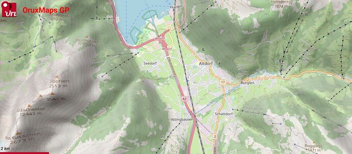
It should look similar to this. OpenStreetMap + MapBox Contours + MapBox Hillshade combined in a .json style for OruxMaps.
Although it was already explained why the OpenStreetMap map should be kept as it is, it would be a good idea to add a couple of layers (Contours and Hillshade) to both OSM ID and to the main OSM site.
It could be added as a separate list of sources to activate on the OSM tiles.
Likewise, if OSM ID allowed the mixing of a basemap and a layer it would be quite useful to map certain elements that require a better visualization of the terrain.

4 Likes