The core paths data for Scotland is now available under the Open Government Licence as GeoJSON and a shapefile.
What’s the best way to compare this with OSM data, to add the designation tag to the existing OSM paths? (I imagine most if not all already exist as paths in our data.)
Take OSM highway network (some core paths may be along tracks, service or unclassified roads, or worse, the Kintyre Way follows the B843 for quite some distance : it might not be busy but traffic is fast & there have been pedestrian fatalities). This may (just) be doable with Overpass (but not Overpass Turbo: A-roads are 30 Mbytes). Make sure the designation tag is available.
Read it into QGIS, and create a new layer transformed to the OSGB projection (27700).
Buffer the OSM highway network by some arbitrary value. (I’d use from 10 to 25 metres: it depends on how accurate you expect OSM to be).
Load the core paths file.
Step 1: find all core paths NOT within the buffered OSM highway layer
Step 2: find all within the buffered OSM highway layer
Filter the OSM highway layer by designation
Step 3: repeat step 1 with results of step 2 and the filtered OSM highway layer
Step 4: for completeness find all those core paths accurate tagged on OSM (basically repeat step 2
You end up with 3 useful layers: from steps 1, 3 and 4:
Core paths missing entirely
Core paths mapped, but missing designation
Core paths mapped with designation
The steps can be quasi-automated and saved as a workflow in QGIS which allows the process to be run with more up-to-date OSM data. Ensuring layers are spatially indexed makes a big difference in performance. In principle you can do this all in PostGIS too, but there are some gotchas which mean there are more steps involved.
7,500 elements not mapped on OSM (this probably includes paths mapped but greater than 20 m discrepancy in parts (e.g. Kintyre Way S of Ballygrogan on the Mull). Comparison based on old OSM data (so it picks up the non-path along Machrihanish Beach)
If I were to make a pedestrian centric map, I’d probably start with one of the existing cycling renders (CylOSM for example) and adapt it from there to render sidewalks and walking paths rather than bike lanes and bike paths (at high zoom levels) and walking routes (rather than bike routes) at low zoom levels
+1. It always bugged me how you only use ways to map a road, regardless of how wide/narrow it is. It’s not just a philosophical problem. When the number of lanes change, you follow the centre and introduce a curve that’s not there. This can possibly be confusing.
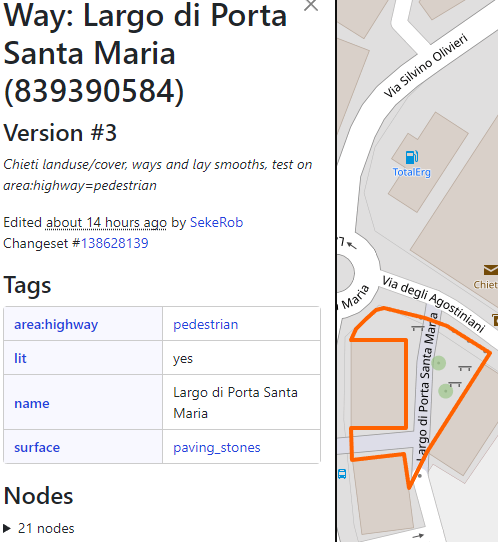
highway:pedestrian + area=yes still including JOSM
Tried area:highway=pedestrian before as I’ve been using that since long for vrs incl traffic islands, motorway toll areas a.o. but somehow it would not stick although there’s a wiki
And then countless not understanding that a way needs to be mapped across or else the navigator software falls flat. “can’t compute” or gives the zone a wide berth and a detour of a half mile stroll.
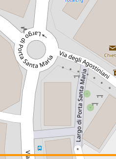
Just tested on something mapped in 2020 and switched the pedestrian area tagging from old style to new style, where the pedestrian streets were mapped to satisfy the routers. Can see the Largo Santa Maria pedestrian streets now.
The fact that (even) JOSM anno 2023 is still presenting old tagging in the standard preset is an indication, but anyway just cobbled another custom preset together for the new style.
I think you might want to use a few more words what you’re trying to say here. You’ve not linked what URL those graphs came from, and not said whether the thing that you’re trying to map is mostly a linear thing (as most streets are) or mostly not (e.g. a pedestrian square).
Personally, I wouldn’t OSM Carto as a reference renderer because of the well-documented issues with it not supporting “new” features. What to replace it with as a reference renderer is a good question, though…
As I understand it, this isn’t a “new” versus “old” thing. I use this rule of thumb:
highway=pedestrianarea=yes for the walkable part of a nonlinear plaza, where you would likely roam in any direction (maybe also highway=footway for the most important paths through the plaza, as a compatibility shim)
highway=pedestrian for a linear pedestrian mall, where you’re likely to go in a particular direction (maybe also area:highway=pedestrian for its 2D representation)
highway=footway for a linear footpath (maybe also with area:highway=footway for its 2D representation)
(Note that place=square technically includes the entire plaza, including unwalkable parts like a fountain or landscaping.)
osm-carto declined to render roads and paths in 2D many years ago, although this was before the project added support for man_made=bridge areas that are sort of analogous.
This topic started out asking about a pedestrian-centric map, which is a good way to frame the issue. As a general-purpose style, osm-carto isn’t anything-centric, but a separate style geared towards the urban walking environment would complement the featured cycling- and transit-oriented layers nicely.
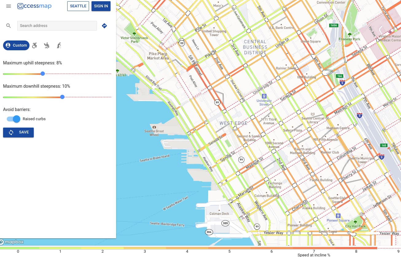
Sorry for a late comment but I just saw this discussion. The University of Washington Taskar Center on Accessible Technology has a demo pedestrian map at accessmap.io. Besides showing sidewalks, it also shows the incline of the sidewalk. For those that are not familiar with Seattle, the downtown is very hilly.
It works well for a city like Passau, marking a grid of links
through the city center that are indeed appealing. Beyond the talk
demonstration, this got no feedback, so got a priority too low to ever
implement it.
In theory I think you should be able to reconstruct this from a Contraction Hierarchies graph. I’ve done some experiments with OSRM’s .level file but haven’t yet got a result with which I’m 100% happy.