Hi,
I downloaded data using Overpass API (both .de and .fr) via XApi compatibility layer. Namely, all south Vietnam data - Mekong river delta. Query was only simple bounding box. Then I imported the data to QGis (with all attributes). Everything looks fine, but:
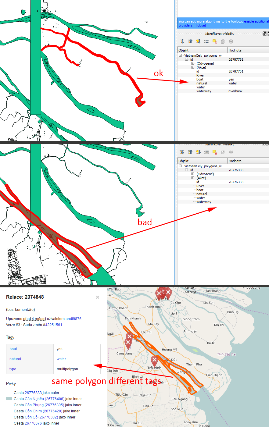
Some river polygons doesn’t have “water” attributes (like: natural=“water”, boat=“yes”, water=“yes”, waterway…or something). Everything is NULL. Although, when I’am looking to the same data using opengstreetmap.org web viewer (with “?” icon), polygons has “natural=water” attributes correctly filled. Note: I have this issue only with some polygons (approx. 5-10% ?), while others are ok - so I think, import settings was correct and problem is elsewhere.
Can anyone help me or explain what is wrong? My english is poor, so I maybe miss something important in Overpass API documentation.
here is it: www.overpass-api.de/api/xapi?*[bbox=104.3828831,8.3792389,109.5025119,12.3231544]
(I can’t use url BBCode tag, because of squre brackets in qurey).
And here is my import process:
add “.osm” extension to downloaded file name
In QGis: Vector > OpenStreetMap > Import Topology from XML
In QGis: Vector > OpenStreetMap > Export Topology to Spatialite
(choose polygons and “natural” tag)
Is it possible that in your “bad” case the tags are on the multipolygon-relation, while in your “good” case the tags are on the way ? (and there is no relation involved)
In the screenshot of OSM you show a relation, but in QGIS you show a way ?
This sounds like good explanation. Some attributes in OSM has “multipolygon” relation, right? OSM importer in QGis will probably break this kind of data…interesting.
Do You have some tips, how to correctly import those multipolygons or convert them to SHP (not necessary to QGis)? Yes, there is lot of links on openstreetmap wiki, but if something is well-tried, I will appreciate your help.
(I’am programmer, not GIS worker, so my question(s) may be little bit stupid…)
OSM has 3 types of objects: node, ways and relations. A multipolygon is an example of a relation. This type of relation is typically used to create objects with holes in them (e.g. river with island inside).
I’m not familiar with importing data in QGIS, sorry. You’ll have to wait till someone else finds the time to reply.
For everyone with same issue: QuickOSM plugin for QGis is able to resolve relations! Now, data looks fine. Thank You.
(The QuickOSM plugin can be installed directly from QGis gui. )