The page would be clearer if it would display which view I’m actually looking at. So please add a title.
Also it would be nice to be able to switch view while zoomed in. Now it zoomes out to the whole world.
Also try to show the three clickable views as a list, not as a sentence.
The nice coloured lines are still a big mystery to me ![]()
2 Likes
Done. You can now have 2, 3, 4, 5, 6 or the original 7 colours.
2 Likes
Done (![]() javascript)
javascript)
4 Likes
when you change the colours, you can see that they are in different groups
3 Likes
A situation that I observed while revising river basins : When a way waterway=river upstream followed by waterway=stream downstream, It could be reported / highlighted as topolocigal error (particiluar color or dots ?).
Its great thankyou
Updates:
- Added a “
waterwaywithoutname” view. - Added the ability to filter all groups by min or max length. It can be slow to update FYI.
4 Likes
The “waterway without name” view appears to be identical to the " waterway & name" view.
I would have expected it to be something like waterways that do not have a name tag
Would it be possible, to add somewhere a time stamp of the last update?
4 Likes
For all interested:
3 Likes
I live by the Fraser River, and I’ve been working on fixing missing connections. We have a lot of cases from CanVec where streams got connected to the water area, not the waterway down the middle of the river.
Because there’s so many, I’ve just been following the river and using this JOSM query: parent ( child (child (type:relation type=multipolygon natural=water water=river) | (type:way natural=water water=river))) waterway=stream -(parent child waterway=river)
2 Likes
It’s very useful, I’ve been doing some corrections, will do every now and then when the tool gets updated data.
Went to ask a lady in the garden on the banks of a long nameless stream I’d mapped last year and it turned out to be the Serepenne flowing into the Fiume Foro, the name making perfect sense v.v. the naming of the area and had a hit on the www confirming serving as a natural divide between 2 communities.
Sort of hoped the stream would now show up as part of Foro river’s ‘watershed’ and bingo, few days later, under the selection of " with waterway & name. Purely topological grouping" it raised the numbers top 86KM, not the Mississippi. :O)))
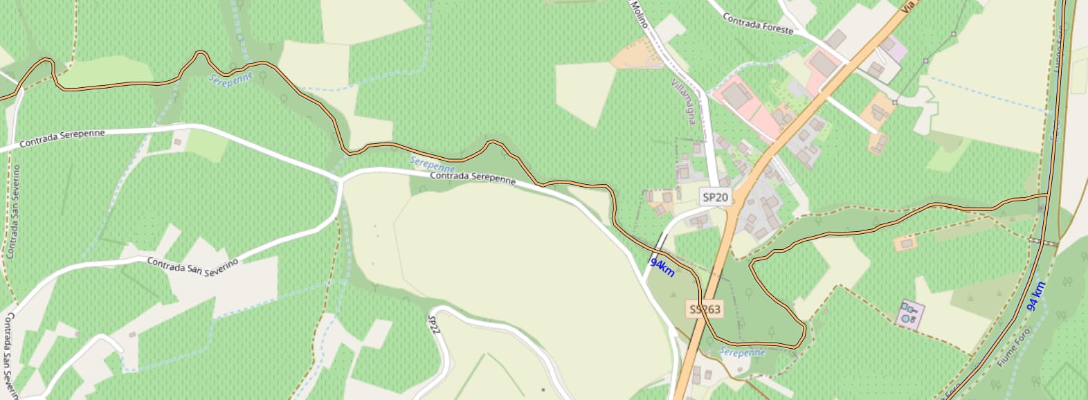
Coowl though.
edit: The calculations worked their way thru a missed name on a stream culvert and now we’re 94KM.
2 Likes
Fixed. Calculating how all the rivers & streams in the world are connected in easy. Updating a webpage when a user clicks a thing… now that’s tricky ![]()
![]()
![]()
![]()
1 Like
Done.
1 Like
spotted on OSM River Basins | Hacker News
4 Likes
I saw this on Hacker News. I noticed a few map problems in Oregon. The biggest is that the Columbia River is disconnected at McNary Dam near Umatilla.
How would I go about edit OpenStreetMap to fix it?
2 Likes
In that case OSM is “correct”, as there is a lock, so that part of the river is in OSM-terms not a river and therefore in the “river-only”-view it’s disconnected. You might want to use the “river and canal”-view instead.
Additional it’s beneficial to set the max length to something like 100km, so the unconnected parts are easier to spot. In general either zoom to the area and click the jOSM button (in case you have jOSM running) or the link to osm.org, in order to edit the area in iD.
Btw. thanks @amapanda_ᚐᚋᚐᚅᚇᚐ for adding it ![]()
1 Like
Follow " This area: osm.org" link just above the map and press edit
Looking at OpenStreetMap it seems that currently main stream of river, not going through lock, is not mapped and this waterway=river section should be added
1 Like
I updated the McNary lock a few days ago (Way History: McNary Lock (163917831) | OpenStreetMap). If someone spots something mistagged that would be great to know about. I followed the tagging guidelines for lock from the wiki.