For Poland there is public/state forest database available as online map with several layers. One of the layer show the type of dominant trees in given area of the forest: Bank Danych o Lasach.
This is very useful for me because knowing pine likes dry conditions I can look after pine areas and in advance target such places as perfect spots for camping (more about it I wrote at Żerowisko – Przypadkopis in Polish).
Now I wonder whether there are such databases and maps for other European countries? I.e. maps which allow me to take a look and say “ok, this area of the forest in majority is pine”.
Most European countries will have data of this sort either at a national or regional level. A couple of examples which I’ve blogged about:
Spanish national forest map (largely available on online, but I did buy 2 volumes with maps last time I was in Madrid). I wrote about it in the context of the area around Olot in the Garroxta comarca.
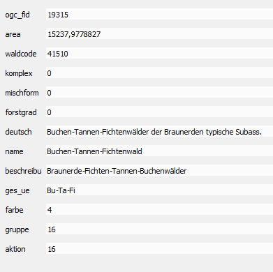
Baden-Wurttemburg : I took photos of several different examples of forest thematic maps in the small museum at the base of the Feldberg. The rest of the blog post is an account of walking through these woods.
Wales. National Resources Wales publish a Phase 1 habitat survey of the country and also target species data. The two can potentially be combined to provide dominant species cover. Many parts of England are also covered by Phase 1 (usually at the county level), but these are generally not available.
France. The national forest map is part of the IGN. I get email news from them, but dont know much more.
Italy. Some detailed data on forests with species has been imported into OSM for parts of Northern Italy.
Switzerland. Some geodata related to the National Forest Inventory is available on the geo.admin.ch portal.
I’d be interested in looking at the PL data for Zakopane as I failed to get good enough photos to establish were given species of trees are dominant. The forests here are very interesting because of patches of different trees in the same slope, and the odd presence of isolated beech trees even up to ~1500m.
Hope this helps.
PS. We don’t have well-established tagging for this type of thing in OSM, but I use dominant_taxon (so in your examples, this would be dominant_taxon=Pinus or dominant_taxon=Pinus sylvestris (which I think is the only common pine in Poland)