I am pleased to announce that I finally released v1.0 of my new plugin “Leaflet Maps Marker” - Pin, organize & show your favorite places through OpenStreetMap/WMTS, Google/KML, GeoJSON or Augmented-Reality browsers.
For a demo please visit http://www.mapsmarker.com/demo
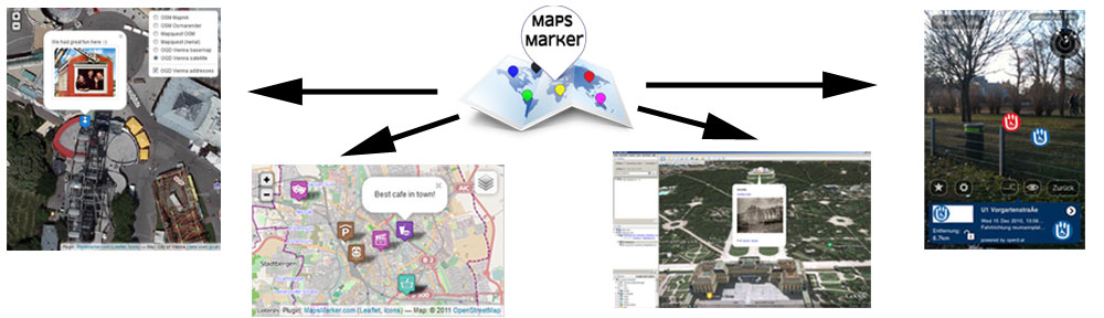
The Leaflet Maps Marker WordPress Plugin allows you to
-
pin your favorites places with markers,
-
use integrated address search (Google Places API) for quickly finding your places,
-
choose from up to 700 custom free map icons from Maps Icons Collection,
-
add popup description text or images for each marker,
-
choose individual basemap, size and zoom level for each marker/layer map,
-
organize your markers in layers and
-
show them thanks to the Leaflet library from Cloudmade
-
by adding a shortcode to posts or pages
-
through OSM/OpenStreetMap, MapQuest, OGD Vienna Maps
-
or any custom WMTS-map
to the visitors of your website.
Additional features
-
configure up to 10 WMS servers to display additional information from external geodata providers (like the European Environment Agency) on your maps
-
export your markers as KML file for displaying them in Google Earth or Google Maps
-
export your markers as GeoJSON file for embedding them in external websites or apps
-
export your markers as ARML for displaying them in the augmented-reality browser from Wikitude
-
export your markers as csv-file
-
option to set WordPress roles (administrator, editor, author, contributor) which are allowed to add/edit/delete markers and layers
-
option to add marker directly to posts or pages without saving them to your database
-
audit log for changes on markers & layers (saving first created by/on and last updated by/on info)
-
search within your marker list
-
option to reset plugin settings to defaults
-
option to change the default shortcode ‘[ mapsmarker…]’
-
dynamic preview of maps in backend (no need to reload)
-
WordPress Admin Bar integration to quickly access plugins features (can be disabled)
-
“OGD Vienna selector”: if a place within boundaries of Vienna/Austria is chosen, OGD Vienna basemaps are automatically selected
-
integrated donation links to show your support for this plugin

Technical details
-
WordPress Multisite compatibility
-
full UTF8-support for cyrillic, chinese or other alphabets on marker/layername and marker popup text
-
support for other languages through .po/.mo-files (please see http://mapsmarker.com/languages for details if you want to contribute a new translation)
-
GeoJSON feeds for every marker and layer with JSONP support
-
use of WordPress settings API for storing options
-
TinyMCE editor on backend for editing popuptext
-
version check for minimum WordPress (3.0) and PHP (5.2) requirements
-
use of prepared SQL statements to prevent SQL injections
-
use of WordPress nounces on forms to prevent attacks and input mistakes
-
use of custom function names and enque plugin scripts/css only on plugin pages to prevent conflicts with other plugins
-
update functions implemented for smooth updates of the plugin
-
uninstall function to completely remove the plugin and its data (also on WordPress Multisite installations)
Please let me know which feature you think is missing by adding your ideas at http://www.mapsmarker.com/ideas
Download latest version from WordPress-Plugin-Repository
I am looking forward to your feedback!