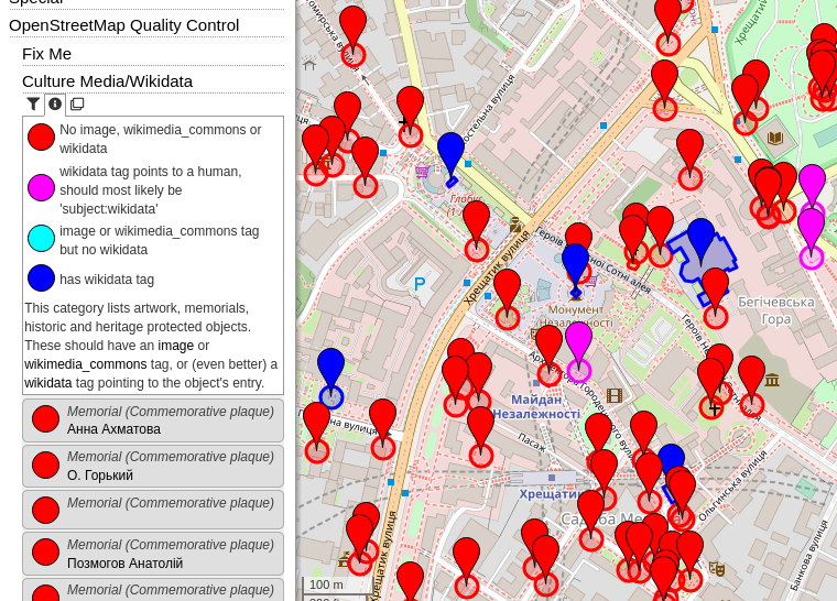
Recently I introduced a few “OpenStreetMap Quality Control” categories to OpenStreetBrowser:
Fix Me - All map features which have a “fixme” (or similar) tag, categorized by suffix (e.g. fixme:name) or content (e.g. “name wrong”). It can also filtered by type of feature (e.g. Shop, Road, …).
Culture - Media/Wikidata - In my opinion, each cultural map feature (artwork, memorial, tourist attraction, …) should have an image and/or a wikimedia_commons category (red=missing, light blue=set). Often, there even exists a Wikidata item (dark blue). Many memorials erroneously have the wikidata link to a person (magenta), this should most likely be a “subject:wikidata” (resp. “subject:wikipedia”) tag.
Wikipedia - This category was in the “Special” top category before. It shows all map features in the area with a wikipedia or wikidata tag (including prefixes, e.g. “subject:wikipedia” or “name:etymology:wikidata”).
I rather thought that presence of wikipedia tag should count like presence of wikidata tag (adding missing one if other is present already is job for bots/validators, not human editors)
BTW, amenity=place_of_worship should also ask for images
If I count it as wikidata tag, I also should check if it is a person (like for wikidata) - which is not possible right now (from the wikipedia tag value, I have to load the corresponding wikidata object via some SPARQL magic). For now, I will add an extra color for this. I could also, in a next step check if the wikipedia and the wikidata tag point to the same object.
How could I forget! I also added amenity=theatre .
I now also added the check for features with a wikidata object without image.
I use this layer on my smartphone while travelling to find elements without pictures. Is there a way to filter out elements that already have a picture? Also because often I get confused by the “wikidata+image blue” and the “has wikidata tag, but wikidata object does not have an image blue”.
Sure, no problem. I created a filter for the different categories (4f78539), I hope that helps.
Filtering for the items which need the result of the wikidata item will need some work in the internals of OpenStreetBrowser though (overpass-layer#25 and openstreetbrowser#168).
Uhm, not really in my case. If I filter “No image, wikimedia_commons or wikidata” I can’t see the elements with a missing image in the “has wikidata tag” (the light blue ones) and viceversa, so I would have to change filter all the time to have a complete picture of the situation.
For “cleaning up” a little bit the map it would be usefult tho to combine both the mentioned filters, so the “image or wikimedia_commons tag but no wikidata” filter would be cut off (or to just exclude this last one?).
I’m thinking more aboout a “checklist filter” rather than a “single choice filter” I guess.
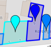
Definitely, what confuses me the most are (mainly the two on the right):
I added a “no image/wikimedia_commons OR wikidata without image” filter. I hope, this is sufficient.
About the colours: do you have a suggestion for a color scheme? You could create a custom category by cloning the category. On the bottom of the code you will find the colour assignments. If you have a scheme with which you are happy with, you can copy&paste the link to your custom category. More about custom categories in my short introduction video: Custom Categories | OpenStreetBrowser - YouTube (cloning categories at 1:24).
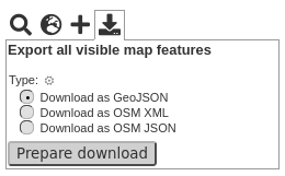
Yes, you can export all currently shown map features via the “Export” icon. There’s no assessment though, only the tags of the objects. You could filter the category before downloading.
I tried that already but I am probably doing something wrong, but I don’t know what. I downloaded the three files. If I try to import the .json or the .geojson I get this error “Unexpected token”, if I try to import the .xml file I get this error “I can’t read the GPX data”.
I see. Apparently OSMAnd can only read GPX files. The OSM XML is the .osm file format developed for OSM data interchange and is not GPX compatible. Sorry, apparently there’s no easy way to use the data for OSMAnd.