Hi,
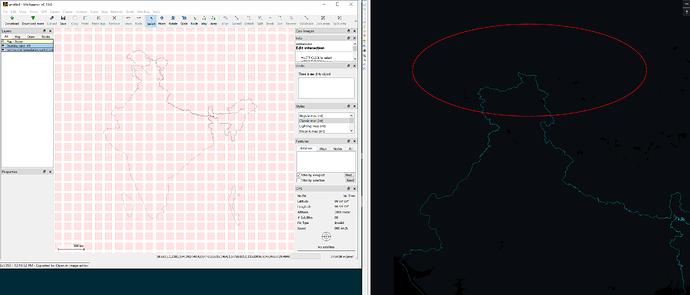
I’m working with OSM data for India. To get the proper admin boundaries for India, I have performed the following steps. The issue I’m having is that when I create vector tiles from the data, much of the data doesn’t seem to be included. While I’m dealing with just the boundary data below, my end goal is to somehow “augment” the boundaries from the original country-specific extract (or planel) with the official admin boundaries.
- Ran this Overpass query in Overpass Turbo and saved as india-admin-boundaries.osm:
[timeout:125];
(
  // query part for: “admin_level=2 and "ISO3166-1"=IN”
  relation["admin_level"="2"]["ISO3166-1"="IN"]({{bbox}});
  relation["claimed_by"="IN"]({{bbox}});
);

out body;
>;
out skel qt;
- Used osmium to sort the data to prepare for use with planetiler:
osmium sort -v -o /dataout/india-admin-boundaries-sorted.osm /dataout/india-admin-boundaries.osm
-
Viewed the resulting file india-admin-boundaries-sorted.osm in Merkaator and observed that the boundaries look as expected
-
Used osmium to convert india-admin-boundaries-sorted.osm to india-admin-boundaries-sorted.osm.pbf:
osmium cat -v -o /dataout/india-admin-boundaries-sorted.osm.pbf /dataout/india-admin-boundaries-sorted.osm
The resulting .osm.pbf file can be loaded with QGIS using the QuickOSM plugin successfully and it reflects what was seen in Merkaator.
- Used planetiler to create vector tiles in MBTiles format:
docker run --rm --name planetiler -e JAVA_TOOL_OPTIONS="-Xmx16g" -v /dataout:/data ghcr.io/onthegomap/planetiler:latest --osm-path=/dataout/india-admin-boundaries-sorted.osm.pbf --output=/dataout/india-admin-boundaries-sorted.osm.pbf.mbtiles --force
-
Planetiler completes with no visible issues and produces the MBTiles file.
-
Hosted the MBTiles file using tileserver-gl
-
Viewed the data via two means:
a. On the tileserver-gl “home page”, clicked the “Inspect” button next to the MBTiles file and viewed the data on the displayed map - some of the expected data is missing.
b. Pointed Maputnik to the hosted endpoint and viewed the data via both the Map (with my style) and Inspect views - same situation… some of the expected data is missing.
Screenshot showing Merkaator on left, Maputnik on right (red oval below shows the northern area where Merkaator shows more data):
I feel like I’m just missing some required piece of the process. Any help or suggestions would be greatly appreciated.
Thanks,
Jeff
