National Parks map

Hey guys,
I’m wondering, whether there is a OSM-map existing, highlighting the difference between National Parks, National Forrest, State Park,…
All maps I found so far do not differentiate between National Park, National Forrest,… like OSM Americana, which is already much better than OSMcarto.

I found a map of NPS in our wiki File:Map of the National Park System.jpeg - OpenStreetMap Wiki which looks like what I’m looking for, but the level of detail is not really suitable for any route planning.

Gaia Topo is OSM based, and shows these distinctions.

3 Likes

What sort of route planning were you thinking of doing?

Does Gaia actually get the information of the operator/type from OSM? I didn’t know that/if we had any tagging to differentiate these beyond protect class/nature_reserve.

I believe they just parse the name tag to see if it ends in "National Park”, “National Forest”, etc. They may also consider protection_title.

1 Like

Protected area categories aren’t really a universal thing. We don’t even have that strong of a consensus on how to tag stuff in the United States, with the best effort at this point being the United States Public Lands wiki page that I collaborated on with @stevea. It’s not even clear what counts as a “National Park” in this context. Any area administered by the National Park Service? National Forests? National Battlefields? Etc.

That said, because categorizing these areas tends to be national or local in nature, and inconsistent at best across nations, we’ve thus far taken the approach of rendering them the same.

Long post ahead, fair warning.

Thanks for the mention, Brian @ZeLonewolf, though it has been many more than simply you and I who have endeavored to develop and improve the Public Lands wiki over the years. This topic is something I have striven to better express in OSM (both in the map and in that and other wikis) for nearly the entire 14+ years I’ve been a Contributor to Our Fine Project (OFP=OSM!)

Speaking colloquially about the USA here and now, that Public Lands wiki goes a certain distance to explaining that there is a highly complex fabric of “public lands” in many thousands of jurisdictions (federal, state, county, municipal / local, even private homeowners associations where the land might be “permissive” by the owners, sort of “quasi-public,” but is actually private). It is deeply complex because of the various agencies even within the federal government alone, maybe if you add in state governments (as evidenced by the “Public Land” legend of Gaia Topo referenced by @ezekielf; thanks Zeke): in any given “area,” one might find “public lands” administered by no fewer than four jurisdictions and from many multiple agencies — maybe even several of them all federal!

All that said, to answer OP’s original question, I believe that OSM does presently have a “rough framework” in our data of the distinctions (at least at the federal level) of National Park, National Forest, and so on and at the state level. This gets better state-by-state, but this is slow going. OSM will need to better articulate (in that Public Lands wiki) how we do (descriptive) and should (prescriptive) tag these entities (at a state level, especially). THEN, renderers (if they choose to do so) can display these, but we continue to contend with age-old issue of “getting the correct, agreed-upon data taggings into the map itself, FIRST.” We must describe what these ARE (DEscriptive tagging at the federal level, that wiki does an OK job of it, but state-by-state we need much more effort) and we should (imo) describe what these SHOULD be (prescriptive tagging) on an ongoing basis. We only have a handful of states in that wiki now, but long journeys begin with the first steps.

As we do come closer to completion of both federal de-/pre- -scriptive tagging in both all 50 states and at the federal level, downstream, end-use cases (like routers as the OP asks, overlays, OT queries, renderers — yes, Americana keeps doing a better and better job of rendering AND displaying a “live legend” of these)…it will get better and better. But we do have a fair bit of work to do: the concept of boundary=protected_area as a (sort of “naked” tag) was something Brian and I worked on as a semantic exercise over the course of many months. It was like a puzzle we had to unravel, and it turned into a joint proposal by both of us, Proposal:Park boundary - OpenStreetMap Wiki . What this does is strip down ANY “protected area” to its essential core (what we “figured out” semantically makes sense) as a boundary=protected_area tag, then “builds it back up” as a more-complete (and in the case of some “parks” or whatever it might be), and in some cases “more complex” park "entity.

For example, it could be that the “front country” of the “park” has commonly-used amenities like viewscapes / wildlife observation, shorter, easier “nature hikes,” restrooms and/or concessions, easy parking, a visitor center, et cetera. The “back country” of the “park” might have little more than wilderness trails, primitive campgrounds and virtually no other services, but caters to intrepid backpackers (or maybe mountain bikers), for example, those who know how to carry their own water/food, clean socks and a tent and sleeping bag.

How OSM displays / renders these, or allows routing on these (obviously) requires good tagging, but that in turn requires agreement among (again, I’m USA-specific here…maybe in your country you do something similar) OSM’s contributors that we “tag correctly.” I believe we are on our way to doing so. This is evidenced in better-tagged areas “nicely” displaying in Americana and Gaia Topo (correctly tagged) as they do. But we have much more work to do, especially at the state-by-state level (as seen in the rather sparse table of the Public Lands wiki).

In short (too late), “this gets better,” but it depends on a really strong foundation of agreement / consensus on how we should tag Public Lands. We’re in earlier-to-middle stages of this (imo), but we need to keep building both our consensus and our map’s data. THEN, we can “route” (or render…) more and more accurate Public Lands. I realize much of this seems obvious, but it doesn’t hurt to take a snapshot of how our “slow moving database” continues to grow, and become more and more correct, though rather slowly. We’re getting there. Good dialog really does help.

(I’m largely leaving out how the widely-encompassing word/concept of “park” in US English rather badly conflicts with the OSM-specific quite narrow definition of leisure=park. OSM had contentious semantic unraveling of that in 2018-19, and I think we got it largely understood and documented in our various wikis).

Thank you for reading.
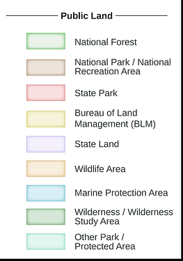
2 Likes

Gaia GPS seems pretty much to be what I was looking for, but seems only to be available for Premium Users. Thanks for pointing me to that service.

@Kai_Johnson I was kind of checking areas for some biking trips so mainly doing some distance calculations and checking the area in between in terms of whether it’s interesting to bike there.

I’m currently playing a bit with overpass turbo and at least for National Parks it’s seems to be pretty good. Mount Rainer and Smokey Mountains seems to be missing the protection_title=National Park

1 Like

Yes, Henning: because of the way that Gaia appears to pay close attention to the protection_title=* key, this is a crucial tag to set for any national park: feel free to add (or “sharpen focus” on) any such key to a “park” which may be missing this well-defined tag. (For example on Mount Rainier and Smokey Mountains). And then, Gaia will render (on its own schedule, of course) with better, more accurate renderings. And up and up our map grows!

1 Like

Thanks for your pretty detailed description, really appreciate. I’m pretty new to the US and it help to understand the issue a bit. From my international traveling so far I can tell that I haven’t met a diversity in such a kind the US is having on “public land”. Which might be relate also, that most maps do not differentiate about such differences.

1 Like

Again, while I think OSM (in the USA) is in earlier-to-middle stages of better developing / improving our “parks” (and that’s a huge set, MUCH more than simply leisure=park as an “urban human-sculpted greenspace”), it certainly does get better and better. Especially as Gaia pay attention to our wiki and hence parses our protection_title=* tagging.

As you mention, the USA might have complex methods to describe such Public Lands, but I believe that both OSM as a database (with good tagging as a necessity, good tagging is often communicated with clear wiki) and OSM as now having renderers (and routers, further end-use cases for specific map data consumers like cyclists, campers, hikers, equestrians…) makes OSM one of the best map “systems” out there for communicating the real complexities of the USA’s multitude of Public Lands. It really is complex, yet we (as a group of people who must communicate and agree with one another) do a fairly good (and growing) good job of it. It is a real strength of OSM that it is “plastic” enough, with the robust strength afforded by good agreement among its Contributors, that we are able to do this: as you say, “most maps do not differentiate,” but OSM (rather proudly, because we CAN!) actually does!

Check out GPX Studio. It runs on OSM data and has great routing options for cyclists.

You do get more features with premium, but they offer all the basic functionality for free these days. Premium mostly gets you a whole bunch more map layers (free just has a few), and the ability to download areas for offline use on the phone app.

Maybe my post was misleading. I was not really looking for a planning tool ( usually I use brouter-web ) but mainly a map which differentiate the public lands (and that layer is premium only). But so far I learned in this discussion and during playing with overpass-turbo… the issue seems to be mainly in our data. For National Parks it’s kind of good, but it seems to get already starting to become a nightmare for National Forrest…

So this is how far I got: overpass turbo (200 mb querry)

1 Like

The default layer (Gaia Topo) does this and is available for free. The legend I posted is from that layer.

Indeed, I must have been blind on my first visit. :crazy_face: