In the countryside we do have junctions similar to small mini-roundabouts, often three-road-triangular junction areas where there is no through direction so to go on cars will aways make a slight turn, but most are either turned into true roundabouts (with at least signpoles in the centre island, and too large vehicles are banned from the approaching roads), or just the visual warning circle / raised central dot / no centre at all.
Thinking the other way around: if the centre must be kept free for oversized vehicles, the junction cannot be a roundabout. Either make more room, or forget the roundabout, junction constructor people!
For priority it does not legally matter if it’s a roundabout or not. Priority in NL always has to be signed separately by traffic signs and shark’s teeth markings. The roundabout sign legally means: oneway circular movement, nothing else. All other things need to be signed or marked. As in other countries, many other rules of conduct are flying all around the place, but they are not laws, and only enforcable under the general rule of “not endangering anybody”.
I understand that in the Netherlands the round blue sign “roundabout” is on the central island and therefore there can be no mini-roundabouts with a sign “roundabout”.
But: the sign “roundabout” is not a prerequisite for a roundabout to be a roundabout, seen worldwide. The British, for example, only use this round blue sign for mini-roundabouts.
OSM distinguishes:
Circular traffic routing without right of way in the circle: junction=circular
Roundabouts with right of way in a circle: junction=roundabout (how the right of way is regulated and signposted is secondary).
Both of the above have a central island that cannot be crossed.
Mini roundabouts have right of way in a circle and a centre island that can be driven over.
And then there are many intersections that look like roundabouts but are not roundabouts, not even mini-roundabouts. These are traffic calming measures or turning loops or sometimes simply a decorative design.
I once used overpass-turbo to search for mini roundabouts in the Netherlands. As expected, most of them are not mini-roundabouts. There are trees in the middle (not passable); there are circles painted on them, but no shark’s teeth or right of way signs; and one or two just look pretty …
You could clean all that up, they’re not mini-circles!
Of course, I can’t look at all of them. But I have found one (unfortunately without a mapillary) which, according to the aerial photo, is very probably a mini roundabout and very close to the British original, except that this one goes anti-clockwise.
But the approaches have shark’s teeth, the crossable centre is made of white circles and the direction of travel is marked with arrows on the ground and the diameter is only about 14-15m: Node: 47131877 | OpenStreetMap
And to the northwest is another mini roundabout.
And yes, you can see from the aerial photo that drivers do not obey the rule of driving in circles, even though they could. But that doesn’t matter, cyclists also sometimes ride on the footpath even though they are not allowed to, yet the footpath does not become a cycle path
And it should be possible to map such traversable mini-circle junctions, which are sometimes not so mini anymore, both as a point with highway=mini_roundabout and as a way. How we tag the latter without losing the drive-over centre island in the data is the subject of discussion.
edit:
This is also a mini roundabout:
No painted, but slightly raised central island, can be driven over.
No round blue sign “Roundabout”, but traffic on the circular lane always has right of way.
The fact that you have to drive anti-clockwise probably only results from the right-hand driving requirement. OpenStreetMap
First off the UK Highway Code is simplified guidance that can be used in court, and is often based on actual laws and guidance found in more authoritative documents. (eg The Traffic Signs Regulations and General Directions 2016) or publications such as “Mini roundabouts: good practice guidance”.
To engage specifically with the guidance for signalling. It best to state that a standard roundabout has different signalling requirements, but a mini-roundabout doesn’t. As well as standard entry signaling, you always signal left when leaving a standard roundabout (drive on left). Due to the small size of mini-roundabouts you don’t signal left when leaving the mini-roundabout (unless it’s the first exit). Hard to describe in writing, but if you look at the image with Rule 185, or the gif below.
Nicely found! Yes, it resembles a mini-roundabout. And tagging it as such conveys the priority rule. Which on the way is only conveyed by the shark’s teeth. Otherwise you would have to add a full three give_way nodes. So, I don’t think it’s necesaary, but I do think it’s correct!
It’s near endearing how they have tried to create a circular lane on the inside of the cycle lane, leaving a circular ‘lane’ where not even IJsbrand Chardon could manage to stay in lane. I bet 90% of the cyclists would cross over the center dot, which is hardly visible any more!
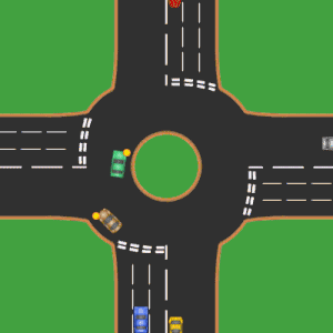
In contrast, this one connects four ways, it has a raised centre island, the circular lane is manageabe for most cars and vans, but the centre will be crossed over by buses and trucks, so the centre circle can not contain poles and signs.
Still, this is a roundabout, because all roads have paint-separated approach and exit lanes, and the approaches (which curve toward the circular lane) all have the roundabout sign, combined with the give_way sign. So it should be mapped as a regular small roundabout.
Could you point to the law that says there are any requirements to indicate at all? It is my understanding that there is no law on the statute books that says one must indicate, under any specific circumstance.
I believe (and may well be wrong) the “requirements” you mention are actually all guidance as laid out in the highway code.
Of course, as has been discussed in this thread, although the rules in the highway code are not directly enforceable (unless they use a MUST/MUST NOT as these are covered by law) they can be used as contributing factors for prosecution under other laws (e.g., driving without due care and attention/dangerous driving).
Having said all of that… it doesn’t really matter!
The legalities are for the driver not the mapper. We should just make sure it’s tagged correctly (e.g., the proposed junction=mini-roundabout).
The UK Highway code has a large number of “should” or guidance, that are not directly mentioned in law/legislation. This results in a huge number of people incorrectly believing they are not enforceable. If the “should” or guidance involves Driving activities, they ARE enforceable.
Could you point to the law that says there are any requirements to indicate at all? It is my understanding that there is no law on the statute books that says one must indicate, under any specific circumstance.
The Road Traffic Act 1988, contains the offences of “Dangerous Driving” and “Careless, and inconsiderate, driving”.
When deciding what actions amount to the above, the “should” or guidance information are considered the default, or primary, examples of what constitutes these offences.
For not signalling you should be charged with “Careless, and inconsiderate, driving” under the Road Traffic Act 1988. But you could be charged with “Dangerous Driving” if there was clear evidence of likely harm from the action.
It’s notable and worrying that so many UK road users believe the “shoulds” in the Highway Code are not enforceable. They’re simply wrong about this. The UK Highway Code also has a list of Do Not, which are also considered the default examples of actions that are charged for offences such as Dangerous Parking.
Coincidentally I am about to submit a video to the police of a driver ignoring one of the “shoulds” in the Highway Code. Rule 163 states a driver should leave 1.5m of space when overtaking a bicycle. I was passed by a van that left 0.5m and have a video of it. I will shortly submit the video to the police who will almost certainly charge the driver with “Careless, and inconsiderate, driving” due to ignoring the “should” in Rule 163.
Thanks JassKurn, hiding most of my reply to your (interesting!) response in details to keep the thread tidy.
UK legalities
Hiding this, as we’re veering (pun intended) off topic here.
Is this a legally held opinion or your own? (Sorry, no idea what your background is.) Other sources disagree with you [e.g. 1]:
Breach of the Highway Code is often a good indicator of carelessness, but it doesn’t establish guilt in itself.
It seems more like “could” for both offences. Lack of use of indicators is not, for example, one of the listed contraventions listed by the police for either offence. Although that list isn’t exhaustive of course!
I do agree, keeping the mini-roundabout information is important, but I don’t think that prevents us from mapping as way in the UK - unless there’s something I’ve missed?
Interestingly, only ~27% of highway=mini-roundabout tags are located in the UK. However, you’re right, this probably does represent a plurality of usage by country.
Done some checking in NL. There are a grand total of 79 highway=mini_roundabout nodes. I didn’t check them all, just random quick peeks e.g.:
A true (signed) roundabout, raised and kerbed middle island (think truck apron without the undrivable centre island) just small so the mapper didn’t bother to map it with a circle, then cut it up and adapt the routes. Understandably: The junction node is also a Numbered Node in both a Walking Node Network and a Cycle Node Network, and a bus route passes the junction, so that’s some tricky work, especially the bicycle routes and the bus routes.
A dot-junction without the roundabout sign, just a dot and a hint of a circle, and priority for whoever is first on the junction. The movement on the junction can’t be called oneway or circular, because even one car will occupy the junction including the middle dot!
A junction with a centre island with a pole in the middle, and roundabout signs at some of the entries, but without any give_way signs.
Case 1 I think meets the functional criteria for a mini-roundabout
Case 2 Calling this a mini-roundabout is totally useless. But it doesn’t harm either. However if a renderer decides to display mini-roundabouts as a circular way, I think this one would not match reality.
Case 3 Is not a junction=roundabout nor a highway=mini_roundabout, despite the sign, because there is no priority for traffic on the circle.
So, should we decide to act, I guess still a few mini-roundabouts will remain. Which is more than I would have imagined a week ago!
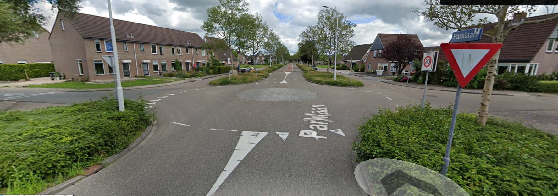
I think this one has been deliberately designed to mimick a roundabout, but it’s just a regular crossing of two single carriageway roads. If a car goes straight on, it will not move an inch to avoid the centre dot. If two cars are approaching head-on, both wanting to turn left (remember, it’s right hand side traffic) they surely will not (and need not) go around each other. I will remove the highway=miniroundabout tag from this one.
That not disagreeing with me. It’s simply a statement of the obvious. Guilt will be established by admitting the charge, or by a court. I do have some experience with Highways Legislation, and I know drivers are charged because of not indicating but usually where it involves a collision.
It seems more like “could” for both offences. Lack of use of indicators is not, for example, one of the listed contraventions listed by the police for either offence. Although that list isn’t exhaustive of course!
“could” applies to all offences. Your link includes some of the offences that have been charged under Dangerous Driving & Careless/inconsiderate driving charges. As I said before, the starting point is the guidance found in the Highway Code, which advises you to indicate and when to indicate.
We map separate ways in cases of physical separation. We don’t map separate ways where there’s just paint. The “space” between ways is used in OSM to imply physical separation.
So if there’s a four-lane road with just paint down the middle, we map it as a single way. If there’s a road with a painted-lane cycleway down the side, we map it as a single way.
But if there’s a genuine dual carriageway with physical separation, we map it as two ways. If there’s a cycleway separated from the road with a concrete barrier or a grass verge, we map it as two ways.
The same should apply to roundabouts. Mapping a mini-roundabout as a circular way would be wrong. The “space” in the circle implies physical separation. That physical separation isn’t there. It’s simply paint.
So we should continue to map UK mini-roundabouts as nodes, just as we’ve done for 15+ years.
The reason for this discussion is the wiki definition, that everything that has a traversable center is a mini-roundabout and should be mapped as a node. Which may be true in GB, but not elsewhere. I have a roundabout with such a traversable island near my house. Hence the idea of loosening the definition (i.e. not everything with traversable center is a mini-roundabout) OR letting mapping mini-roundabouts as circles.
Personally, I’d prefer the first solution i.e. if something is traversable, but big enough, it is a regular roundabout with maybe some tag saying that it has a traversable center. I like the idea of central_island:traversable .
This version is in between, around 2020 to 2021. OSMCha
It is correct with mini-roundabouts. But not entirely correct - the connection from Morlaix Ave to Arch Hill past the mini-roundabout does not exist in reality.
Still, the geometry looks wrong too - nobody drives like that.
The current version is of course lane mapping and just as wrong. But the geometry would be better and more detailed with circular ways. Especially if at least one of the leading roads has separate carriage ways.
To be clear, no one wants the typical British small mini-roundabouts to all be changed. But I think there is a desire and apparently a need to map larger mini-roundabouts (up to 28 m diameter in the United Kingdom!) or more complex mini-roundabouts (e.g. with separate entrances and exits) better, in more detail, more realistically in the data. This would also avoid such constructions or depict them more realistically: OpenStreetMap
Last but not least: the world out there is changing, OSM is changing and has to adapt to the reality out there. Simply saying we’ve always done it this way for 15 years can block further development of the project.
You Brits, rejoice, you invented the mini-roundabout (thanks to Mr Blackmore!) The mini-roundabout has made its triumphant march around the world and has long ceased to be a purely British product. The rules are often only minimally different, but the basic principle is always the same. And the British are also moving with the times and have adapted their building regulations for new mini-roundabouts to today’s requirements - British mini-roundabouts can, for example, become larger …
What is missing is the last step: a contemporary adaptation of the OSM rules for mini-roundabouts.
I agree with this where all roads involved are single carriageways but I’m not so sure with dual carriageways. One of the concerns raised further up is with cases where a dual carriageway crosses a single carriageway and there is a mini-roundabout at the intersection:
(satellite view available in original post).
In these cases I think there is a valid question as to whether mapping them as a circle is closer to the experience of using them than mapping them as a node as in practice you are not normally turning left into the mini-roundabout and then executing a 90° right when you intend to continue along the dual carriageway. If the roundabout was missing there would normally be an intersection per carriageway but that wouldn’t leave a common node for the highway=mini-roundabout.
I wonder where to put these in this current, poorly aligned bowtie along Via De Cecco. While not physically obstructive many are actually laid out in paving stone rather than painted, just flush with the road, the center often a slight hump. coloured paving stones don’t need repainting every year or two.
In Nederland, they often are like truck aprons without the intraversable part in the middle. I map truck aprons around a centre island as barrier=kerb, they are part of the separation. If it’s only paint, flush with the rest of the junction area, it’s not a separation.
OTOH, I also have seen roundabouts with a sizeable centre island which is just paint (a lot of it). I would not map such junctions as nodes.
So I wouldn’t carry the “physical separation” thing too far.
E.g. dual carriageway roads may have stretches where the separation is physically traversable, but we don’t join and split the ways all the time. I think a painted mini-roundabout in a dual carriageway road is in that same category. I would not join the separate ways just for the junction.
So, Winston likes to know, when we tag ‘full’ roundabout on / off ways with the qualifying tag oneway_type=roundabout_flare, then when the ‘not full’ roundabouts are mapped as node [against common sense] but some or all on/off are split by real flare area:highway=traffic_island, do we tag those on / off as oneway_type=mini_roundabout_flare ;?
Rest assured, my mission is to map ground truth reality, WYSIWYG.
I finished checking all highway=mini_roundabout nodes in Nederland. This is the overpass query I used:
/*
Find all highway=mini_roundabout nodes in Nederland
*/
[out:xml][timeout:250];{{geocodeArea:Netherlands}}->.searchArea;
node
[“highway”=“mini_roundabout”]
(area.searchArea);
(._;>;);
out meta;
Found mostly only-a-dot junctions, just removed the tag.
Some were rotaries: they had the traffic sign, but lacked the priority on approaches.
A few were not mini_roundabouts but true roundabouts: the center circle had e.g. a concrete block or a signpost on it.
Only 9 are left, which I thought deserved to be called a mini_roundabout: most have the roundabout traffic sign, the traversable center and the required priority signs. Some lacked the roundabout sign but had paint-separated approach/exit lanes and clear arrows on the pavement indicating circular traffic; I thought highway=mini_roundabout was closest to the ground truth.
today discovering a 4 month old map note and a ground pic of june 2023 (ex street view). The grass traffic island below the pin turned road surface e voilà
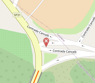
A low budget roundabout. It’s an SP (Strada Provinciale), were it an SS road (Strada Statale) ANAS would churn out a fully fledged signed and all in a couple of weeks ( (with big ANAS poster painted on the central raised island). Good day tomorrow to cycle there and ‘survey’ how it’s really today. Till then, no mapping.