Question re “milestones” i.e. plates on a post at the side of the road to say “G 50” e.g. https://goo.gl/maps/oQBAVNkH68DwaYPp8 (& as always G is only used for illustration purposes blah, blah, blah). Tag:highway=milestone - OpenStreetMap Wiki seems to say that they’re supposed to show the distance from wherever, not the distance to? So are they milestones, or something different? If they are, what do we want to put on them? distance=G 50? (In this case, that’s Gayndah)
The ‘milestones’ on post, large black number on white background above smaller white/blue with the route number here are giving the distance from the start of a named route like SP63 in one direction and coming from the other way, since most are double sided, the distance to the start of that route. Never paid attention but think the placement side of the road tells it’s N remaining or N since. Every 100 meters there’s a number with a roman above, quick to see if it counts down or up.
On the motorway they are mostly placed on the direction separating guard rail / jersey barriers, again mostly double sided
Set up a little custom preset with all there’s to know.
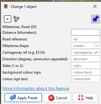
Makes mapping life easier with less to remember.
distance=* is currently defined as just a quantity with optional units. This is problematic in regions that signpost reference locations as an offset from another milestone or as a postmile equation, but I think it would be better to introduce a subkey for those idiosyncratic formats than to overload distance=* with them.
To indicate the frame of reference for the milestone, you could consider to=Gayndah. A sign in the other direction could be tagged from=Gayndah. destination=Gayndah would be the more obvious tag in this case; however, for a sign in the other direction, origin=Gayndah could be problematic, because origin=* is currently used for a completely different purpose.
So highway=milepost + distance=50 + to=Gayndah?
They aren’t set up as pairs on each side of the road, one facing this way & the other the opposite way. In the opposite direction, somewhere with a few km of this one, there would be another to say BBS 20, which is 20km to Ban Ban Spring.
If the signs never state a distance from a place, then destination=* would be more compatible, because from=* and to=* are normally only used on route relations. This page seems to indicate that some signs indicate a distance from a place, but they could be obsolete signs for all I know.
Added: Australian Tagging Guidelines/Roads - OpenStreetMap Wiki As always, all comments welcome!
Heh, maybe a distance from a place could still use destination=* but with a negative distance=*. ![]()
distance:forward= / distance:backward= based on teh direction of the road, or even combine them with negative - distance:forward=-50, distance:backward=25 ? ![]()
![]()