Hi,
gibt’s irgendwo ne gute Dokumentation zu dem Thema? Mir sind die Zusammenhänge noch nicht ganz klar… 
Eine Dokumentation wie das Plugin zu verwenden ist? Oder eine Dokumentation von dem Code des Plugins?
Ersteres hast du bereits selbst verlinkt.
Letzteres findest du hier: Kaart / JOSM_MapWithAI · GitLab
Die AI-Daten sind die gleichen wie in diesem Projekt hier: GitHub - facebook/RapiD: An editor for OpenStreetMap for mapping with AI-generated features.
Der RapiD Editor (Frontend) ist hier verfügbar: RapiD
Die Hauptseite ist hier: https://mapwith.ai/
Fehlt dir noch eine Information?
Den Zusammenhang mit MS footprints verstehe ich nicht.
Plugin author here:
I’m going to answer the question “Why does the plugin also download Microsoft buildings?” I’m going to hope that is what you were trying to ask.
Microsoft has made their buildings available for use in OpenStreetMap. The same endpoint that provides the AI detected roads from Meta/Facebook also provides buildings from Microsoft (using a query parameter). That endpoint also does the conflation for Esri-provided building datasets.
If you don’t want to get the buildings, you can disable that functionality by going to JOSM Preferences → MapWithAI preferences → Select the default MapWithAI entry in the Selected entries: list → edit button → Uncheck the buildings parameter in the Set parameters list.
@mcliquid : Heads up, I’ve moved development to GitHub - JOSM/MapWithAI .
Note: I’ve read this conversation through machine translation. I may have misunderstood something when I tried to figure out what was meant to be said/could have been said.
4 Likes
Ok, thanks.
BTW: There is an error message when starting JOSM:
SCHWERWIEGEND: Fehler beim Laden des Bildes 'MapWithAI'
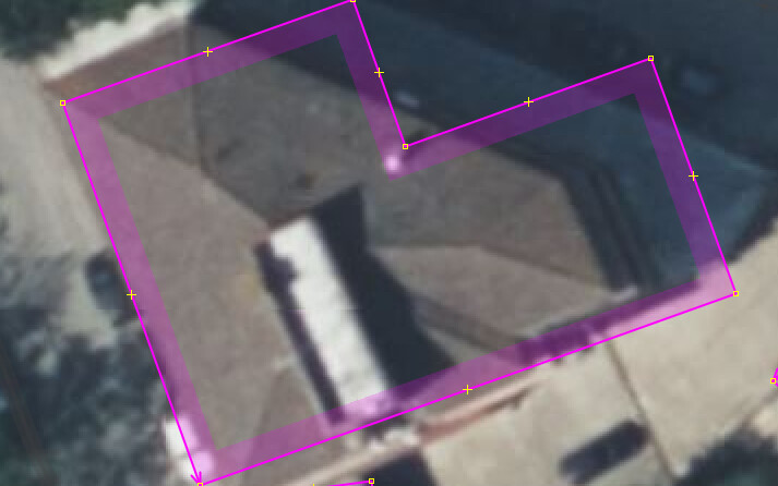
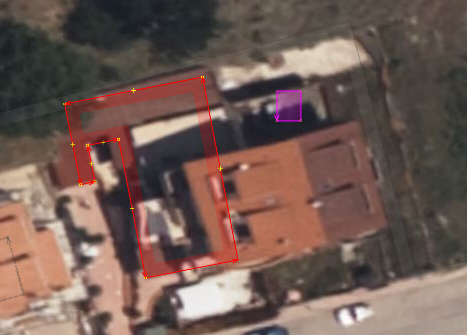
Just discovered this tool via a vandal report who used Rapid which mentions MapWithAI. Installed plugin, fetched data and now have a screen with pink building outlines which matches Bing sat imagery positioning with buildings that have not been mapped yet. When taking OSM Carto as background it confirms. Tempting but needing lots of work as the already mapped building have not all the same position as Bing has them (mapped with whatever else sat imagery of whatever year with different offsets). There’s fringe overlays, building that fall partially outside mapped residential areas and it’s of course bare bone, just the outline. Maybe grab small group, typically the countless farmyards that have no mapped real estate. No concerns of fitting with previous mapped assets in perfect alignment along main street. Verify correct position and in they are… something like that, each building needing checking the shape as this example demonstrates AI and MS have troubles, all is perfect 90 degrees at wall corners.
What this is, don’t know, AI maybe responding the reflection in the basin water
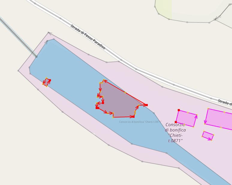
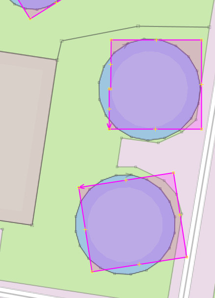
And then these waste water clarifiers, perfectly round in real life
TBC
Yeah, there are some interesting false positives. Sometimes they can be expected such as parked RVs or containers being misclassified as houses. But sometimes it’s quite surprising which patterns can trigger the detection.
1 Like
The whole manual printed in the JOSM status bar.
18 heavily modded buildings pulled in small steps, orientation, roof types, shapes, many are oversized due shade on free standers. Not sure this speeds up mapping them at all, but if the motif of the data providers is to just get building=yes pancakes on the map, it could work as an addictive driver. There was one who reached 69,000 buildings mapped on 60 day rolling stats of the Neis country billboard, like 1200 a day.
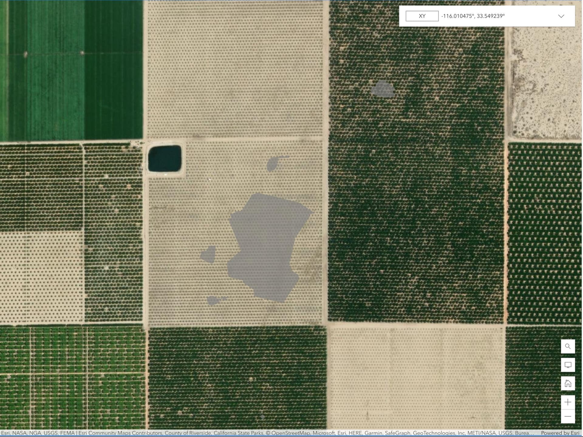
There are thousands of errors everywhere, the one I see the most in my region is to confuse light-colored trees that stand out from the green background of the plant mass with buildings. another quite peculiar is to suggest polygons of buildings in the middle of the course of a river. They are simply suggestions, the real problem begins when the mapper intervenes and does not verify what is being suggested and just clicks adding everything that appears on the screen. Bing Maps has added Microsoft Building Footprints to their map styles without as much verification as possible and this has rubbed off on hundreds of OSM contributors doing the same. The result is non-existent buildings in the middle of forests and in the middle of rivers.
Example 2 Follow the course of the river in any direction.
The examples above are a small sample of what currently exists, and although some non-existent buildings have been moved to OSM, these data are easy to simply correct just erasing.
What is really worrying is that it tries to normalize and standardize mediocrity, talks, surveys and exhibitions advocating for a Greater Quantity of Data = Less Quality is better than Less Data = More Quality.
Been using the tool and concluded that AI needs assistance
- From the Italian perspective having the below option default disabled would be good. Know of a few other countries where addresses are (almost) always on nodes. Apartment buildings with 150 housenumber nodes look pretty interesting in that.
![]()
At any rate seeing the addresses disappear and to house numbers showing up on the building centre made for a surprise.
-
Selecting buildings in the MapWithAI layer. There’s JOSM Lasso which selects all nodes that are in the drawn ring area but am looking for a function like drawing a box which selects the objects rather than the nodes. Maybe something with MapWithAI layer specificity. If closed way, a line or a single node.
-
Pulling buildings in small areas from MS footprint database and editing/orienting/positioning, roof details etc. It would be good if the next pull considers buildings not yet merged into the data layer with Shft+A. Fetching building from an adjacent area is not exact and you end up with the edited building plus the original MWA buildings on top. The plugin is aware which buildings are in the data layer, it would be good it’s also made aware of those in it’s own layer.
-
Colour buildings that have been fetched but edited different in the MapWithAI layer. This tells which ones were AI human assisted. In a larger area, like the last session pulling in 30 makes for easy keeping track which are OK, what still needs work before Shft+A. The pinkish purple style seems derived from the source value ‘microsoft/’, so maybe microsoft2/.
Thanks for considering.
1 Like
- I (personally) like that option enabled, but I understood that some people would not like it. That is why it is toggleable. If it is adding addresses to the building outline when you are adding multiple addresses in the building outline or an address already exists inside the building outline, you found a bug. Please file a bug report with an area where I can reproduce. It is supposed to only add the address to the outline when it is the only address for that outline (on the OSM data layer).
- This would be an interesting feature to work on. IIRC, I did some code whereby ways/relations would be preferentially selected in the MapWithAI layer, but I don’t think that is what you are looking for.
- This is a really tough problem to solve in JOSM. Part of the problem is that JOSM rewrites ids, which makes it difficult to map duplicate buildings when the user has been fiddling with the data. There is some code in there to try and reduce/remove duplicates, but it really depends upon the location of the nodes.
- I hardcoded the colour for
microsoftandmaxarto be the magenta colour. Other colours are randomly selected from a palette of “known good” colours. The hard part about tracking pure AI verus AI + human edits is that the original base state isn’t truly stored. I can kind of get it by using the undo/redo commands, but that will slow down the map render process.
Considering that a building outline is in the essence a (closed) way to JOSM as are roads, I’d say please go for it. Advancing to that, for Lasso to work I have to hold the right mouse button. Maybe a combo of holding the keyboard control key to kick it into way select mode while circling the area of choice.
- only experienced this moving of address to building outline when an address was mapped at the place where the house door was i.e. part of the building nodes. Not seen for multiple addresses on the outline. To test I put 2 address nodes on the outline and Shft+A without selecting the address nodes, only the building. It got merged including the addresses into the data layer with the address nodes in tack. Returning to the MapWithAI layer the address nodes were left intact there. Repeated this, specifically selecting building plus address nodes as well, did Shft+A and the addresses got copied over but not removed from the MapWithAI layer. The one specific country unlikely to ever use this plugin for building imports is the Netherlands. They have the everlasting BAG thread in their community forum. Ask for a building including (re)constructions to be imported and someone does this post haste. Think it does addresses too, not sure.
Anyway, now that I know of the toggle it’s off.
-
Bing/MS has a bìg and inconsistent offset so there’s practically no building that remains in the same place after import, that makes this duplication kind of unavoidable it seems.
-
I’ve modded my simple 3D custom preset to show the MapWithAI tags as well. I’ll edit the source by hand to know which are complete in the MapWithAI layer.
thanks for reading.
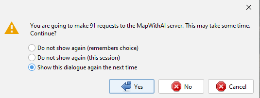
I’m sure I read a comment by @vorpalblade-kaart somewhere about the toggle on the data download screen to switch fetching for MapWithAI fetching on and off, so I set it off if not wanting any. Regrettably long as there is the MayWithAI layer, my JOSM continues wanting to download buildings/way, sometimes giving a warning about like the plugin is prepping to fetch so much in so many requests. Looked in the JOSM MapWithAI github but there’s no bug report option on the menu. Anyone else seeing this?
Picture of message notwithstanding the toggled off MapWithAI download box
From the Github repo (in the README#contributing section):
- Issues are managed in JOSM Trac
- Report a New Ticket
I’ll check and see if I can repro that bug though.
1 Like
This in fact already works to me unexpectedly. Today simply drew a select box across a group of buildings made ready for merge including other bits added such as roof solar panels. All nodes got selected alright and hit Shift A. Everything selected got merged to the data layer, object nodes, the works nothing untoward such as only the nodes.
What keeps showing as a pop up is this
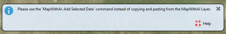
The MapWithAI menu says that Shift+A is the quick shortcut and everything works as expected except this message giving the show after the active layer switched automatically from the building layer to the data layer where the selected building were auto-moved
minor quibble.
This was due to a feature I made to work with the continuousDownload plugin (that could be toggled via right-click on the MapWithAI layer). I’ve released a fix which synchronizes the state of that option and the option in the download window. Let me know if it works for you.
I haven’t made any changes w.r.t. the selection and addition code in quite some time. But I think that was one of the primary considerations when I was making the anti-import code; if a user selects a node of a way, import the way instead of just the node.
I’ve never seen this, and I was unable to reproduce. Can you please file a ticket? I will need the status report at a minimum (just to sanity check the version of the MapWithAI plugin).
1 Like
For my understanding, with OpenWebStart run to keep JOSM always fresh on the stable /tested version, this 'released a fix" was actually pulled into the production environ? I’ve noticed OWS Pulling a few new files today during startup.
Update: Restarted JOSM thru OWS, saw it again pulling few files, loaded a big data set and went to village I’d been working on. Pulled in few buildings, edited, Using the select box to grab all checked buildings and did Shft+A. Moved over to data set. No popup to say I have to use the menu.
Fetched more buildings, worked them, did the ABC again and no popup. Toggled MWA off in download window and chose larger area and hoovered. No buildings fetched, no warnings I’d be fetching N buildings. Repeat and same, no warnings at all.
Seems you did a 2 for 1, but will raise a ticket should this ‘use menu’ warning show up again.
thanks.
BTW utilsplugin2’s Alt+X works wonders on splitting buildings MS had blobbed together. Started using same on splitting large landuse areas as well then use Ctrl W to refine the ruler straight break line.
Edit: Sadly both the pop-up about Shft+A and the fetching of buildings while toggled off have returned. When small number of buildings are fetched no warning and you see a pinkish haze appear on the front layer while MapWithAI sits in backgrouund, only when more there’s the pop-up asking if you want them. It then requires hitting the No/Cancel button multiple times to end the download effort.
So having ‘worked’ and it means working hard with the data pulled in with MapWithAI, the conclusion is … … … …
Looked last month in Taginfo and was shocked to see there’s already over 16 million items in the OSM db ex MS Footprint and today with that source source: source=microsoft/BuildingFootprints 17 250 685 or a million more in less than a month.
Just this moment I’m on my building item 7.823 pulled over and it does not look much better than the previous 7.822
It’s never seen a brick before former farmland, the whole suburb ground up new so how MS AI got to this, beats me, maybe the sun got in their eyes.
At any rate if every item needs correcting then the 17.1/4 million objects have had a lot of blood sweat and tears in them to make this passable, fear though like that strangely gone silent issue in Oum, Algeria, where an import was (dis)qualified with a loosely translated
I see that the geometry of rectangular buildings has been modified in a somewhat fanciful way
There’s more than a little portion of GIGO that went into the database, map filler if you will.
Time for a reality check on WYSINWIT.