What did you expect to happen? Worst of OSM is a work of satire at best and a collection of potshots at worst; it isn’t a bug reporting system.
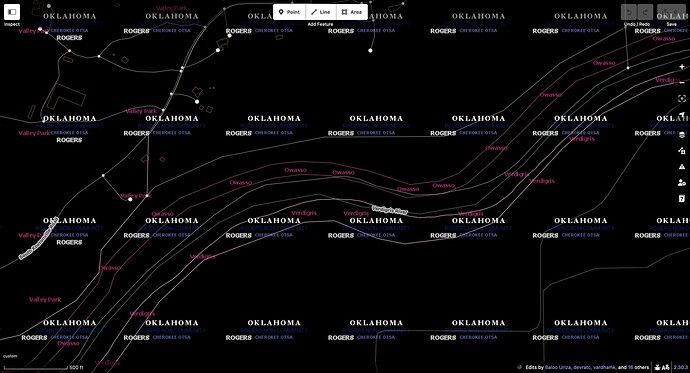
The City of Owasso and Town of Verdigris have each annexed a narrow strip on their respective banks of the Verdigris River, but not the surrounding countryside. These strips, which don’t necessarily follow parcel boundaries, are a quirk of Oklahoma law called a fenceline. Fencelines can create unincorporated enclaves larger than the entire incorporated area of the municipality. Owasso has published a fenceline map that corroborates what’s in OSM, at least at 1:126,720 scale.
As you alluded to, these boundaries were originally imported from TIGER 2008 and haven’t been modified since. Overlaying TIGER 2024 boundaries,[1] we can see that the Census Bureau has redrawn Owasso’s fenceline so that it more closely hugs the northern banks, an average difference of roughly 150 feet (45 m). Meanwhile, Verdigris continues to extend into the river. (You can also explore these boundaries interactively on the Census Bureau’s data portal.)
Someone with plenty of spare time could rummage through older versions of TIGER and Esri Wayback imagery to determine whether the northern bank moved in reality or whether it was just a data cleanup. Someone with plenty more spare time and luck with the staff at City Hall could obtain the relevant legal descriptions to determine whether the Census Bureau’s Boundary and Annexation Survey got slightly incorrect data from the county GIS department. (It wouldn’t be the first time.)
From what I’ve seen so far, I have no reason to assume that the Owasso and Verdigris boundaries should touch along this stretch of the river. Even if they did, the boundary line would be unlikely to precisely follow the river centerline as drawn in OSM.
If only we could simplify the real world as easily as we can simplify ways in JOSM.
https://tigerweb.geo.census.gov/arcgis/rest/services/TIGERweb/tigerWMS_Current/MapServer/export?dpi=96&transparent=true&format=png32&layers=show:20,21,24,25,26,27,28,29,30,31,34,35,36,37,40,41,42,43,44,45,46,47,48,49,50,51,52,53,80,81,82,83&bbox={bbox}&bboxSR={proj}&imageSR=102100&size={width},{height}&f=image↩︎
