I would like to map my city’s wards in OSM. I see on the Wiki that boundary=political is already well-defined, great! And I’m very comfortable working with boundary relations already, so I know how I’d map these in general.
Normally, I’m of the stance that administrative boundaries do not snap to non-administrative features like roads or landuse. But here, these wards will follow the outer boundary of the city itself, changing as the city annexes and deannexes property.
They have no real administrative function apart from the city itself, which is why I’d rather they be mapped as political boundaries, but they otherwise should remain consistent with the city’s boundaries.
I’m considering splitting the city boundary ways so that individual ways can also participate in the ward boundaries.
What do you think?
It’s okay for ways to belong to both admin and political boundaries
Even if this were not the case, the ward boundaries should follow whatever they’re defined by, and if they’re explicitly defined by reference to some other feature (whether a boundary or a boundary marker), there’s value in recording that relationship by connecting the boundary way to the feature. When two boundaries mostly align but don’t connect or share the same ways, users have to assume that’s because the boundaries haven’t been cleaned up in real life either.
The general sentiment against gluing boundaries to roads or landuse areas is partly a reaction to poor editor ergonomics, and partly a reaction to mappers frequently jumping to conclusions about the relationship of features that look like they’re supposed to be aligned but aren’t in reality. Many feel that recording those relationships between the boundaries and real-world features is not worth the hassle. But I don’t think this sentiment extends to unconditionally keeping boundaries apart from each other.
If these are to be mapped I’d say connecting boundaries to other boundaries is totally fine and desirable.
I didn’t know about boundary=political and I have to say I’d prefer to not have electoral districts like this in OSM. My city is divided up into wards for city council, districts for the state house of representatives, and districts for the state senate. Each of these three electoral districts have different boundaries and they all change every 10 years with the population. I’m quite glad these aren’t in OSM as it would add a lot of complexity and keeping them up to date would be a lot of work.
That’s fair, and for the larger features I would definitely hesitate before adding them to OSM. I don’t mind keeping up on my local area, but who’s going to take responsibility for state / US house districts? It’ll just be another tiger:reviewed situation, but one that’s a lot harder for the average mapper to deal with. Probably why a lot of municipal boundaries are still in dire need of fixing from their original census import.
Being on the smaller side, the cities around me don’t change their ward boundaries much. I feel they don’t represent as much “upkeep debt” as broader imports often do.
I also find that at the very local scale, those features are harder to find. State and nation-level electoral boundaries are easily found elsewhere. But Plano, IL’s wards? As far as I can tell, there’s just a jpeg from 2008[1], and that’s it.
I could wait around for them to make the data more accessible and as a real GIS dataset, or I could make sure that the information is at least somewhere.
Which includes a bunch of neighborhoods that never got built. 2008! ↩︎
What did you expect to happen? Worst of OSM is a work of satire at best and a collection of potshots at worst; it isn’t a bug reporting system.
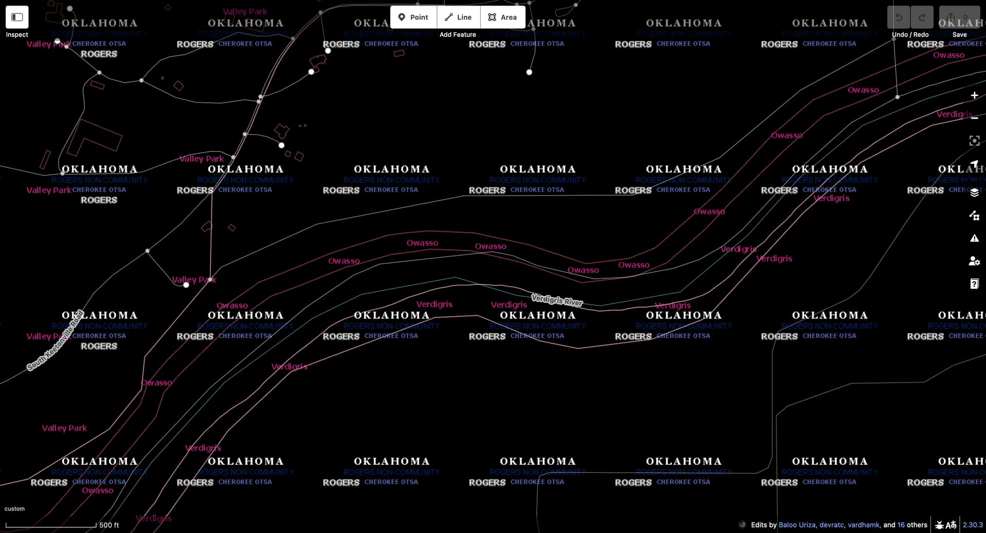
The City of Owasso and Town of Verdigris have each annexed a narrow strip on their respective banks of the Verdigris River, but not the surrounding countryside. These strips, which don’t necessarily follow parcel boundaries, are a quirk of Oklahoma law called a fenceline. Fencelines can create unincorporated enclaves larger than the entire incorporated area of the municipality. Owasso has published a fenceline map that corroborates what’s in OSM, at least at 1:126,720 scale.
As you alluded to, these boundaries were originally imported from TIGER 2008 and haven’t been modified since. Overlaying TIGER 2024 boundaries,[1] we can see that the Census Bureau has redrawn Owasso’s fenceline so that it more closely hugs the northern banks, an average difference of roughly 150 feet (45 m). Meanwhile, Verdigris continues to extend into the river. (You can also explore these boundaries interactively on the Census Bureau’s data portal.)
Someone with plenty of spare time could rummage through older versions of TIGER and Esri Wayback imagery to determine whether the northern bank moved in reality or whether it was just a data cleanup. Someone with plenty more spare time and luck with the staff at City Hall could obtain the relevant legal descriptions to determine whether the Census Bureau’s Boundary and Annexation Survey got slightly incorrect data from the county GIS department. (It wouldn’t be the first time.)
From what I’ve seen so far, I have no reason to assume that the Owasso and Verdigris boundaries should touch along this stretch of the river. Even if they did, the boundary line would be unlikely to precisely follow the river centerline as drawn in OSM.
If only we could simplify the real world as easily as we can simplify ways in JOSM.
Kind of. As the name implies, a fenceline is a tactic to keep a neighboring municipality from encroaching on territory it wants to expand onto in the future. However, there’s a process for the affected property owners to force the city to move the fenceline so that they can get annexed by a different municipality, something that a national government would hardly conceive of.
Another difference is that a fenceline has a definite shape and size, whereas precise whereabouts of each corner of each dash of the Nine-Dash Line are essentially unknowable. (That said, the PRC’s Ministry of Natural Resources does require a particular line width and dash length at several scales as a condition for approving any map.)
Creative annexations aren’t unique to Oklahoma. Some California cities, such as San José where I live, were once notorious for intentionally spreading “tentacles” across the countryside to block neighboring cities from growing, until the state reined in such abuses. Now the focus is on filling in the “islands”, of which only a dozen or so remain.
@reventnoticed that Gilbert, Arizona, did something similar to a fenceline in the 1970s, leading Arizona to ban the practice. He has also encountered some incredibly fragmented municipal boundaries throughout Alabama as he redrew them based on legal descriptions. For example, Hayden gained hundreds of exclaves that TIGER erroneously omitted.
So be careful what you wish for: cleaning up an import might well make boundaries even weirder.
Interesting. Sounds like a strange workaround for a municipality to essentially establish a proclamation boundary. Except they have to actually lay claim to a narrow strip of land to do it. So bizarre.
Yes, that’s a good analogy. California’s solution was to impanel Local Agency Formation Commissions (LAFCOs), which establish spheres of influence beyond which a municipality may not expand. In Southern California, someone mapped many of these spheres of influence as administrative boundaries, which caused confusion until we figured out what was going on. We’ve been retagging them as boundary=planning, for example in Palm Springs. However, I don’t recommend this approach for Oklahoma’s fencelines, because they are bona fide municipal boundaries, odd as it may seem.