Some naturalists who have posted observations of notable trees on iNaturalist like to also add the locations of the most notable ones to OpenStreetMap. If this topic is of interest to you, please see the following discussion on the iNaturalist Community Forum:
Note: I initiated that discussion (username Quercitron on that forum).
I disagree that we don’t want ‘boring’ trees on OSM. London Planes, for instance, can determine the ambience of places (e.g., la Devesa in Girona), and their loss to disease along the Canal du Midi is mourned. Quite besides which it is often much easier to map all trees than to use some arbitrary selection criteria. This becomes even more useful if one returns & some have been felled. I have actually used trees I’ve mapped to locate insects which attack the foliage when there was a very limited number of observations in the UK.
Mapping trees has multiple purposes: searching for species-specific pathogens (fungal or animal), shade calculations, 3D modelling, calculating CAVAT.
Various Tree Registers have been documented on the OSM wiki for a number of years. Tree Registers are very useful, but quality, especially identification & how up-to-date they are, can be issues.
iNat’s insistence that planted species are “Casual” records means that they will not necessarily get validated, so saying that OSM is worse is probably not true for many street & park trees.
The work of Awo mapping trees in cities in Chile, mainly Valdiva is in my view exemplary.
various blog posts of mine: tree trails, mapping using Obbsmap (an iNat competitor). Note: I dont use the latter approach as position of trees is not good enough, and I suspect the same with iNat, and now I prefer to use a dedicated OSM editor (Vespucci or EveryDoor)
talk I gave at a TDAG workshop 18 months ago, you have to search to find the entry.
Cluttering up the OpenStreetMap database with lots of Callery pears, London planetrees, and Eucalyptus along streets, for example, would not be a good idea, timewise and otherwise.
My impression is that mapping all or most of the street trees within a city on OpenStreetMap is discouraged, with the preference being to map a selection of distinctive ones. But perhaps that impression is a mistaken one. Mapping distinctive trees along streets on OpenStreetMap does seem a good idea, even if some are London planetrees.
Oh, that simplifies things - and mapping trees in such case is welcome and without extra potential complexities!
The OpenStreetMap community does have precedents and preferences for which trees should be mapped
I would say that basically all can be. Though mapping individual trees in forest is unlikely to be treated as a good idea, in cities you can (if you want) map basically each individual one. Though limiting to more important ones is almost certainly a good idea.
Seeing as though OSM “observations” are not accompanied by visual proof of a tree’s presence at the given coordinates, it would be difficult to verify the legitimacy of those observations.
You can add wikimedia_commons to link wikimedia commons image (or image to link freeform url with image but that is far less useful)
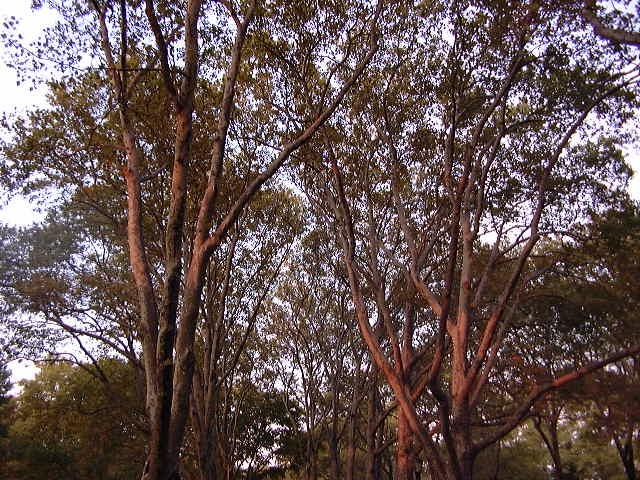
I feel obliged to mention that some years ago during a long walk through the Greenpoint neighborhood of Brooklyn, I happened upon Monsignor McGolrick Park. It was magnificent, with people sitting on benches reading books, children at play, and senior citizens at tables playing chess, all under a canopy of tall trees reaching for the sky - and most of those beautiful trees were London planetrees.
Let me not become known as a person who fails to appreciate London planetrees.
The topic of what vegetation to plant and maintain in cities is an interesting one, but risks diverting us from the original intent of this discussion. However, if someone were to initiate a discussion about that on the iNat forum, I might be tempted to participate.
Returning to the original intent of all this, namely …
… A visit to McGolrick Park via OSM’s Overpass yields many of these for the London planetrees:
There are lots of similar nodes such as that immediately to the west of Queens College (NYC). In that case, I happen to know that many of those trees are pin oaks (Quercus palustris), but would not edit those records myself without verifying identities of each tree in the field.
How do we encourage more people who map trees on OSM to provide species or at least genus information?
Unlike Google Streetview, whose licence prohibits the use of its street photos for mapping in OpenStreetMap, Mapillary is a good tool for remote mapping (although on-the-ground mapping is always preferable).
If you can identify Quercus palustris (or others species) from these street photos, feel free to add the following tags:
For my part, I have a question: what would be the best ways (tags) to make the link between the 2 platforms (in this case, the link to an iNaturalist observation from OSM objects).
Here’s an example of a tree, already present in OSM, that I’ve just completed from an iNaturalist observation :
Do you see better tags than source and photo ?
Perhapse ref:inaturalist=141365761 (but I suppose it would be worth documenting this tag ?)
A source or photo tag might loosely serve the purpose, but neither is a perfect fit. The source tag might suggest that iNat is the origin of the information that is being used as a primary basis for placing the tree on OSM, but if there are other reasons for doing it, such as a field observation, that tag does not work. The photo tag doesn’t quite fit either, since an iNat observation is more than just a photograph.
That seems a more direct means of correlating an iNat observation with an object mapped on OSM.
So, before proceeding with your proposed solution, I though it best to look around the OSM Wiki for preexisting mechanisms that could serve the purpose. A search on the Wiki for “iNat” yielded no results, so I though it best to check, with some skepticism, the following:
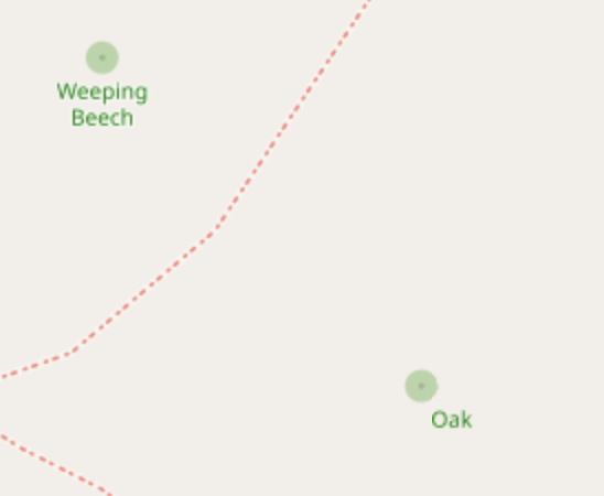
I have mapped a Black Oak (Quercus velutina) on OpenStreetMap and posted an observation of it on iNaturalist. Please see the following, and feel welcome to offer suggestions and comments:
" Black Oak is the common name for Quercus velutina." - so it is not name of this specific tree but of species? In such case it should go to species:en, name field is only for name of the specific tree.
But now it is only labeled as “Oak” on the map. It would be more interesting if it were designated with a more descriptive name, such as the original “Black Oak” like the nearby “Weeping Beech”. The label changes at different zoom levels.