From time-to-time some discussions arise in changesets and I thought that I’d consolidate Estonia-specific knowledge here. There are many nice wiki articles related to cycling infrastructure, but I wanted to write about how it all relates to Estonian reality. This is how I map, but I hope that it kind be sort of a guide. It’s my personal opinion, though, not a rule. Your opinion is welcome.
Any other bicycle-related OSM discussions are welcome here too.
OSM is currently the best data provider for cyclists in Estonia and I believe in many other places.
Layers like CyclOSM, OpenCycleMap, and apps like OrganicMaps, Komoot, brouter make it easy to consume it.
We have beaten Google Maps, isn’t that great? Let’s keep it that way!
Cycleways
Pure cycleways are simple highway=cycleway, maybe with bicycle=designated.
For cycleways which feel like a part of the road without much separation I usually don’t create a separate highway and add cycleway=track to the existing carrigeway. But I’m not against having it separately mapped, just make sure you remove the cycleway=track and check cycling map layers when editing.
Combined bicycle/pedestrian paths
But pure cycleways are rare. What we often get are combined bicycle/pedestrian ways. And there are multiple ways to map them.
-
Many mappers including myself prefer to use
highway=path + bicycle=designated + foot=designated
highway=path isn’t only about forest paths: Tag:bicycle=designated - OpenStreetMap Wiki -
Unfortunately, iD editor has a different template:
highway=cycleway + bicycle=designated + foot=designated
Which puts emphasis that the way is for cyclists. -
[AVOID!] You can encounter highway=footway + bicycle=designated in some places. This is not a well documented approach. Let’s not make it more complex for consumers. For example, Komoot isn’t sure how to consume it and renders it as a footpath. Even though some places do look like a footway with a combined bicycle-pedestrian path sign slapped on them.
It’s better to also add surface=asphalt right away to help renderers, routers and, especially in highway=path case, make it clear that it’s not a forest path.
What if it’s a sidewalk and a combined bicycle/pedestrian way? Surely footway=sidewalk belongs on a footway! Well, not really.
footway=sidewalk + highway=path + bicycle=designated + foot=designated
is a perfectly valid combination.
Unless I’m editing other tags I don’t convert highway=cycleway to highway=path. It would be a useless edit war if we just changed it back-and-forth without any useful changes.
Footways
Adults are discouraged from cycling on footways. The law is not being very specific here on exact situations when exclusion applies [LS § 32 (2)]. It’s also not really enforced unless accident happens. Still, as long as there is a safe alternative way, we shouldn’t add any tags to footways. I believe that pedestrians should be comfortable and safe on their paths. Routers mostly avoid footways, this means there is no need to put bicycle=no on footways unless there is a specific sign. Besides, some groups of people are specifically allowed to use footways for cycling [LS § 32 (3)].
I think that it’s ok to add bicycle=yes when there is no alternative for a cyclist who would be afraid to use the carriageway.
Carriageway (Sõidutee)
By default, bicycles are allowed on a carriageway [LS § 32]. Unless there is a sign which specifically forbids cycling no attempt should be made to set bicycle=no or bicycle=use_sidepath. It’s up to the routing software and cyclist’s own judgment to select a route.
Crossings: Access and routing
First of all, it’s allowed to cross crossings on a bicycle [LS § 32¹. (3)]. This means that if crossing is mapped as a way and it’s is connecting paths where cycling is allowed, then for routing it’s important that the crossing has bicycle=yes or bicycle=designated tags.
How to choose between them? While there is no real difference in the law, I’d use the road markings to decide this: regular zebra (945a) is a yes and 946a, 946b, 946c, 946d, 948 are bicycle=designated. Sign 557 can also be used to decide if a crossing is designated. Though it’s sometimes incorrectly used to warn drivers of a non-one-way bicycle traffic on an otherwise one-way street.
If the crossing doesn’t connect ways where cycling is allowed, then there is no need for bicycle=* tags.
Trails in nature
Sometimes people use access tags to mark ways which are in their opinion not accessible by bicycles. But we should remember that access tags are about legal access. Moreover different people have different skills and different bicycles. Try to use MTB scale for difficulty. It’s not always possible though. How to map a boggy path? Or a path with obstacles no one can’t overcome on a bicycle? These questions remain unanswered for me.
Use common sense!
There is usually not enough signage and road markings to understand when a combined bicycle-pedestrian path ends and a footway starts.
There may be contradicting road markings and signs and while the law says that signs override road markings, the road markings are correct and signs are wrong! Here there are both bicycle-pedestrian segregated road markings and a footway sign.
Sometimes signs are put for cars without thinking about cyclists.
Also, there exist signs which are not really a part of the law, as far as I know, which may or may not require a bicycle=dismount depending on your judgment.
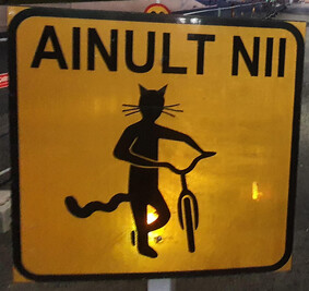
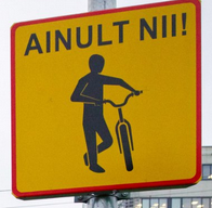

(what’s the deal with cats?)
Another example is Tallinn song festival grounds, though I don’t remember if they currently have only a warning sign or also an additional text “descent forbidden”.
Some common sense is required to resolve such situations.
Connectivity
Check that everything is connected if it’s connected in reality. Bike lanes merging into a separate cycleway need a connecting way between carriageway and a cycleway. This allows to use routing applications.
My experience is mostly Tallinn and rural areas, if you have something to share about your town, be my guest.