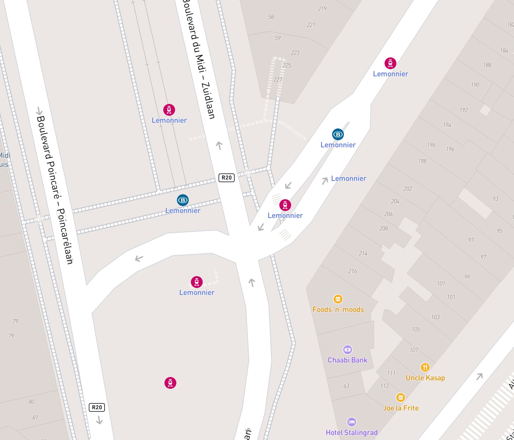
Hello. As you can see in the picture below, the Lemonier Premetro station is also labeled as a train station when customizing the icons in Mapbox. This issue is also present for Annessens, Debrouckère, Rogier, Diamant & Meiser stations. The source of the data is supposed to come from OSM. Does anyone have any ideas on how to remove these labels in the source map? I submitted a ticket to Mapbox, and while they told me they resolved the issue, it is still displaying incorrectly
The nodes that show up with the NMBS logo are tagged as an MIVB/STIB station=tram, but station=tram was undocumented until just now I added it to Key:station - OpenStreetMap Wiki.
To the Belgian OpenStreetMap community:
I propose to use station=subway instead of station=tram. These stations are in a part of the premetro system that is built to subway standards (i.e. separated from traffic), and they look and quack like regular subway stations.
To Mapbox:
My guess is that Mapbox doesn’t recognize Clarified by @NEONLOVE belowstation=tram, and considers all railway=stations that don’t have a station=* that they recognize as a train station. They should change their software to be more conservative when they don’t recognize the station=*. Besides, there is also an operator=STIB/MIVB tag on these stations. Don’t go showing the logo of someone else when there’s an operator tag!
1 Like
Premetro station are something very unusual indeed.
From the outside, they look like regular metro stations and show the same “M” logo as ordinary metro stations elsewhere in Brussels. Inside the station, platforms are of full dimension because they have been designed with a future conversion in mind—and incidently this conversion is about to take place within a few years—despite they are served by trams (the infrastructure is tagged with railway=tram, route relations with route=tram…).
What worries me most is that Lemonnier and Boileau stations have the same tags (public_transport=station, tram=yes, railway=station, station=tram, operator=STIB/MIVB), yet Mapbox renders the first one as an NMBS/SNCB railway station and the second as a tram station.
I agree with M!dgard: showing the logo of another company makes no sense.
1 Like
I believe I must clarify something.
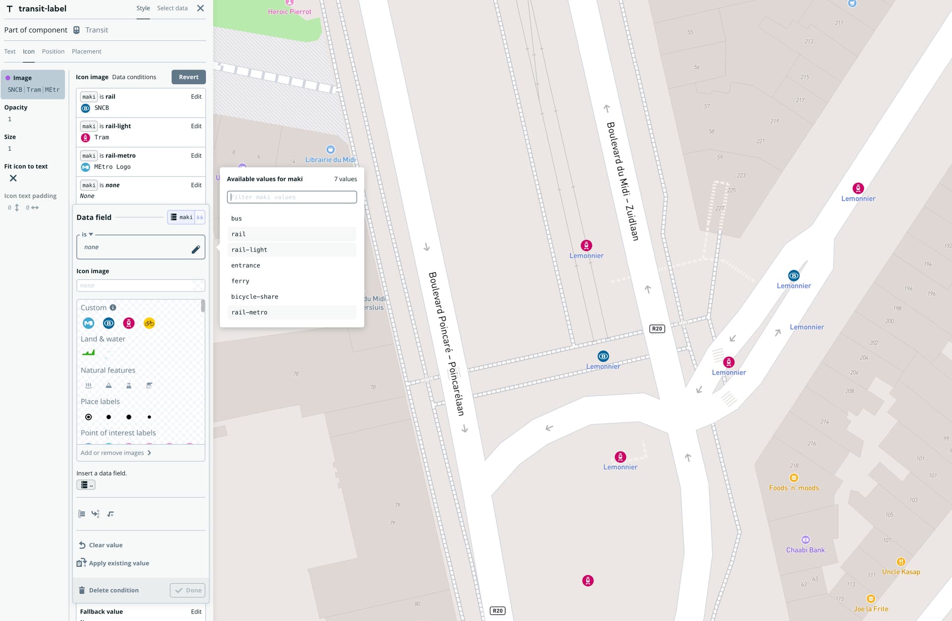
On the default Mapbox Map, the SNCB logo doesn’t appear; instead, it displays an icon representing a train. This same icon is used for trains and PreMetro stations, as shown on the following link.
The SNCB logo becomes visible when I specify to Mapbox which icon to use for the different categories, as demonstrated in the image below.
Sorry if I created any confusion.
1 Like
Thanks for clarifying.
I’ve changed the premetro stations to station=subway now. But Heizel has a real tram station, so Mapbox should consider recognising station=tram too.
I disagree with the change. Tagging for the renderer—or one particular renderer—is a bad idea. This should be preferably solved by MapBox. Using station=subway with *=tram objects across it makes really weird tagging.
Consider other uses of the tag. if I’m looking for a tram stop, a pre-metro station is very much not what I expect, when they look like metro/subway/underground stations. It is only when a tram rather than a train appears that the casual visitor would notice the difference. I support marking them as subway stations, and am slightly amazed that it’s still a pre-metro (I first used it around 1985).
Note that, Antwerp, at least, also has pre-metro stations including Groenplaats (which I first used in 1976). I’d be a bit more ambivalent about the Antwerp pre-metro because it is entirely a tram network, but the major stations have much more of a feel of metro stations rather than tram stops.
At least one Manchester tram stop (Piccadilly) is constructed like a metro station as well.
In the Brussels and Antwerp cases entrances to these stations are tagged with railway=subway_entrance, which also suggests subway as the station type. Access to these, particularly for people with limited mobility or sight is a very different matter to access to the platforms of a typical tram stop.
1 Like
I must say I’m amazed by this forum; what a passionate community! ![]()
I suppose my questions may be slightly off-topic, as they may only fulfill one of my wishes. I’m interested in the ability to edit Mapbox maps without the need for patch layers to cover display mistakes. After reading your posts, I’m wondering if labeling them as metro stations might be the best solution to bring the maps closer to reality? When walking around, you always see the Metro logo at the entrances.
I’m not sure how to exert pressure on MapBox to make these changes or how long it will take for the changes you’ve suggested to be implemented in Mapbox. I’m new here and still discovering the potential of this wonderful tool.
Best regards
In agreement with @SK53 I consider these to be more “subway” stations than “tram” stations, not just for the renderer. tram is also not completely correct for our premetros: the parts where they go underground are not really tram lines. Specific tagging for premetros in an option, though I worry it may be a bit too specific: according to List of premetro systems - Wikipedia there are only a handful.
I do agree that station=subway with *=tram is weird, but I don’t find it problematic. However, I did the change to subway opportunistically and can roll it back if need be.
Along the same line, Germany has a lot of similar stations, except they call them U-Bahn. In OSM, they are using tram station even undergound (Köln). In this case, I’d use metro because the STIB is marketing it as such and it should be transformed into a real metro anyway in a few years, once the works are finished in schaerbeek.