Whew, for a second there I thought I should finally get around to fixing Apple’s website or coding a new browser for Linux users.
I asked Google to ask Apple to stop blocking Chrome on Linux,
https://issues.chromium.org/issues/416620769
Thanks; but I wouldn’t suggest holding your breath…
Gosh, now there goes 15 years back on memory lane and it’s foggy, it used to be possible to fake the identity of the webbrowser i.e. it being Chrome but telling the visited site it’s e.g. Safari.
Finally!
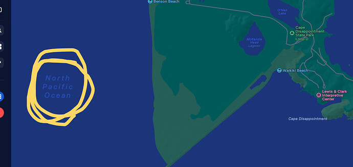
We are at Cape Disappointment State Park, and all we want to know is the name of all that water we see.
https://maps.apple.com/frame?center=46.28%2C-124.09
achieves this without needing to zoom out.
(Seen on a Chromebook.)
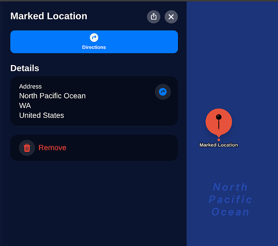
It turns out to be an idyllic ocean,
https://maps.apple.com/place?auid=3617963108949840202
Largest ocean too, it tells us.
So… time to close this thread?
Firefox, as a Linux user I wouldn’t touch Chrome with a 10ft barge pole
But Looking for the Pacific Ocean - #59 by Matija_Nalis already tested that and it got the same error.
So… time to close this thread?
True, I finally found the Pacific Ocean. But it was only in Apple Maps.
But it was only in Apple Maps.
So you weren’t able to find the time to follow my suggestion from a couple of weeks ago ![]() ?
?
Interestingly Apple Maps are using OSM data (among other sources). Whether that separate page that meets the requirements has been much discussed elsewhere.
(obviously I’m using Firefox’s “User-Agent Switcher” add-on to get around Apple’s ridiculous browser restrictions here)
(obviously I’m using Firefox’s “User-Agent Switcher” add-on to get around Apple’s ridiculous browser restrictions here)
Oh, I think I’ll somehow manage to live without Pacific Ocean on high zooms then.
I prefer not to engage in circumventing technical protection measures set up by party actively hostile towards my intent to access their website, and instead skip dealing with them altogether.
Seems like a sensible advice generally, and especially if one prefers to avoid being classified as a criminal by a country whose leadership lately seems to be quickly steering it in the direction which historically didn’t end well for people declared as the enemy of the state…
I don’t think that the first statement is objective.
The majority of OSM data usage is likely from large companies like Facebook, Apple, Lyft, Uber, Amazon, etc. The standard layer is “only” viewed by hundreds of millions of people a month.
The second statement makes no sense
Speaking as a former OpenStreetMap Carto maintainer, the OSMF does not have the right to dictate how OpenStreetMap Carto is designed. Someone else using the OSMF’s tile servers doesn’t have a right to dictate how the tile servers are run or how the style used on them is designed.
I was just thinking that a easy solution would be anything off the west coast of North America and South America one could label the specific ocean, I mean Pacific Ocean, I’m using voice input. Please excuse me.
Except, let’s say you’re up in the north part of the Gulf of California. Well labeling that the Pacific Ocean would be quite misleading. So I guess it’s back to the drawing board.


