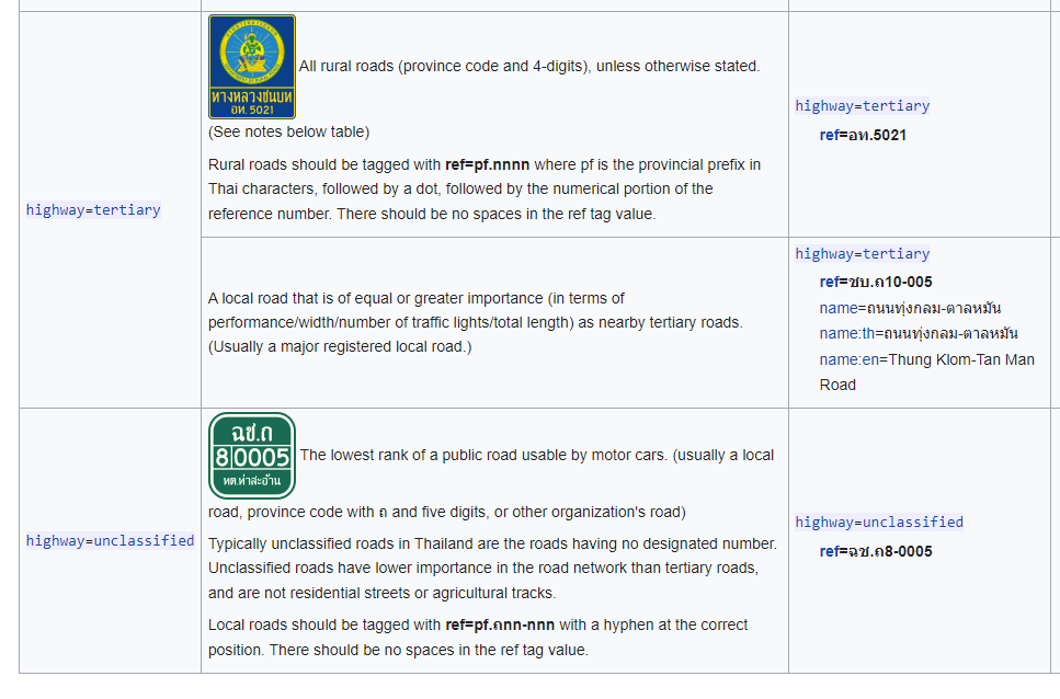
Local Road Ref. Problem

Problem

Under the current scheme, all registered local road ref (xx.ถxx-xxx) should be tagged as ref=* even if it is not signposted. This would clutter both routing and rendering with a useless ref. Inconsistencies can also be seen. The urban area is an excellent example, as some municipalities have registered even for small sois, while some others have yet to register any road at all. However, 99% of the municipality does not have any reassurance marker signs and has no plans to do so. Only the road name is used for communication and it is usually signposted.

For the international approach, unsigned_ref=* is currently used for administrative ref that are not intended to be recognized by drivers (but don’t need to have no sign at all). official_ref=* is also used, but it is less common and has no clear distinctions.

Solution

How do you think we should handle this problem?

  1. Tag all local roads’ ref as unsigned_ref=*. (easiest to do, but will lose a lot of information)
  2. Tag only local roads with a reassurance marker with ref=* , else unsigned_ref=*. (situation on ground is important, and can be changed easily)
  3. Tag only local roads with no name* with ref=* , else unsigned_ref=*. (the name have to be researched)
  4. 2+3, if the road is signposted with a reassurance marker, always tag it with ref=*. The name have to be checked only if there is no reassurance marker. (giving at least some information to a routing software, for a rural road with no name, might be better than nothing being displayed)

(*Officially, every registered local road must have a designated name in the DRR database, however these “name” just describe the start and end of the route and are never used for addressing. This kind of “name” should not be considered a name.)

not true

we have Key:unsigned_ref - OpenStreetMap Wiki for unsigned or barely signed ones (with reassurance marker)

@Mateusz_Konieczny I believe the statement “should be tagged as ref=*” refers ti the tagging scheme outlined in the wiki:

https://wiki.openstreetmap.org/wiki/WikiProject_Thailand#Highway_classification

This “ref” question is just another incarnation of the problem we face with finding a tagging scheme which is working here.

While inter-province or inter-city connections, especially on the higher road classes are relatively clear, it gets tricky once we enter into the very urban areas, especially in Bangkok metropolis.

In the past, the tagging scheme was relatively simple. The lowest road class was a tertiary. It was recognized by four digits and a province prefix.
Now, that we have some sort of “internal” reference as well for the more local roads of type “unclassified” and based on this recent post, even for residential roads, it gets tricky.

I agree that it makes no sense to have reference numbers included for a residential road, if the sole purpose is to have this reference somewhere in a database where the road maintenance department uses it for their purpose.

For easier reference, here the section of the wiki.

So if for local roads the ref number has no practical meaning, then I think we should not put it into the ref tag.

Throwing in another tag for discussion: Key:highway_authority_ref

How about that one for all highway=unclassified and lower which have one of those long refs of the DRR database?
Maybe it is even all of them with a dash in the reference number? We frequently referred to roads by their ref number, but I have never done this for a road with a dash. So either this is because this is not common, or such roads are not that frequent around Chiang Mai.

Would you expect the speech guidance of your satnav to announce to turn into ชบ.ถ10-005? Would that be visible on the road signs above the road indicating the next turn? If not, then it might fall as well in this category of more “internal” reference numbers.

Since some of them is clearly visible, such as this example, they are useful information that should be kept in ref=* and used for routing, so we should have some criteria to decide which ones to keep.

(I have found a few of them signposted before the turn, together with the national highway, but I can’t find it now)

Maybe the sign is then the key? If it is signposted, then add to ref. If it is only known by this number in DRR database, then place the id into highway_authority_ref?

Would also bring us closer to ground truth again
And it would only apply to these refs with dashes, not the four-digit ones. I would still tag them, even if for some reason the milestone is not there any more or hidden.

Right, the rural roads (four-digit with province prefix) have nothing to do with this issue.

And, how do you think about the registered local road without a name? Does it worth having the ref in the ref=* tag, (even when there is no sign), or should the sign be the only criteria to keep things simple?

For the tag, there are currently unsigned_ref=* , official_ref=* , and highway_authority_ref=* , and I don’t see a clear distinctions, so I suggest using unsigned_ref=* since it is the most popular.

In case there is a local road, for which a ref exists in DRR data-base, but there is no sign-post, and people usually refer to the road by a name and not the ref, I certainly would not insert the number into the ref key. The highway_authority_ref=* sounds for me like a good target for the ref.

But: I personally would not tag the ref number at all in such a scenario. It is quite hard to validate the information. By survey, probably not possible at all. And I see not much use to re-create the DRR data-base inside OSM. In case someone still wants to map these (internal) details, then the above mentioned key might be the right one.

I would tag the reference number also for a local road as in your example above into the ref key if it is clearly having such a number as in your example.

Can you give some examples for the scenario you mentioned: A local road without a name, but registered (so I assume having a ref, right?)

Way: 80649497 | OpenStreetMap , for an example. Most registered local roads in rural areas are in this condition.
(Yes, registered = having a ref.)

(Technically, all registered roads have names, but as I said in the post, these names are simply used in the database to identify the beginning and end of the road. Nobody used these names.)

What I’m not sure about is whether the routing software should provide the driver a name, a ref, or nothing at all on these (many) roads with no signposted name and no signposted ref.

I am not familiar with routing implications but I think it’s important to store the local road ref (e.g. unsigned_ref) when it’s known because it has a direct effect on the choice highway classification (unclassified). Without this ref or local knowledge, this road may be changed to a lower classification (e.g. residential).

Thank you for your feedback. After considering all of the comments and researching the wiki, I think that simpler is better. So, option 2 may be the best solution. I’ll update the wiki soon.

1 Like