Linking cc-by-sa 4.0 images via wikimedia commons or other URLS

Hi, after reading cc-by-sa 4.0 licensing and some discussions in the forum, I’m still not sure about the scenarios described below and would appreciate clarification:
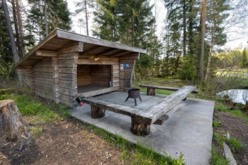
A user on swetrails.com has published information and images on hiking shelters (example) under cc-by-sa 4.0, so I can upload these images with the same license to wikimedia commons, with source and attribution of course. Here are some questions I have with respect to the license situation for using them for OSM (not on which tag to use):

A) Assume the shelter already exists as node or way on OSM.
What is the legal situation for the following cases:

  1. Linking to the URL of the original website showing the images as URL=example
    (Osmand would not show the image within the app)
  2. Linking images on the source site directly with image= example image (Osmand will show the image)
  3. Linking the wikimedia images with image= example image as either
    Page URL or File URL (Osmand will show the image)
  4. Providing the wikimedia_commons=File/Category: (Osmand will show all pictures)
  5. Looking at the pictures and extracting information about the properties of the shelters, let’s say material=wood, lockable=no, etc.

B) Same thing for shelters that are not yet in OSM. Do I understand cc-by-sa 4.0 licensing correctly that this would require direct permission from the copyright holder to use the coordinates and create the node?

1-4 would only link to the respective sources without extracting additional information. Why would one need a license for that on OSM to begin with? The images are not copied to OSM, no information is extracted. Would Osmand need a license to show them?
5 would concern information not mentioned in writing on the original website.

For all cases assume that the source= provides a link to the original URL.

I’m currently trying to get a hold of the creator of the images and could ask him to grant the license according to the waiver template, but I have to go through the contact page of the website and they may or may not forward my note.

Thanks and sorry for the long post.

1 Like

First of all, OSM routinely links to copyrighted, unlicensed material via website=*, image=*, and other keys, so if there’s anything against tagging these images in wikimedia_commons=*, it would be as a matter of project policy rather than copyright protection on our part.

If a data consumer uses wikimedia_commons=* to display an image, as opposed to merely linking it, it needs to determine the licensing information on its own. Fortunately, the Wikimedia Commons API can provide this information and more in structured form. Creative Commons attribution licenses are generally interpreted relatively flexibly. For example, if someone uploads their own work to Wikimedia Commons, merely linking to the image there satisfies the attribution requirement, though some older versions of the license allow the photographer to place more stringent attribution requirements on the work.

2 Likes

Thanks Minh! That helps a lot already. How about no. 5? I interpret your answer such that this is covered as well for case A.

The Osmand image display has a “Details” menu that they could use to show the proper attribution - once that works correctly.

For case B (shelter not in OSM), the situation for the website linked is that the author also gives a cc-by-sa 4 license to text published there, which I understand to include the coordinates of the shelters. I therefore include these coordinates in wikimedia_commons uploads of the pictures. It might be nitpicking, but this may not be quite the same as using the information to create a new shelter node in OSM based on that information.

For sources with images without any attribution except stating that copyright is with the (unknown) photographer:
I’ve seen discussions that we supposedly may not even describe what we see on plain google earth images (not talking about items mapped there) because these images themselves are copyright limiting. Is this correct?

On the one hand, there’s a pretty widespread principle that an individual raw fact is ineligible for copyright protection on its own. On the other hand, I wouldn’t go so far as to say that “extracting” details from a photo avoids copyright considerations.

Tracing roads and buildings from another map is definitely copying. Tracing the same roads and buildings from an aerial imagery layer is also copying. If you instead trace them from a photo taken from a hot air balloon, it would still be copying. If the photo shows the building’s wall because the hot air balloon hasn’t taken off yet, that’s still copying. If you have the photo side by side instead of overlaid, that’s still copying. If you’ve printed out the photo and refer to it on your desk while mapping… you get the idea.

In some jurisdictions, all these conceptual hops might add up to a fair use defense against a claim of copyright infringement, or even a determination that there wasn’t any copyright infringement to begin with. However, OSM is based in the UK, where there historically haven’t been similarly strong protections for reusers. And as a matter of project policy, we don’t want to rely on legal gray areas anyways.

This can be frustrating sometimes, since most of the authors you’d need to reach out to don’t have such a rigorous, pedantic stance on intellectual property rights. I’ve all but angered some local government agencies by pestering them about the copyright status of works they don’t really want to protect in the first place (but can’t say so explicitly). How ironic that it falls on an open data project to educate others about the importance of respecting legal barriers around data!

If you can, maybe ask the Swetrails user if they’d be willing to let you put this information in OSM without any restrictions, perhaps crediting them less formally in source=* tags or somewhere on the wiki. It’s easier for everyone than getting into the weeds of formal licenses and waivers. Like OSM, most crowdsourced sites have terms that allow contributors to retain ownership of their contributions, so they’d have the right to give you that permission.

Wikimedia Commons has different considerations due to a difference in focus, use case, and jurisdiction. Most of the coordinates on image description pages come from EXIF data encoded in the image, but some are manually entered more manually by Commons contributors based on their own geolocation efforts. More recently, Commons has started putting this information in structured form that’s explicitly dedicated to the public domain under CC0. Sometimes I use these coordinates to jump to the general location in OSM, knowing that EXIF data is only as reliable as a single stray GPS reading, and then I use my normal mapping skills to determine the actual location.

Correct, it doesn’t matter if you’re copying from Google’s basemap or their aerial imagery. It’s all copyrighted. Neither their terms of service nor OSM policy allows you to copy from either layer of theirs.

2 Likes

Indeed I do, well written.

that one too, thanks!! Most often the camera location is anyway not where the actual target is located.

I’ve written to them already, but no reply yet. Unfortunately I could not track any contact details of the original contributor.

That is what I did thus far with a link to the corresponding swetrails page but I just read that the “source” tag is considered historic - yet I think it is useful also in other context, such as conflicting reference IDs and names for objects (Lake IDS in Sweden are a mess, some are not even consistent across official websites). I’ll therefore keep using the tag.

That’s another one. Similar content is available on a commercial site does exactly that but does not credit their contributors nor provide a contact form. The said they would provide a contact if I asked them w.r.t. specific images. Which would be a very tedious process. I had posted a question on this previously.

Again, many thanks for you quick replies and help.