`lcn` tagging in Australia

@Migwell, (and others in Australia comitted to this endeavor): please take care to distinguish between a bicycle route and a bicycle network. I see you using the latter when it seems the former is more correct. A network is a connected set of routes.

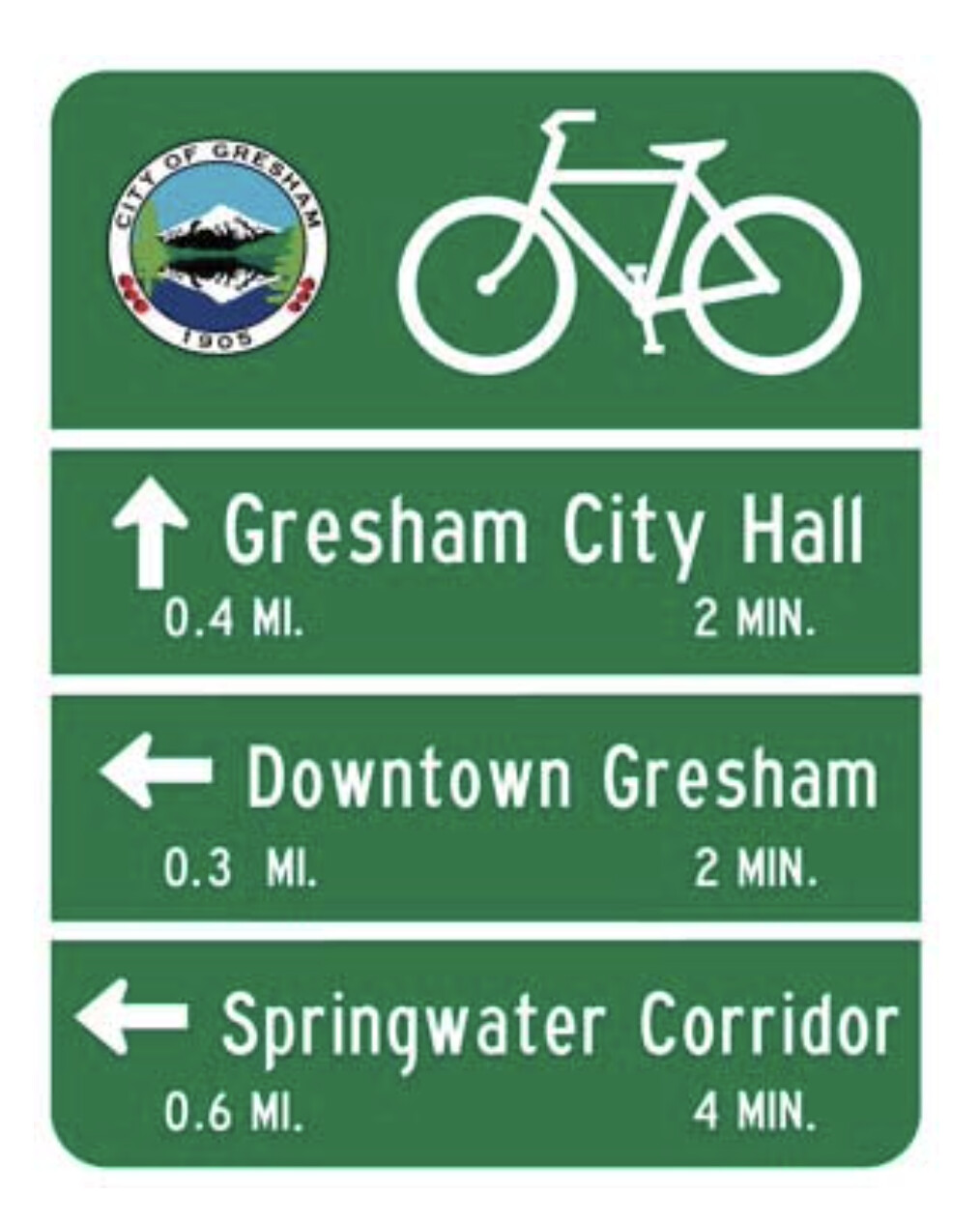
You appear to be able to map a “set of signs” (e.g. with directional arrows, a bicycle glyph and a destination, for example) that could or might link infrastructure for cyclists (but…does it?) as a bicycle route. These do not seem to have a route name or route number (for the ref=* tag), but they might; asking the local council seems a prudent step along the way to determining this (they put up the signs, they know whether there is a “network of routes”). This consultation would likely show how such (potential) routes aggregate into one or more bicycle networks.

Mapping infrastructure should be primary, mapping routes is an intermediate step, along with putting routes into (an often named) network, which (in a more-advanced sense beyond an intermediate step) coalesce together into networks at usually a national level (allowing international to “bridge” these, but Australia being its own continent / island / country, international is moot there).

These signs (from photos earlier in the topic) might also indicate something more like the Dutch- and Belgian-style node networks, or perhaps something akin to what might be called destination-based routes (forming a network) is what’s going on. Again, please consult with the local council to identify what they have implemented with this signage before making assumptions (and blurring a network with a route).

Remember: OSM maps bicycle infrastructure and we map (usually signed) bicycle routes. We also map (bicycle) signs, but how those form routes and/or a network or networks is particularly locally-defined. I urge you to determine (more widely) what is meant by those signs before you map routes (which appear to be local, given the topic title and that you are in Melbourne in the instant context).

I mean no harshness with what might seem like admonishment, rather, a “proper fit” between bicycle infrastructure, bicycle signage, bicycle routing and possibly bicycle networks in Australia comes from a comprehensive fitting together of all of these pieces (and their proper semantics). Thank you and wishing you the best in these endeavors!

Yes I agree that I’m talking about routes. Unfortunately the OSM tagging system conflates the two, and I’m inclined to follow this to reduce friction.

Recall that the current tagging guidelines say:

Local routes (lcn, lwn, lhn) are generally short paths and routes that are confined to a local area.

The key tag in question here is lcn, which I believe is heavily overused, but is generally used to mark routes.

Although asking the councils would be the most technically correct approach, it simply isn’t practical given how many exist and how frequently they change their policies. This is why the definition I have come up with relies on certain physical signage.

Mmmm, no. I either don’t believe this is true at all, or I genuinely don’t understand what you mean by this. What two are being conflated?

A route relation tagged network=lcn is a single route in a local network. There is no conflation or ambiguity at all there.

If you believe something (like lcn) is heavily overused, you might say so (and you just did, and I disagree), or make a proposal to correct it, or state clearly that there is some confusion about it, “and here is how.” But you do not, nor have you.

If “asking councils is correct,” then ask them. Don’t take shortcuts as to what is correct, especially if you are (re?)-defining things (based on your own misunderstandings?). If there are “many of something,” build them into OSM one at a time, like is done all over the world. I sincerely doubt that local councils “frequently change their policies,” as you haven’t offered any evidence that they do.

Just a whole heck of a lot of things going on here, to say.

I see overlap between the TravelSmart map and OSM data, which might have even been entered as deliberate desire paths for this specific purpose. Who knows?

Local councils really are behind what is meant by those signs. The fact they do or don’t publish a route map (or have those data as ODbL) doesn’t matter, the signs are reality. They mean something. In USA, we have the MUTCD, the Manual of Uniform Traffic Control Devices (the “book of signs” for the country). Signs mean something. “Local people say so with a sign.”

OSM tags reality. That’s it in a nutshell, but there is so much more to say.

The original concern that dangerous roads are built for a smart map, maybe yeah, OSM’s Australian community agrees we’re gonna clean that up (delete nonsensical data). AND, we’re gonna tag infrastructure with infrastructure tagging. And proceed with lcn tagging as we agree what we mean by that.

@aharvey is correct that hounding councils for perhaps dubiously-not-ODbL-compatible data in the long-run likely isn’t a winning strategy. What works is consensus from the ground up, and it seems like this is ground zero around here. I like Sam’s go-slow approach, that needs sharpening up how it goes, though. I agree with Peter (again); there is a balance between being aware and early (maybe sprinkling these into OSM) and being correct about it.

Here is an example (from the city of Gresham, state of Oregon, but it is typical of how I see these in California and other states, too):

I’d say several conversations are ahead: tease out differences between using lcn=yes tagging on ways and “graduating” to collections of these (a first level is to a relation tagged type=route and lcn=yes containing members ways which might also be tagged lcn=yes). It doesn’t all have to be built at once, though it should describe what is known and maybe a hint of things to come, if you are smart about it. Sam seems at an early, if not well-sharpened version of it, but it seems it must be absorbed widely. You already have plenty of tagging in -au of lcns, so there must be dozens? of people on it. Maybe Melbourne is having a melt-up moment, it happens; I haven’t my pulse on it but it looks like putting the chain back on. Those signs mean something…tease it out and tag it, you can.

Really, there is both “cleaning to slate,” and there is “right smack back to clean slate.” I envy that, because you get to agree how you’re gonna build it from the ground up, using ground truth, with tagging that says what is meant. Because we know what is correct, it is rather crisply tagged.

That’s how we do it, anyway. I see so much sincere effort here, everyone. I have read early wiki and see good measures towards good infrastructure tagging. Sign tagging of the sort of directional arrows with destinations / distances on them (and a bicycle glyph) like to Kew and Swinburne, well they “mean something” OSM can capture, too. Those might be local cycle routes which get tagged lcn, maybe, but just how? There are ways to do that, too, more like being in college than high school. Way tagging, lcn=true tagging, lcn=yes tagging, network=lcn tagging…they mean something different from each other. They render here this way, they render there that way. Be careful.

Whew, enough already.

If I can go back to your original motivation @Migwell. It’s good to discuss the use of lcn=yes on ways and type=route on relations, but keep in mind a proper signposted route can exist along a busy/dangerous road without any bicycle infrastructure, and we must still tag it as a route and not “tag for the rendered” by omitting the route over concern of it “appearing safer”.

This then allows researches, councils, government, the public etc to query OSM data to identify where there are routes which don’t have infrastructure and are on busy roads.

Each map and data consumer like CyclOSM and the routing engines can decide how they show/use bicycle infrastructure vs routes, the best we can do is get the tagging well documented and map things accurately per that tagging documentation based on what’s on the ground.

In this case you’re saying let’s not include lcn=yes or routes on ways without any signage on the ground, and I think that’s mostly okay since otherwise it’s just mapping peoples route suggestions (even if it is the local council’s route suggestion) and we don’t want everyone’s strava routes in OSM…

Here is another example Way: ‪Havilah Street‬ (‪4942038‬) | OpenStreetMap, there is no route name signposted, but the bicycle sign with an arrow and the painted bicycle pictogram on the road indicate it’s part of the local bicycle network, and it is then tagged lcn=yes which I think is correct. Then it’s not included in any route relation, because there’s no other details around start/end.

Very true, and I might make that more explicit in my definition. Safety could be inferred by the level of infrastructure, speed limit, parking in the lane, lane width etc but isn’t directly the responsibility of OSM to capture.

Agreed, this is a helpful demonstration of why lcn=yes will occasionally still needed.

1 Like

Nice, I could even sharpen up the focus: the sign probably makes it a route (relation), the sharrows are tagged on the infrastructure way they are upon (cycleway=shared_lane). This is one of those (rare, maybe) instances of a place / photo of both in the same spot. One tag on the way for the sharrows, another as the inclusion of the way (and who knows how many more OSM ways) in the (local) route relation of contiguous bicycle infrastructure elements, bidirectional or unidirectional.

When I do this, I know I am standing as tall as possible upon my tippy toes that I must get this seriously correct, every time I do this. Communities around me keep nudging it forward with us as we do. So I map accordingly. Many of us do this pretty much like that.

There is discussion over the last months about kinds of harmonization (I think you spell that with an s not a z) between rail and bicycle and and routing, it reverberates through Germany and Europe once in a while, last summer with a German person who emigrated to the USA and got confused about national bicycle routes (in North America) not “looking European.” To me, for example, Perth’s high-density national-level routes seem like a stark contrast to other cities on the continent; compare to Melbourne and Adelaide.

But what does this Yank know of such things, with my North American perspective?

I’m inclined to offer my perspective, fascinated with OSM, it is a remarkable project. Bicycle infrastructure and routes continue to grow in OSM, yeah.

Solid red national route you have along your east coast, looks awesome in OpenCycleMap. Cheers, mates.

A follow up to this in the United States community: San Francisco bike routes about San Francisco having BOTH a signed numbered local cycleway network AND (newer) destination-based signs. The latter are not especially dissimilar from the signs in Australia shown above (the “arrow / pointer” -style signs).

I’d be curious if OSM wishes to enter into our map data these signs, how we might do that (in a worldwide-friendly method) and whether these form what might be called a local cycleway network (of destinations, not routes), but which can (because of the existence proof of San Francisco) co-exist as BOTH a network of routes and destinations. Or, as it appears in the case of Melbourne, exist (only) as a “network” of destinations, but not (necessarily) numbered routes.

Thank you for reading.