More of a ‘who does it’, found the below image after a double power out destroying my JOSM preferences and settings, reporting that the preferences backup was broken too.
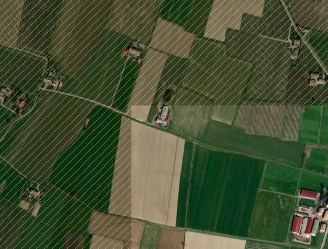
After vigorously rebuilding, fortune of having had a recent GitHub report listing all the map paint style and plugins installed to help, suddenly found this puzzling diagonal pattern in the edit screen, thinking that JOSM somehow could not fetch the image tiles until it dawned that it actually shows what data area was and was not downloaded. Looked very long for such a feature as too often in landuse edit frenzy drifted into mapping plots that were already mapped and then getting overlap error messages.
Regenerating a bug report the below is the list of enhancements now. Maybe someone knowns which option or JOSM addition does this next best feature after the invention of sliced bread. No more sliding into mapping zones not yet downloaded. \o/
Plugins:
- KartaView (413)
- Mapillary (2.2.0)
- OpeningHoursEditor (36126)
- Relation.Validation.Plugin (1.0.1)
- RoadSigns (36126)
- apache-commons (36034)
- easypresets (1623509627)
- editgpx (36126)
- ejml (35924)
- graphview (36126)
- jaxb (36118)
- kendzi3d-dev (1.0.206-SNAPSHOT-2)
- kendzi3d-resources (0.0.2)
- log4j (36045)
- lwjgl (36034)
- lwjgl-windows (36034)
- mapwithai (814)
- notesolver (0.5.0)
- pmtiles (36125)
- pt_assistant (2.1.15-19-g9aeec3c-SNAPSHOT)
- reltoolbox (36142)
- reverter (36126)
- rex (53)
- routing (36126)
- tageditor (36126)
- todo (133)
- turnlanes (36126)
- turnlanes-tagging (0.0.5)
- turnrestrictions (36126)
- utilsplugin2 (36134)
Tagging presets:
- https://josm.openstreetmap.de/josmfile?page=Presets/LaneAttributes&zip=1
- https://josm.openstreetmap.de/josmfile?page=Presets/TurnLanes&zip=1
- https://raw.githubusercontent.com/osmlab/name-suggestion-index/main/dist/presets/nsi-josm-presets.min.xml
- <josm.pref>/EasyPresets.xml
- https://github.com/kendzi/Simple3dBuildingsPreset/releases/download/0.9_2018-05-08/s3db-preset.zip
- https://josm.openstreetmap.de/josmfile?page=Presets/AdvertisingPreset&zip=1
- https://josm.openstreetmap.de/josmfile?page=Presets/Golf_Course&zip=1
- https://josm.openstreetmap.de/josmfile?page=Presets/Maxspeed-zones&zip=1
- https://josm.openstreetmap.de/josmfile?page=Presets/OneClick&zip=1
- https://raw.githubusercontent.com/yopaseopor/traffic_signs_preset_JOSM/master/IT.zip
- https://josm.openstreetmap.de/josmfile?page=Presets/Manholes&zip=1
Map paint styles:
- https://josm.openstreetmap.de/josmfile?page=Styles/PublicTransportV2&zip=1
- https://josm.openstreetmap.de/josmfile?page=Rules/IncompleteObjectWarnings&zip=1
- https://josm.openstreetmap.de/josmfile?page=Styles/Coloured_buildings_en&zip=1
- https://josm.openstreetmap.de/josmfile?page=Styles/MapWithAI&zip=1
- https://raw.githubusercontent.com/species/josm-preset-traffic_sign_direction/master/direction.mapcss
- https://raw.githubusercontent.com/yopaseopor/traffic_signs_style_JOSM/master/Styles_Traffic_signs_EUR_OC.zip
Muchos