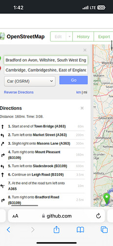
Is there a way to change the settings to miles instead of kilometers when looking up directions on openstreetmaps.org ? If not can openstreetmaps add this feature ? There’s many people in the United States that use osm so it would make alot of sense to have it included . I really hate google maps so would much rather use osm. Thank you please let me know !
Hi and welcome to the OSM community forum.
From past answers on the subject to see miles you’re basically dependent on 3rd party renditions, say for instance on your phone
Sorry
Why wouldn’t they just add it ? I’m sure it’s such a simple thing to do
There is no ‘they’ in OpenStreetMap.
The US adopted the metric system in the 1790s. As an American myself, I feel like we shouldn’t be catering to 200 year old machinists that stubbornly refuse to modernize.
Hi @2efred and welcome here!
Please be aware that the directions examples on the main page of OpenStreetMap are examples only!
These directions examples are calling external services and are limited to a simple A-B search, no via points and most important, settings are not accessible for users, that’s valid for a possible setting of “miles instead of kilometers” too. Please have a look at Web front end/Routing - OpenStreetMap Wiki and Routing on OpenStreetMap.org | OpenStreetMap Blog too.
There are a lot of routing engines using OpenStreetMap data, see Routing - OpenStreetMap Wiki
But for now: If you select the routing engine “GraphHopper”
you can follow the link to GraphHopper at the end of the list of directions
In the next step click on “Maps” item

Best if you bookmark the result ![]() and use it instead of the main page of OpenStreetMap.
and use it instead of the main page of OpenStreetMap.
Here you can access settings (and use via points too).
and change them to display distances in miles instead of kilometers …
not checked on what it got stuck
Omg how did that person change it ??? I would do anything in the world to have the option between km and miles
From reading the issue it seems like they offered a fix that didn’t translate well to all of the other locales around the world. The maintainers offered a steer as the best way to go, but contributions dried up at that point.
All (or almost all) the code that runs osm.org and related sites is written by volunteers. People can and do offer their own contributions (often to scratch an itch they may have). However, it’s important to have people deciding what fits well into the design of the site and what doesn’t, so that maintenance in future years is not an absolute nightmare.
Why is that that grasshopper can show miles but not osm.org ?
Seems like “everyone in a country agrees on which system of measurements the country uses” might qualify for one of those lists of “falsehoods programmers believe”.
Wait the website shows both km and miles ? Where ? i cannot find it !
The scale bars in the very bottom left of the slippy map on osm.org are in km and mi (or km and feet, or metres and feet when zoomed in)
There also appear to be “regional to a renderer” changes to units I’ve noticed (between metric and non-metric). For example, in California (USA, North America), Tracestack Topo layer shows contour lines in meters (“900 m”), but natural=peak elevations in feet (for example “2998 ft.”).
It litrerly used to be possible , I can’t understand why it can’t be possible again ? Please explain to me why they would get rid of such a simple option
I don’t think it was ever possible on the public website. That screenshot is from a proposed development that has never been included in the live website.
Also, while you describe it as “simple”, from a quick glance that proposed change required adding about 60 lines of code spread across separate Javascript, HTML, CSS and YAML files - so maybe not that simple.
it needs to happen ! I’ll do anything for miles to be added
Well then have a closer look on github and see what you can do
Please understand that OSM is practically a database, not an enduser product. And the osm.org website is mainly a platform to organize the collaborative works on that database.
There are myriads of apps, websites etc. out there that use and process OSM data and several ones of those may show directions w/ miles etc. Some examples have already been named above.
When you (?) posted that question yesterday elsewhere (seems to be deleted now?), I made a q&d example using leaflet-routing-machine (a third party library) to show miles instead of kilometers (and now, if you do a hard reload, for this US version feet instead of yards). This is just a raw and basic example but shows that you can easily build a website where you could use miles (and with some time and effort you could even build a nice looking one instead of this q&d example).
https://www.osmap.us/driving-directions/#13/40.7597/-73.9773
The UK version with miles and yards would look like this:
Thanks ! is there a way to do this and request it be added to the main website ?


