Is it OK to adjust cliffs to match USGS 3DEP?

I found that we can view USGS 3DEP data in the iD editor and I put instructions on the wiki: USGS 3D Elevation Program - OpenStreetMap Wiki

It shows cliff edges much better than satellite photos, which are often obscured by trees, offset/smeared because of the angle they were taken, etc.:


Before I go and adjust all the rock climbing areas, I just want to make sure:

  • It’s OK to trace this data because USGS is public domain, right?
  • This LIDAR data should always be more accurate than satellite images, right, so there should be no harm in adjusting cliffs to match the hillshade image?
  • Cliff ways should follow the top edge of the cliff, and not the bottom edge?
  • The part of the hillshade image that looks like the cliff edge is actually the cliff edge, right? The hillshade doesn’t mislead in some way?

Examples of what I would be doing:

Before:

After:

Before:

After:

5 Likes

If the data is PD, from your pictures these are beneficial edits, +1

2 Likes

In general LIDAR is high-quality but presumably there are places where it is misaligned/bogus/broken/inferior. So I would not assume that is better in every single case.

For example, LIDAR may be outdated and aerial more recent. Maybe some cliff was mapped based on survey. Though none of you examples suggest such case and in general such edits are a good idea.

And there could be places where it can be misinterpreted (for example in one case I confused stream with path on LIDAR).

4 Likes

Why would it be misaligned, though?

I do see that some places have inferior resolution, though :confused::

image

mistakes in alignment, different alignment criteria, software bugs in some layer between raw data and display in editor, manually applying wrong offset etc

1 Like

On that one, I’d also be realigning the track so it doesn’t go over the edge of the cliff! :grinning:

You mean Way: ‪White Markers‬ (‪242077587‬) | OpenStreetMap ? It looks like a scramble or hike at that point.

image

Sorry, I thought the quoted photo would have come through?

I meant “Section C - Tree Line to Basilisk” just below Sunrise cliff in this shot: https://community-cdn.openstreetmap.org/uploads/default/original/2X/d/d13df44039eeddc9c898129a7817741e78b2390b.png

Oh, you mean Way: ‪White Diamond Access Road‬ (‪679973414‬) | OpenStreetMap? Yeah, I need to verify things before modifying everything, though. I want to make sure boulders and trails are on the correct side of the cliff edges, etc. That trail runs below the cliff if I remember correctly. I guess there’s a way to offset satellite images so they line up with the LIDAR images?

I climbed there yesterday and recorded GPX tracks and took a bunch of notes, but still not 100% sure about some things. This area consists of a bunch of “tiers”, for instance:

(After climbing Dave’s Wall, I walked back down to ground level by finding large steps / scrambling down the tiers to the left, for instance.)

I guess the cliff way should be drawn along the top-most edge in most cases, but maybe not if there’s a tier that can easily be walked onto?

image

Yes, 3DEP is in the public domain as a work of the federal government.

To be fair, every other data source available to us has the same theoretical sources of error. The advantage of 3DEP is that it comes with rigorous documentation about standards and tolerances. I’m no expert in this field, but quality levels QL0–2 compare favorably to even high-resolution aerial imagery. The area around Minnewaska State Park, in the original post, is QL2.

According to WESM, the Rattlesnake Mountain site is right on the edge of a QL2 project boundary. The lower-resolution data isn’t derived from LiDAR; it might be from satellite imagery or IfSAR.

Several areas of the Northeast haven’t been covered by LiDAR projects yet:

3 Likes

Oh definitely, I am not saying that LIDAR is bad - high quality LIDAR is often extremely valuable, showing paths under permanent tree cover via extreme detailed terrain shape still feels like magic to me.

But it should not be assumed to be always correct and always ideally aligned and always up to date. And yes, this applies to all data sources.

1 Like

But how do we know which source to trust when they disagree? I can’t assume the 3DEP imagery is more accurate than the satellite?

USGS has a helpful instant chat and they sent me some links:

Horizontal Accuracy
It is difficult to quantitatively test the horizontal accuracy of the lidar source data from which most of the 1-meter DEM is produced. Factors such as Global Positioning System (GPS) accuracy, Inertial Measurement Unit (IMU) precision, flying height, and calibration control all affect positional accuracy (American Society for Photogrammetry and Remote Sensing, 2015). Because these factors differ across collections, the horizontal accuracy of the overall 1-meter DEM is variable. In most cases, the horizontal accuracy is expected to be within 1 meter.

Horizontal Accuracy
The horizontal accuracy varies by the horizontal accuracy of the source data. In most cases, the horizontal accuracy of seamless DEM coverage produced from 3DEP technologies is expected to be 1 meter or better (Gesch and others, 2014). DEMs created from lidar data and legacy topographic data are particular cases that require more explanation regarding their horizontal accuracy.
Lidar Source Data
It is difficult to quantitatively predict the horizontal accuracy of the lidar source data from which much of the seamless DEM datasets are produced. Factors such as Global Positioning System (GPS) accuracy, Inertial Measurement Unit (IMU) precision, flying height, and calibration control all affect positional accuracy (American Society for Photogrammetry and Remote Sensing, 2015). Although accuracy can be measured (as compared to predicted) through field collection, such a program is not currently practical.

1 Like

Again, depends on data sources. I am lucky to be from area where state-provided aerial imagery and LIDAR data has accuracy better than high-quality GPS.

But neither “LIDAR is always better aligned” nor “aerial imagery is always better aligned” will be always true. Though I would bet that LIDAR in general has better accuracy as whole point is getting extreme detail, so people making it will likely care more about calibration. While it is true for some aerial imagery but not all of it, some is quite coarse and not aligned with accuracy measured in centimeters.

1 Like

I also prioritize mapping the top edge of the cliff. I do map multiple tiers if they are reasonably distinct, like if the ledge separating them is a wide enough ledge to have it’s own trail. E.g. OpenStreetMap

1 Like

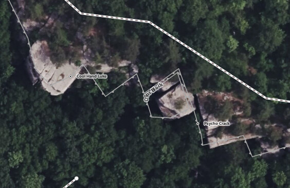
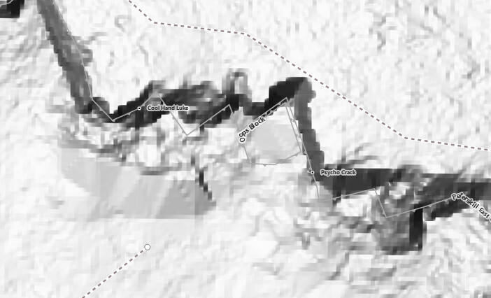
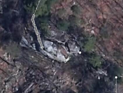
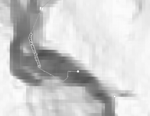
One flaw I’ve noticed is that the LIDAR processing seems to erase detached blocks (probably from whatever algorithm erases houses/trees to get just the ground elevation?):

image

So be careful of this if you’re also using this data.
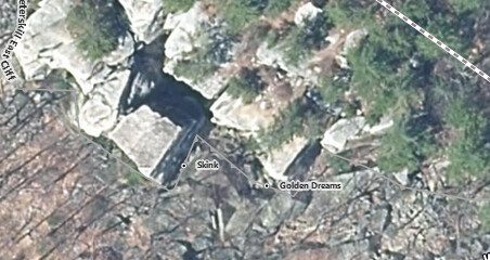
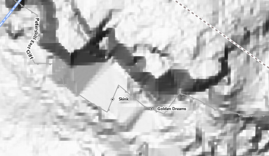
image
image

Another example:

image
image

Nice work!

I have also noticed detached blocks missing - for example Way: 1165276578 | OpenStreetMap

1 Like

We do not currently assess 3DEP lidar data for horizontal accuracy. It is difficult to have 3D ground checkpoints that would be visible in a lidar collection. For Quality Level 2 data, lidar pulses are nominally 0.71 meters apart so having a pulse exactly hit the 3D object would be unlikely. That is why our checkpoints are collected in flat areas so that the vertical elevation will be the same for several feet in all directions and the horizontal error will not impact the vertical assessment.

However, that being said, horizontal error in lidar derived elevation data is largely a function of positional error from the Global Navigation Satellite System (GNSS), altitude (angular orientation) error (as derived from the Inertial Navigation System (INS)), and the flying altitude. The GNSS and INS errors are not typically listed in the mapping reports so ASPRS developed a table that can be used as a guide to estimate the horizontal errors to be expected at various flying altitudes based on typical GNSS and INS errors. The flight altitude is listed in the mapping report. See the table below:

You can also refer to page 7 and page 18 in the ASPRS document here: https://www.asprs.org/wp-content/uploads/2015/01/ASPRS_Positional_Accuracy_Standards_Edition1_Version100_November2014.pdf

68 cm worst-case accuracy still seems better than satellite imagery, which is often skewed and offset by the camera angle, etc.

1 Like

This view has been added to iD Editor, but the regular hillshade, not the multidirectional hillshade. New Layer Request: USGS 3D Elevation Program · Issue #1490 · osmlab/editor-layer-index · GitHub