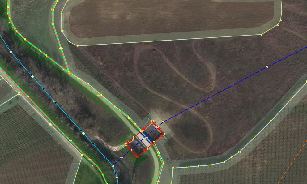
Fun with maps, cycled by many a time never knowing there’s on the other side of the brush, scrub and shubberies plus stream (labelled ‘river’ Foro) an overflow area. There were in the last decade sluice gates and an area set aside in a flattish zone (8.379ha per the measurement plugin), sluice in, sluice out, bridges across and the big area to hold water while it’s barreling down the hills and all knowing the ‘river’ can’t take all that input. The flood plain is agriculturally employed still and in winter times used as a motocross pitch.
Chose to map the sluice gates as area, tag it for now as canal for lack of hydrological knowledge of the right label (an entirely artificial ‘waterway’))and mapped intermittent, seeing one of the discussion participants tagging rivers and streams through a lake with layer=-1. While ID is happy with that, JOSM balks at this combination moaning a long waterway being below the surface without a tunnel type of tag, but that’s in testing because it’s not through a waterbody, rather a meadow.
Based on your description, you are mapping an alternate overflow “river”. That sounds pretty reasonable especiallysince you’re adding the associated flood control measures. I would suggest removing the layer=-1 as the water is not below ground. Instead use the intermittent=overflow tags to make it clear that the water is only present during overflow conditions.
Leider, intermittent=overflow is not in the TagInfo vocabulary. Did find a 1.2K use of flood:overlow=yes with combination of other flood type such as flood_prone but has no descriptive text. The land area I had tagged flood_prone=yes and saw a puddle that had a type of river bedding like pebble cover i.e. nature used it before, man decided to give it another function which came with a price.
Checked around and was surprised to see that the found floodplains still having the name of being a floodplain do not carry any flood related tagging, just grass. Can’t say work is gonna be done, ever.
This is area doesn’t automatically fill up during a flood. It was purpose to only fill up because of man made conditions. Meaning that local officials can control if and how much water enters the man-made river. Making the river intermittent nature based on flood overflow policy.
The need for a separate thread was brought to my attention by a community member. I moved these posts to their own dedicated thread because I agreed the posts are very tangential to the content of the original topic. The title was suggested to me. If the participants have a better idea for the name of this thread, I am happy to change it.
You seem to have hit the jackpot… further on, there is basin=detention:
A special basin used for detention of rainwater before being discharged into a surface water body. The basin is normally not filled with water. There should be an inflow and an outflow.