demanding_alpine_hiking four mountain_hiking, wrongness probably (I do not know why people choose those values) due to steepnes. Never heard of such a Volvo car, I am happily almost oblivious about that abominable invention:-D.
Another source of confusion can be official designation. In Argentina, they use colours I think three or four, but the main distinction seems to be length and elevation difference, all the trails overed by it were mostly hikin or mountain_hiking. Somebody might have try to do 1 : 1 mapping to sac_scale, when at least two of their grades corresponded with one sac_scale grade.
I also think, the column “Equivalent SAC scale based on Swiss Alpine Club” should be removed from the fine article. Especially, if openstreetmap wants to emancipate. Any takers? I am tired of sentences like “But on hikr.org Großglockner is a T2”.
Well, there is still the mention that in Switzerland and that part of Austria where it is officially used, it should actualyl adhere to the official grades.
Then let’s start to remove that: OSM is global, if a local community wants to have local definitions, they can specify it elsewhere. And in the present case, that’s almost stating the obvious and except for a handful of cases it will robably makes little harm.
I think this is ok. I would probably tend to put demanding_mountain_hiking because there is no exposure (and to anyone having sticks or even a branch, which I do not count as using hands, hands would not be necessary), but I can live with your classification too. Definitely not hiking or below!
It’s clearly described in the wiki, that exposure is also a criteria for sac_scale. It is the combination of exposure and technical demands that make a trail “difficult”. And that is exactly what sac scale wants to describe.
I would rate this route as T2 or T3 at most, it’s not a route in the sense of alpine hiking. Alpine hiking requires basic climbing skills and falls can be potentially fatal, that doesn’t seem to be the case here.
EDIT: But you could make a poll?
Why should we remove it? It is just an abbreviation, also used by a lot of renderers like Tracestack. And also the relationship to the official sac_scale is already well described in the wiki.
This question is NP hard, in engineering speak. I have seen similar pictures on the SWW website for trails ranked T1 (SAC grading). No idea, who does the grading there, I guess not the people from the SAC working group tasked with grading their own trails. I certainly would not grade that “hiking”.
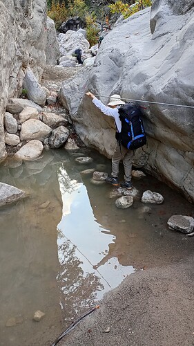
If you had asked me in advance, I would have told you: The photo does not show hands for advance but hands for balance. So demanding_mountain_hiking perhaps in order. But the only hazard is wet feet, so simply mountain_hiking in order too. Remember, several facets come to play when grading to sac_scale.
Yes, the relationship is that sac_scale is an off-spring of the Mountain Hiking Scale developped by the SAC (to grade the ways leading to their huts.)
The OSM version in the beginning was written in unintelligible Denglish and since then polished by nice English natives with knowledge of what mountain hiking is about. The SAC version meanwhile also was translated to Denglish. They refer to demanding_alpine_hiking as difficult alpine hiking.
Even though you made some changes to the openstreetmap documentation of Key sac_scale that push it closer to recent editions of the SAC scale, I do not see much value in keeping that cruft. There is no 1:1 mapping any more.
PS: I am still wondering what the strolling value will bring: Will it make hiking harder?
It makes sense to continue to orientate to the original scale and ratings outside of OSM, even if some people on hikr.org don’t understand the scale, it is sometimes a very valuable resource.
Though the scale has been tweaked slightly, I don’t think any further emancipation makes sense. It’s a mature and established method of rating hiking paths, I don’t think we need to reinvent the wheel.
As a compromise between removing it and leaving it as it is:
I imagine it would be helpful for people not familiar with the real SAC scale to have a table that shows the rough equivalents of sac_scale= values in other rating systems e.g. Yosemite Decimal System. That table could also include the Swiss Alpine Club scale with values T1-T6?
In defence of T1-T6, it has some advantages as a shorthand. I imagine this is why it is used in the Tracestrack Topo layer. Calling a path T2 on a scale from T1 to T6 also means you don’t have to explain that something can be =mountain_hiking even if it’s nowhere near a mountain.
But what about trails that are technically demanding but without exposure?
I differentiate between the two by assuming “hands for balance” means just touching something for balance, and “hands for advance” means you have to firmly hold something to advance. Here you have to firmly hold the safety rope to proceed without falling (the next stepping stone my wife is going to step on is wobbly, and the one after that is under water).
The original SAC scale as used by SAC combines technical difficulty, trail visibility, exposure and steepness. However, though often correlated, there are quite a few trails where not all combine to make a difficult trail. We already separated out trail_visibility, while we can also easily separate out steepness (we already have the incline tag for it, and it can be seen on maps with contour lines) so only technical difficulty and exposure remain in sac_scale.
We need to discuss how to tag trails that are technically demanding without much exposure, and easy trails that do have dangerous exposure. I would tag the first group with the sac_scale value that expresses that difficulty, and would tag the second one as an easy sac_scale value + a description of the danger (in the form of a hazard tag if there is one that is appropriate). I.e. sac_scale should primarily describe technical difficulty.
I think the assumption is that you need to use your hand to lift yourself up a bit to qualify. Personally I can also imagine going through that stretch sideways and leaning on my hands on the rock if the rope was not there, then it would be for balance. Frankly I think you are disecting it maybe a bit too much, the good thing about SAC scale is that it is one value that tells me how trail is difficult. Having five separate tags is nice in theory but in practice it would get vevry inconsistent coverage I think. Visibility is something that can be quite independend of difficulty if markings are present, but already putting the two for trails is a bit of a hassle. Please do not make it five (especially when incline is given by contour lines)
And also the main thing - you can also just walk through the puddle in your shoes or barefoot to advance, so after thinking alpine_hiking really feels too much. ford=stepping_stones and safety_rope=yes/5 seems in order. It looks like tha path follows a dryish riverbad. That would usually deserve (demanding)_mountain_hiking.
I think we agree: hiking_exposure=* was proposed but I think it would be too bothersome to tag with so many tags, and won’t help with getting these quality tags used by data consumers.
The trail is indeed going through a mostly dry river bed: it has other parts where you have to climb on top of big boulders using your knee first, so I’ll keep it sac_scale=alpine_hiking for that part and reduce the ford part to demanding_mountain_hiking. I already added safety_rope=yes and will change the ford to stepping_stones
Well, T2 already requires surefootedness, which covers a lot in my opinion. If, despite the lack of exposure, climbing with physical effort is really necessary to a large extent (i.e. UIAA II), you could also consider going to T4 or above.
The sac scale is so elegant because it can be applied qualitatively
I think the Wiki describes the concept of climbing, UIAA I and II, surefootedness etc. quite well now, or should we describe it even better? Maybe we could add the difference between hands for advance and hands for balance?
only now I see @Road_Runner requested a poll. I will gladly start one, but only if @rhhs will upload the picture onto OSM wiki so that it can later be used on the wiki page.
While discussing sac_scale in general (ad nauseam?) is certainly worth it, one should pay attention of the particular thread where to do it.
Don’t feed the (s)troll.