I added an islet with trees on it. Only the trees show up. How can I fix it?

Half a year ago, I added an islet to OpenStreetMap. It’s here: 60.05398 10.68283.

The tags are:
natural = wood
place = islet

However, when I look for this island on openstreetmap.org, the trees look like to be in the water, not on an Island:

Why is this happening, and how can I fix it?

1 Like

With a lake, make it inner to that object. At sea has another solution

1 Like

What does making it inner mean? Or, more precisely: how can I do it in browswer? (I am using the editor directly on openstreetmap.org.)

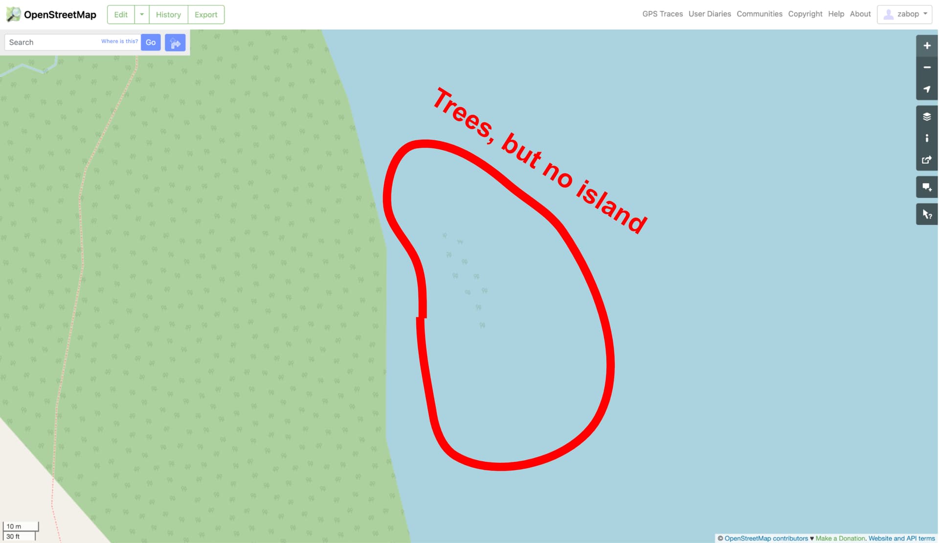
Suppose this lake is a polygon and the islet is. In ID editor select both outlines, right click and the pop up menu should show a plus (+) sign. Hit that. That will add the islet as being an inside member of the lake. It should then show a blue-ish rim outward.

4 Likes

I hope I made it… Not entirely sure, but I think I did.
(Changeset: 134548282 | OpenStreetMap)

How would I verify whether my edit achieved what I wanted it to achieve? ie if islet is now inner the lake.

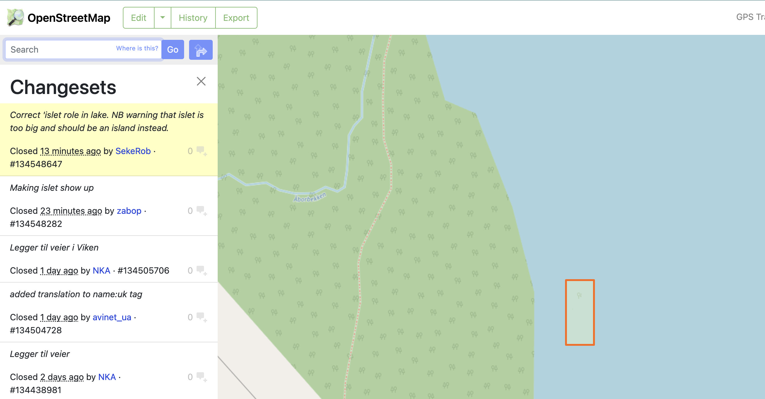
You made it inner OK, but to the wrong bit, the wood, so now it has a greenish outer rim instead. I downloaded the data and see the lake already has multiple inner areas which can help you see the relation. of the islands and such. Done the dirty deed for you. Just draw a new islet and try again, but dont save. Just test.

The JOSM editor validation says it’s too big for an islet and should be tagged as an island.

I think I was successful now. I did click Save, but I put the checkbox for review by others before application.
Now it says:


It is looping through these conflict checks, it doesn’t seem to finish.

I just clicked “Back”, I don’t think my changes were applied. I see you have edited it, so I assume it’s good now. Thank you!

The conflict was caused by me, sorry. You were working with old data whilst I corrected the islet and saved. When adding something inside a bigger area to make it ‘inner’, one has to make sure the right ‘outer’ object is selected. The highlighted outline should aim toward the inside object. If it points away you’ve got the wrong one. In ID that selection is rather quirky. In JOSM it’s a mouse wheel click and selection from a list of objects that share sides.

The question open is if it’s and islet or an island as JOSM was proposing.

No problem, thanks for helping. Hmmm, good question, I think the description here: Tag:place=islet - OpenStreetMap Wiki describes the situation more accurately than the one here: Tag:place=island - OpenStreetMap Wiki.

But I’m happy with both :slight_smile:

1 Like

By the ‘islet’ measure of 1 km square, does not look like that to me… islet has my vote.

So we agree, yes? I also think islet is better :slight_smile:

The lake is still duplicated as an islet, I think that was what the warning was about: Relation: 15687044 | OpenStreetMap

1 Like

Well spotted, duly removed the 1 member relation.

The ‘islet’ now shows picture perfect.

Have a good day.

1 Like