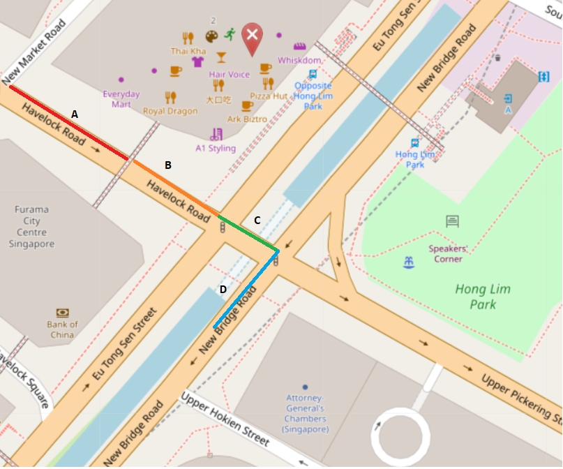
Way A has traffic “turn:lanes”=>“left|left;through|through|through|through;right|right”
Way B has traffic “turn:lanes”=>“left|left;through|through|through|through;right|right”
Way C and D do not have turn:lanes.
How to determine that the last lane of B Way also connects to D? Because there is no relation between B and D and C doesn’t have any turn:lanes information. I also looked at relations like route and connectivity from pbf file but didn’t find anything. If I want to have lane connectivity of this intersection then how can I do it?
According to Bing Maps - Directions, trip planning, traffic cameras & more there are no dedicated turning-lanes on way C. So technically all lanes from C connect to D. I don’t know if making a right turn from the leftmost lane on way C into D would be legal in Singapore.
If I am coming from road A and want to turn right then it’s a valid turn as per satellite imagery so then how the lane connectivity should be created based on existing data?
There don’t seem to be connectivity-relations present in this specific location. I tried to read the data from osmium library. Is there another way to read connectivity-relations? Can you please verify if connectivity-relations are present there?
I wasn’t saying that this specific crossing has a connectivity-relation. Only that in a lot of cases, you will have to add one if you want to be able to reliably determine which lane goes where.
Is it viable to check if routes are present from B to D and then create connectivity?
I am checking the osm data using josm and I see that there isn’t any connectivity relation defined but there is a route described which goes from A->B->C->D. Considering the route I could create a lane connectivity rather than relying on turn:lanes only?
Any thoughts? Sorry but I have little or no prior knowledge of how to read osm data effectively.