I don’t think it’s very important to list all possibilities, the main point is that they should not be connected to nothing at either of their ends, in almost all cases.
You’d have to dig through the source code for iD, the code for disconnected ways currently is here, but one thing I’d consider is that the tags marking the end of a power line should also include any tags we’d expect on a power line with a transformer on them, or any tags for when a power line moves from above ground to underground.
I’d have to agree, it’s not as simple as fixing an isolated highway, those are usually pretty obvious whether it’s a problem or whether you’ve actually mapped all you can and are able to ignore it.
Plus, power lines can abrubtly end but still be valid, and you’d need to rely on the right tags and likely a survey or street level imagery to confirm/validate that.
It’ll still go somewhere, but if that somewhere is underground, you’re not necessarily going to be able to see that from aerial imagery, or continue to map that without either surveys or a data source with that information.
There’s good arguments either way, it’s one I’d at least want to discuss with the community/developers about. Some people may just be adding poles as they see them but might not be able to link them all up.
What might not be a bad idea is looking at whether there’s any standalone QA tools for power infrastructure, I feel like the iD warnings should be something any mapper can resolve, whereas a more specific tool will be helpful for those who have more interest and knowledge in it.
I’ve ended up adding runs of power poles that terminate abruptly even when I know that they don’t in reality because the aerial imagery either runs out or I was relying on the shadows of the poles to spot them in the imagery and there’s a change to the vegetation or environment that makes the shadows harder to spot.
I think a warning here might just end up encouraging mappers to guess where it goes and I don’t think that is particularly helpful.
I completely second the need to have more warning in iD about power lines, as a significant amount of error we are continuously fixing come from this editor.
Osmose currently measure this and detects worldwide:
226.5k warnings on power transmission lines and cables
854k warnings on power distribution lines
Power lines can go underground or terminate at some point but this will always need appropriate tags like line_management=transition, power=terminal or line_management=termination to be valid. So a power line stopping on a simple power=tower without any further tag should be completed.
They don’t need warnings to do so but it also could encourage people to seek for proper data to solve the issue. The warning could be framed to not encourage to guess without knowledge.
Another PR has been made to warn about power lines connecting to highways or waterways, another missing validator we miss in iD.
Those two could really improve power line mapping in OSM.
The biggest problem is that the information required to solve those warnings isn’t always obvious from aerial imagery, compared to things like roads and paths. For something like iD, there needs to be a balance between “we want to prompt someone to finish mapping this” and accidentally making newer mappers think they need to do something to solve a warning, because that’s exactly what happens with those warnings.
The best place for something like this is an external QA tool in my opinion. If you’re interested, you can go there and find problems to fix.
We shouldn’t confuse necessary UX to guide mappers in the right direction to find knowledge if possible and detect such problems, whatever message is delivered on the frontend.
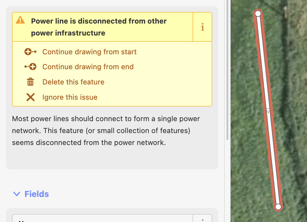
What you’ve mentioned there isn’t what this thread was about. What you’ve mentioned is 100% valid and I’d back that being put into iD. This thread was about disconnected power lines and continuing them, in the same way that iD already warns about for disconnected highways.
Yes and it’s also what we are cleaning, by setting tags on the edges or continuing lines. It’s even worse on this point as it only increases along years.
