In remote regions of South East Asia, many settlements are connected by long dirt tracks, often stretching over 10 km. These are typically tagged as: highway=tertiary/unclassified + smoothness=very_bad/horrible + surface=unpaved/dirt/compacted.
As time goes on, parts of these roads get paved in sections. Eventually, some become fully paved and are suitable for standard vehicles, tagged as: highway=tertiary/unclassified + smoothness=excellent/good/intermediate + surface=paved/asphalt/concrete.
During the transition, these roads are usually accessible only to high-clearance vehicles. For outdoor enthusiasts like 4WD drivers or adventure motorcyclists, it’s helpful to know whether a road is fully, mostly, or partially unpaved. For instance, they might prefer a route that’s exclusively or mostly unpaved over one that’s largely or fully paved.
But what if you don’t have the exact locations of the paved and unpaved sections? How can we tag these roads to reflect their mixed nature and make this info useful for renderers?
Could surface=mixed work?
This tag isn’t widely used but does describe the concept of a road with varying surfaces. However, it doesn’t distinguish between roads that are mostly unpaved versus mostly paved, which is a key piece of information.
Should the surface tag be removed?
If the surface isn’t exactly known, should it be left out entirely? The problem is that “unknown” is very different from knowing that 20% or 80% of a road is paved.
What about smoothness=very_bad + surface=paved for mostly paved roads?
While this isn’t technically accurate (since the paved sections are often in good condition), it could imply a (mostly paved road that’s still only suitable for high-clearance vehicles.
Combine tracktype=grade1/grade2?
This could be another option, but it’s tricky to apply. By definition, grade1 must be paved, and grade2 must be unpaved, so it could conflict with how these tags are defined.
Example of alternating paved (blue) and unpaved (green) sections when exact locations are known. Since maintaining such detailed information isn’t practical for most mappers, a simpler alternative tagging approach is needed:
I’d say the best way to tag such roads is to separate the sections of course. If the sections are not known at all, how would you know the share of paved/unpaved each?
An approach could be to try to map a rough estimation of the sections and add a fixme-tag asking for further refinement. Although not precise, still better than just tagging “mixed” or the like imo.
Tagging “mixed” surface is a poor option as this does not give any clue about the mixture itself. If I would not want to map estimated sections I would go for something like:
Removing the surface tag completely would be the poorest solution.
Based on trip reports from other users, “the road from village A to B is now XX% paved.”
From personal experience, when I didn’t capture images of the exact start/end points of each section. Old satellite imagery isn’t helping either, and there could be many such sections!
Sure, if the road is split into countless patches changing surface, it means a lot of survey and work to tag this accordingly. In such cases the best you could do imho would be tagging it as kinda surface=paved;unpaved or the like. Anyhow this makes it difficult again to add an overall fitting smoothness=* value. What I could imagine is to add a short description giving more details.
Another problem may arise due to erosion of the paved sections. I know such roads from central African countries and specially those small rural connection roads are often paved in very poor quality so the asphalt or chipseal surface quickly starts eroding and in many cases the result may be even worse than a properly serviced unsealed road. So keeping record of that may be difficult and time consuming.
It is a tricky problem with no obviously good answers.
no, it does not give no info whatsoever
is it mix of mud and dirt ? Is it mix of asphalt and paving_stones ? Is it mix of paved and unpaved ?
It provides no info whatsoever. Even surface=paved;unpaved is better.
Do you know at least approximate info such as “starting from village A there is a paved section, but more or less in the middle to B it reverts to unpaved”
In such case I would tag first 1/3 as paved, then 1/3 without surface tag, then 1/3 as unpaved (or even better, giving more specific values than just pavedunpaved)
but if you have only “part between A and B is paved part is not” then it is sadly not doable
that does not seem a great idea as may mislead people into thinking that road was mapped as paved. This does not seem a great idea.
ideally, get detail so it can be mapped
but I know that it is far from easy
but mapping untrue info does not seem greater either and surface=mixed is basically the same as no surface info at all while being confusing to other mappers.
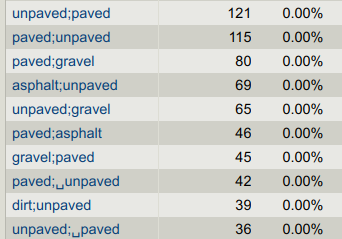
Just one caveat - those sorts of values on ways aren’t usually assigned deliberately. For example, searching for “unpaved;paved” finds this, which was the result of a “way merge” 9 years ago. The mapper either wasn’t warned about that or ignored the warning.
However, something like unpaved;gravel might have been set deliberately.
I also think the only proper way to map it is to survey it and map each section of paved/unpaved road separately (using a mapping app like StreetComplete, for instance). I wouldn’t map a few meters of paved road in an otherwise unpaved section, but I don’t think it is a problem to cut the road in as many sections as necessary.
If I had a general idea where some of the longer paved sections were I’d probably split the way and tag some sections as surface=paved and others as surface=unpaved along with note=Surface extent is approximate and could use improvement..
If I had no idea where the paved sections were but I knew they were the minority of the road length, I would tag the whole thing as surface=unpaved along with note=This road has some paved sections but the majority is unpaved. Improved detail from a better source is welcome.
Obviously splitting the road exactly where the surface changes is ideal but this is what I would do if lacking that information.
If you really can’t split it yet, or it really alternates too much, =paved;unpaved would be the best to start with. I would hope the quality implication and expectation on standard of =paved calls for it to be some super majority, not merely a little more than half.
On percentages, the tens of surface:paved= could be adapted with =partial , =limited , etc. In fact, surface:paved= was in the historical origin surface= , with some differences. Proposal:Surface unification - OpenStreetMap Wiki
If the section is being actively worked on or planned, construction:surface=paved or proposed:surface=paved can give some context. With check_date= too to update them in the future.
Thanks for the suggestion of StreetComplete, I’ll explore that more for future use.
Is there any guidance for the appropriate/inappropriate highway=* classifications for these type of regional roads with varying surface & smoothness conditions or it isn’t a factor at all for OSM purposes? eg, would the scenario from the OP apply just as easily to primary and secondary roads or that would typically indicate a problem with the OSM classification?
Also looking for guidance regarding the impacts of seasonal weather conditions on unsealed/gravel rural/alpine roads in regional VIC/NSW, AU?
Does the OSM community expect semi-annual or seasonal updates to the road condition by different road user types say in the wet/winter months by winter sports users when unsealed roads are softer and get notably worse for wear and become unsuitable for 2WD and other unmodified street legal cars) only to be reset 6 months later in the warm/dry summertime by other drives who attend other areas for off-roading/camping experiences for their annual excursion through the area?
Not really, no, as you don’t know how long it’ll take for the various routers to update their data?
The best we can do is tag the road surface (unpaved) & leave it for drivers to think “There’s been heavy snow / it’s been raining for a week, so that dirt road is probably impassable”
In principle it could apply, as the classification broadly reflects importance in the road network, and an important road could have changing surfaces in some regions.
Note that the original question relates to a situation where it is practically difficult for mappers to survey these roads. Generally primary and seconday roads are the first to be surveyed, and by definition there won’t be very many of them, so it’s probably more likely in that case that mappers can tag the individual segments.
No, as @Fizzie-DWG explained. You can tag them with tracktype=*: if it’s mostly soft clay that becomes a mudbath in the wet season, it’s tracktype=grade5, if it’s quite firm and passable even in the wet season, it’s tracktype=grade2 (unless it’s paved then it’s grade1)
This is what I usually do, though I’ve noticed that notes don’t give much of a visual clue for end-users or mappers to improve it. Only a few apps, like OsmAnd, have options to display notes or fixme tags. I’ve also gotten feedback in the past like, “Hey, that route isn’t off-road anymore; there are lots of paved sections now.” When I ask which sections, the reply is often, “Oh, I can’t remember.”
I’m curious if using surface=paved;unpaved for mostly paved roads and surface=unpaved;paved for mostly unpaved ones could work as a temporary solution, especially for newer mappers. I’ll test this approach with OsmAnd and see how it behaves.
In Thailand, all trunk, primary, and secondary roads are paved. However, in less developed countries like Nepal, Laos, or Madagascar, some of these roads might only be passable with a 4WD. While road conditions can sometimes influence their classification, it doesn’t change their importance.
for example in Poland surface=mud highway=primary is indicating serious tagging issues while in Laos or Siberia this may be perfectly valid tagging.
It is factor in OSM tagging in the sense that highway=trunk/primary etc is for the roads according to importance, and more important roads are more likely to be well maintained.
What it means depends on region. In some places secondary will be dual carriageway with multiple lanes, in some regions secondary will be road less likely to have fallen trees blocking it (compared to alternatives), but you still should carry chainsaw just in case.
So in some areas say primarysecondarytertiary are likely paved, in contrast to less important roads. In some even highway=track may be paved, in some even highway=trunk may be unpaved.
To add to this, even if you just tag “the bits that you know are paved” as paved and “the bits that you know are unpaved” as unpaved (and left the rest) anything that avoided any unpaved roads would (correctly) avoid this one.