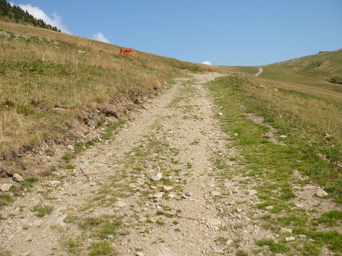
I’m with you on almost everything & I’m mostly with you on this. I definitely don’t think we should be micromapping roads, but if something is tagged very_bad or horrible (high clearance or 4wd) and a user see the beginning of the road as pretty good they might conclude the tagging is wrong and venture forth. If there’s a half mile of bad road in middle of the good road, and it’s rendered appropriately one can make a more informed decision. I do this rarely, but here’s an example of a short 4wd (horrible) section in an otherwise high clearance (very_bad) road: Poncha Creek Road
Well; if anything, I’d say such results would indicate that such picture should be removed, as if people tag according only to that picture, the inferred meaning would be wrong in 40% of the cases, so it is obviously not a very good picture if this sample of users is any representation of reality (that is, the situation/tagging it associates has ambiguous meanings).
Another issue is that changing what the EXACTLY SAME PICTURE means today compared to what it meant yesterday is horrible UX, guaranteed to produce much more misery than it could ever hope to solve.
In addition to creating obvious huge amount of confusion, changing what the people though some tag meant would invalidate many of pre-existing “bad” and all future “intermediate” uses of that tag of people, making those two values in combination with surface=paving_stones unusable for all future (unless it was accompanied with mechanical edits removing all such values from the map first and preferably contacting the editors who used that in the past about the new meaning)
So, IMHO - either keep the status quo (thus at least not disturbing how it is is used and thus making all existing “bad” and all future “intermediate” problematic), or (better, but much more work) completely remove that picture by replacing it with something else (preferably something that creates less confusion, e.g. whose size is more likely to be correctly interpreted how big and deep the gaps are in reality, so there is [hopefully significantly] more than 60% of the users which agrees what it actually represents - probably best procedure would be taking several pictures and putting them to vote to find best candidate, and then checking in another vote whether it produces better results then current 60% match).
Note: One should also take into important consideration that the few dozen people who read this thread and vote are actually insignificant minority compared to number of people who mapped that tag (many of whom has looked at the wiki in the past, or used solution like StreetComplete which had etc.)
So while voting here could be very valuable input to creating new tags/values, for already widely used tags it is much less so - as 99% of the old people will continue using in the ways they’ve already learnt to do in the past. As in practice, only new mapper (who never used that tag before), and few dozen participants in this thread (insignificant) would actually use the new meaning. And all the users who would like to use the values, would have to use at history modification dates and guess is it more likely that users meant old meaning or new meaning?
I suspect that many of the
badvoters are cyclists? I agree that this (rather unusual, I think) surface is particularly uncomfortable for cyclists, so maybe if this is the surface of ahighway=cycleway, it should be taggedsmoothness=bad?
I think that smoothness should be kept as being useful to the most sensitive vehicle that still can still use that surface, as it means the most difference there.
For example:
- if you drive SUV, you don’t really care very much whether it is
goodorexcellentsmoothness of thatsurface=asphalt. But if you use roller blades, you do care. So the difference betweengoodandexcellentshould be based primarily on rollerblade users, not SUV users (or other less sensitive vehicles). - Same for other values, e.g.
intermediatevsbadis mostly interesting to about trekking-class bicycle users - it is not interesting for e.g. rollerblade users (as they can’t really use that surface anyway), and it is not really interesting to e.g. tractor users (as it doesn’t make a difference in their lives at all). While SUV is somewhat affected there, that effect is much less then the effect for trekking bicycle user; so in that specific example trekking bicycle user should be the one for whom the difference between that two smoothness values is primarily focused on (as they are about the most sensitive to that specific difference).
Or should a subtag
bicycle:smoothness=*be introduced to handle such exceptions?
To play devil’s advocate; why not invent motorcar:smoothness=* instead and keep smoothness=* bicycle-related? Afterall, there are likely more bicycles in the world than cars ![]() . But, jesting aside, I don’t think that would be good idea in either case, because:
. But, jesting aside, I don’t think that would be good idea in either case, because:
- firstly,
bicycle:*(ormotorcar:*) as a prefix to*:smoothnesswouldn’t help much. There is as much difference between downhill MTB bicycle and a road racing bicycle, as there is between sports car motor vehicle and an ATV motor vehicle. So It would make as much sense as conflating “sports_car” and “ATV” and “tank” into single categorymotor_vehicle:smoothness– i.e. not any sense at all, really) - secondly, I don’t think trying to chop it down into dozens of subtags (and it would have to go that way if it made sense - e.g.
sports_car:smoothness,suv:smoothness,atv:smoothness,mtb:smoothness,city_bike:smoothness,road_bike:smoothness,tank:smoothness…) would do any good, really. It would make complex situation even more complex, harder to tag, harder to user, and overall less likely to be useful, and all that without really solving any issue.
7 Likes
It’s highly dependant on the situation. The main issue for my situations is if that if you don’t have smoothness tagged, you may NOT assume equal quality as you seem to imply above (it might be the same, or better, or - quite often - worse).
I mean, if I knew with certainty it had equal quality, I might as well tag that smoothness, eh? It’s two clicks on the phone in StreetComplete…
So, if I didn’t know the smoothness quality of the the shorter (untagged) route, it depends what I’d do:
-
for myself alone on leisurely ride, regardless of route length, I’ll most often prefer the one without mapped
smoothness, even if that smoothness is excellent - because I get to get there and mapsmoothnessin SCEE / StreetComplete for future use (mine and all other OSM users). Also, it means I haven’t been there yet, so for me it is a plus in itself! -
if I’m leading a group which include at least one road bicycle, I’d definitely choose one with mapped
smoothness=excellentand not the one without tagged smoothness, regardless of the length (as to improve group happiness - even if it is risking just one person having to walk just hundred meters in SPD shoes carrying their bike in hands. IME, people seem to like other people trying their best to make the ride enjoyable for everyone, even/especially if they’re in minority) -
better smoothness does not always equal more preferable. For example, over here if two mostly comparable roads go same places, it is quite likely that the one with worse surface quality will have significantly less cars (and have them moving at slower speeds). So, even when both smoothnesses are known, if you (or your group) prefers quieter roads, and their bicycles are fine with that, they might (perhaps somewhat unexpectedly) intentionally choose
intermediateover theexcellentone. -
if I’m leading a group who are all ready for some offroad, depending on the how long we’ve been riding I might try to sneak in that first option in order to get a chance to map some more (e.g. if they’re fresh and full of energy and not sore), or I might put it to vote (“ok, road (a) is longest at 20km, but known good asphalt but also higher car traffic; road (b) is 13km probably asphalt or compacted of unknown but likely lower quality, but car traffic should be much less too; and option (c) is this only 4km long track shortcut through forest but with known bad smoothness ground, which might be still muddy from yesterday rain. What say you?”). And I’ve had groups (even ones of same people with same bicycles!) choose different options at different times, depending on the myriad of factors.
So, I think any router trying to make one-cycling-router-preset-fits-all is doomed to fail (in many use cases). It all depends on very specific circumstances. At least for majority of my rides. YMMV, of course - someone elses rides might be monothonic and deterministic to a fault, or anywhere in between.
Even for same bicycle types (e.g. several routers distinguish MTB vs road bicycle etc.) one user might prefer quite different route from another user with same bicycle type. Sometimes vastly different. smoothness adds a valuable data point allowing people those choices.
e.g. many people get on the bikes not for commuting purposes where e.g. shortest or fastest route might win (even there, some might prefer other factors like safety or variety or being removed as much as possible from car noise/stink much more then they care about mere speed or low mileage), but for many other reasons too.
E.g. many who cycle for recreation do not even want to get from A to B in shortest number of kilometers or in fastest time possible; they might just want to get from A back to A in longest number of kilometers that they can ride which will put them through most amount of nature and least amount of car noise and smells and road stress and repetition, for example. That would be me most of the time, for example ![]()
Or they might want most technically demanding one as they like pushing their limits.
Or they might want one where they get best speeds on their cyclocomputers, or longest or steepest downhills, or whatever.
There are likely more different cycling preferences then there are cyclists, really ![]()
3 Likes
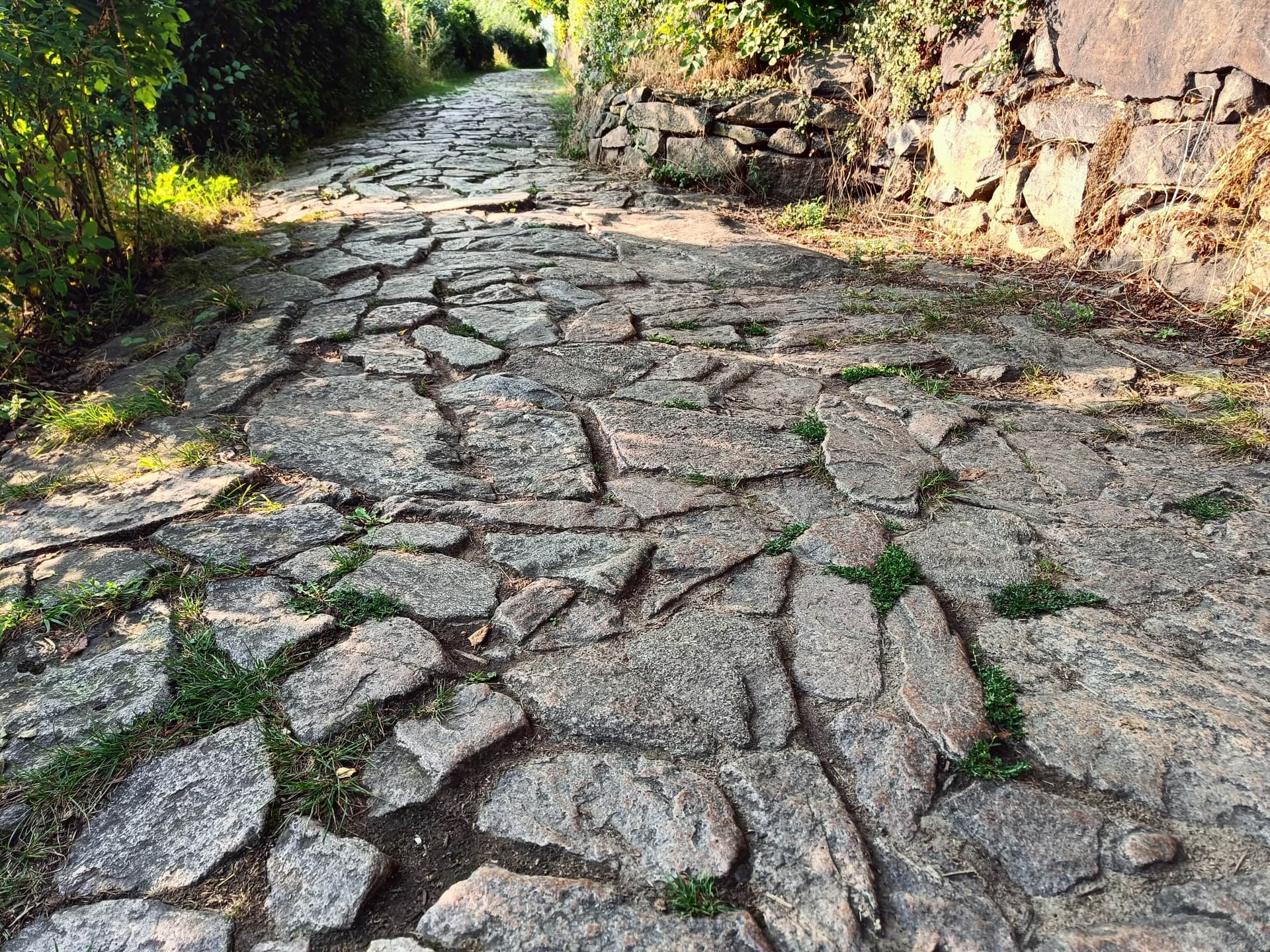
I think it would be good to preserve the picture and what we have learnt from it, by adding a caption that summarises what we think about it. For this particular one, we could move it to the intermediate column with a caption like “This picture was put up for a vote, where 26 voted for intermediate and 13 for bad. The surface was believed to have worse smoothness for vehicles with narrow tires (bicycles) than for vehicles with broad tires (cars). It was difficult to see how wide the gaps between the paving stones are.” It would be ideal if all pictures in the gallery had such captions…
I agree with you when it is about the meaning of tag values: there should be a very very good reason to change one, with good agreement that it’s really necessary. But this is about a single picture that doesn’t illustrate the tag value as well as others. If there is a significant disagreement between different pictures supposed to illustrate the same tag value, something should be done about it, better sooner than later.
We can only hope that they are a statistically significant representation of all mappers. I don’t think there’s a better way to find the opinion of all mappers.
I agree; I think this is the original idea behind evaluation smoothness. However, in practice it would mean that a mapper should have experience in using at least 7 different vehicles… I think this is not realistic.
I realised from your comment that I don’t have experience in using roller skates or skateboards, which means I can’t really evaluate the difference between excellent and good. Instead, I fall back on visual evaluation of the surface (which I have been arguing against, but now I realise I’m doing it myself).
I think we could make a subtag for single track vs. two-tracked vehicles for those who want to go into such detail, but not beyond that. There is a difference between your city bike and mine, and even between my SUV with inflated tires and with soft tires ![]() We should not go down the road of more and more detail, because most mappers would not be able to follow and stop mapping it at all. I like it that
We should not go down the road of more and more detail, because most mappers would not be able to follow and stop mapping it at all. I like it that smoothness is trying to categorise surface quality for several map users at once: this usually works, but not always, and most of the cases where it doesn’t work seem to be because of the different width of the vehicles.
I admire your striving for perfection ![]() Maybe it would be even better if the router app could also read your thoughts, sense your mood and take into account how well you slept last night, and recommend the perfect route
Maybe it would be even better if the router app could also read your thoughts, sense your mood and take into account how well you slept last night, and recommend the perfect route ![]()
I think the best we can hope for is a router that’s not just car-oriented, and that takes smoothness into account when evaluating 2 alternative routes that both have it tagged (increasingly common in the future, I hope) and tells you that one will be a rougher ride than the other and you should leave your racing bike home and take your MTB
I think this issue is described in the wiki here Key:smoothness - OpenStreetMap Wiki Does it need improvement?
That section of the wiki looks good to me. Overall that wiki page seems pretty good.
1 Like
As noted below, I find idea of having the exactly the same picture change the meaning very bad. I’d avoid doing that at any cost.
Sure, if you want to preserve what we learned from it, by all means remove it from Gallery and move it to the talk page and add commentary and/or link to the discussion. For the main Gallery page however, replacement picture(s) should be found both for bad and/or for intermediate if the existing ones are insufficient and would benefit from more examples. But NOT that one which has already been used to mean something else. Surely there exist some other example in the world of that? If not, just remove it without replacement as it is not a good fit.
Sure, I’m not against something being done. Removing the picture seems like a good idea. Reassigning same picture which meant one thing to now mean something different is the only idea I’m opposed to.
Not necessarily, but it would mean not tagging values which you have no idea what they mean.
E.g. if one only have experience with driving a heavy-duty tractor and can only tell the difference between impassable, very_horrible and horrible, and all the rest look the same to them (I’m exaggerating for a reason), than one should probably stick to only mapping those values and leaving mapping the other values to those who do see the difference.
On the other hand, if you’re exclusively roller skater who never used or seen anything else and you can only tell the difference between excellent, good and intermediate and everything below intermediate looks the same to you, than those are the only values you should tag.
Of course, in real life, I guess many people could differentiate a few more values. But the most versatile ones would probably be middle-class-bicycle (like trekking bicycles) riders - they’ll innately know the good-horrible range; and somewhat-guessing excellent & very_horrible as “one below/above known values” would not be too hard for them.
Thus they only might struggle with impassable value sometimes where it is not obvious (e.g. could some ultra-terrain-tractor-monster I’ve never seen possibly go over this mess or no? OTOH, if it is single rope bridge over a river then the answer is obviously going to be “impassable” no matter what vehicle driving experience one has)
Well, I don’t ![]() While it might possibly cover few more very niche situations, it would make mapping and parsing so much more complicated that majority would give up even attempting it. I.e. effort/gain ratio would be waaaay too low, and it would very negatively affect the common situation use.
While it might possibly cover few more very niche situations, it would make mapping and parsing so much more complicated that majority would give up even attempting it. I.e. effort/gain ratio would be waaaay too low, and it would very negatively affect the common situation use.
Better use smoothness:note and/or wikimedia_commons=* to indicate those very specific situations in text and/or picture if you find it is important in some very specific cases.
I’d much rather stick with width=* to indicate those issues.
I know you joke, but well, both default install of OsmAnd, and BRouter already allow me to make such decisions on mobile phone (or even do them automatically for me, yes), so I personally do not require extra AI there. I do want them to provide me with enough details to make a decision which route I want to take; I personally don’t mind having it be semi-manual. Other people probably might want some more AI, though (ones who are uncomfortable with too much options, for example)
So few others web based like https://cycle.travel, GraphHopper Maps | Route Planner, https://valhalla.openstreetmap.de/, https://www.cyclestreets.net/, https://bbbike.org, BRouter web client do offer several different pre-set bicycle profiles, and/or options to tune their routing in even more details.
1 Like
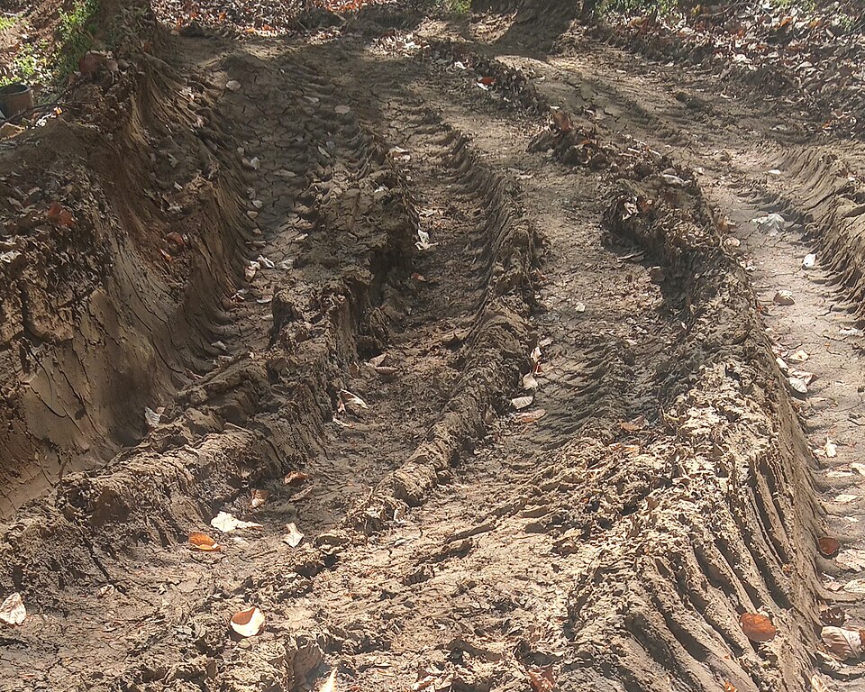
The next picture I would like to put up for a vote is the one below. How would you tag the smoothness of this track?
intermediate(wheels) city bike, sport cars, wheel chair, Scooter and all belowbad(robust_wheels) trekking bike, normal cars, Rickshaw and all belowvery_bad(high_clearance) Car with high clearance, light-duty off road vehicleshorrible(off_road_wheels) heavy-duty off road vehicles and all below
0
voters
Background: see the discussion here. Please read that discussion, add to it if you can, and then vote here. The issue basically is: should “Usable by” in the column header of the wiki table be interpreted as “comfortably usable” or “just passable” (or something in between…)?
FYI the photo has been used in the past to illustrate smoothness=very_bad, but in my opinion shows no obstacles for which high clearance would be an advantage.
Hello, i really like this page and I think it is right overall. One thing i want to discuss are the unhewn_cobblestone examples. This picture in Trinidad looks right in very_bad. But this picture with yellow rocks doesn’t seem right in very_bad. Very_bad unhewn_cobblestone should be passable by average bicyclists with some caution on low speed, but those yellow rocks look like you need a mountainbike and excellent driver skill to pass those passage. Therefore this track should be tagged as horrible or maybe very_horrible. This example should be tagged as horrible too, because those gaps between the stones don’t look easy either.
Here is an example of a track where I think very_bad and unhewn_cobblestone is suitable:
I can drive about 10km/h there with a Trekking bike and this track is already extremely exhausting. Also, you need to look where to drive because there are some sharp edges where you could loose your balance otherwise, so I think very_bad is ok here.
Driver skill is a thing that is not considered or discussed now. A good driver could drive the same track with a Trekking bike instead of a mountain bike and he can find a fast way through a road with many obstacles like mud and potholes. Therefore i often see smoothness discussions like: “I hear people don’t like this road with their Pedelec on full speed, it is horrible”, despite they don’t know how good roads are in Germany on an international spectrum. That is a main problem when people discuss smoothness, because the general wiki guidelines (city bike, trekking bike) can be interpreted this or that way and driver skill is not explained explicitly in smoothness definition (categories like: tourist bicyclist, average bicyclist, expert bicyclist would definitely help).
I would also encourage to exchange some photos. We need photos that focus on the details in the bottom part and show the full street in the upper side of the photo. This is also needed to see gaps and height differences on the street in the detailed bottom part of the photo (some centimeter matter a lot).
Some picture don’t meet that criteria and are therefore more vague and we have discussions that a track looks better than it really feels on the bicycle.
2 Likes
The smoothness key has always been rather car-centric. The very_bad category has been defined early in the development of the tag as “needs high clearance”, i.e. it is so uneven that using a normal car, there is a high risk that an obstacle on the road hits the bottom of the car and you need a car with higher than usual clearance to avoid it. I think the “Trinidad” picture you linked to does not show such obstacles and should be moved to the bad category. The other two pictures do show higher obstacles, but not so high that you need a “heavy-duty off road vehicle”. The picture in your post doesn’t show obstacles that could hit the bottom of a normal car either, so I would tag it with smoothness=bad.
Applying smoothness to 2-wheeled vehicles with narrower tires than cars, some surfaces are more difficult to ride on than they would be with a car. We discussed such a surface above and I think your example is another one that is especially rough for bicycles because of the narrow gaps between the stones that are a perfect trap for bicycle wheels. Maybe cyclists (and bicycle routing apps) should learn to expect that the combination of surface=unhewn_cobblestone + smoothness=bad is going to be particularly bad (i.e. very_bad) for them? Or should we tag it with bicycle:smoothness=very_bad?
2 Likes
I don’t think this is the case, the mapper who introduced it had a portal for cycling, and was a cyclist, IMHO the scale was created with racing bikes in mind (i.e. narrow low profile tyres).
1 Like
First on, as dieterdreist mentioned, smoothness is not car exclusive and there are often ways where cars are not even allowed (paths, designated cycleways)
Despite potholes (which are rare on regular roads here) the smoothness in Germany is somehow mapped as how people feel it and how much the surface slows you which feels kinda right if you want to get something out of this tag. Speed reduction is also a part in this translated table
The picture which I posted is a designated cycleway. The surface slows you by 50% which is enough to worsen the smoothness and some tourist bicyclist dismount their bike on this part or they drive another route to avoid this part.
The road part that i posted was never built for vehicles, it has been built for people to walk on it. I don’t know if people ever felt how bad unhewn cobblestone can be to drive on, it is regularly worse than some average surface=ground farmland tracks.
You have to get a comaprison between different surfaces. This picture is considered very bad, but to be honest it looks very easy to drive on, a walk in the park.
We need consistency between the different surfaces, otherwise smoothness says nothing to someone that wants to find a easy way. It is no solution to say (unhewn_cobblestone + smoothness= bad) is worse than (sett+smoothness=bad), because it may not even be true. A sett road can also have height differences and big gaps, so who knows in the end, only the smoothness tag can give you additional information and it is the reason why we use it.
1 Like
You bring up some cases where clearly the tag doesn’t work well considering both skinny tire & fatter tire vehicles. For these edge cases clearly the surface has to be considered for a skinny tire bike. Regardless of what the original inventor of this tag had in mind, I think it is used mostly with 4 wheel vehicle or motorcycle in mind. For me, if I could drive it with a passenger car its ‘bad’ or better. If I need some clearance (RAV4) and can ride it with a 200+ kg ‘adventure’ motorcycle it’s very_bad. If I need higher clearance (Jeep), or a 150kg dual sport motorcycle, it’s horrible. I ride bikes too but I don’t use that as a metric for smoothness.
This one:
This picture in Trinidad
I would tag as ‘bad’ because it’s obviously OK for a regular passenger car.
This one ‘horrible’ may be better because some of those rocks may have gaps which would require very high clearance.
this picture with yellow rocks
This example
I think very_bad is very appropriate because would be easy with a high clearance vehicle or with an ‘adventure’ motorcycle.
1 Like
No it has not. Even original Proposal:Smoothness talks primarily of “racing bikes, wheel chairs, skates” before even mentioning “sports cars”.
1 Like
I should have phrased that more clearly: the smoother categories are quite neutral concerning vehicles, but for the very_bad category, clearance is mentioned as a discerning property, which I think only applies to 4-wheeled vehicles. The horrible category description has long linked to the Wikipedia article on Off-road vehicles that is mostly about 2-track vehicles and only briefly mentions off road motorbikes. Only the very_horrible category description again mentions trial motor bikes and mountain bikes.
@monotar I agree that the surface and smoothness keys should be independent of each other: smoothness should only depend on how rough the surface is as experienced by wheeled vehicles, independent of the surface value. Unfortunately, there are some surfaces that create different experiences for different wheeled vehicles, and the one you posted is a fine example.
I think smoothness should also be independent of the kind of highway. So if a surface creates different experiences for different “test vehicles” (see above), we should choose one “primary test vehicle” for which we tag the smoothness experience (independent of the highway value). I think at least for the less smooth smoothness values, that should be a 2-track vehicle (i.e. a car). For ways that are too narrow for a 2-tracked vehicle, we should imagine what it would be like to use it with a car, assuming it would be wide enough. For the cycleway you posted, I think we should imagine what kind of car would be needed to drive it if it was wide enough. It seems to me that there are no obstacles for which high clearance is needed, so it can be driven with a normal car (though slowly) and thus smoothness=bad. We can then imagine what kind of bicycle would be needed to ride on it, and then tag it with bicycle:smoothness=very_bad in addition.
Smoothness creates allways different experiences for different “test vehicles”
The name of the tag sounds like “driving experience” but the description of the tag mixes “navigability of different vehicles” with “driving experience”.
1 Like
For those following here it seems to discussion about smoothness had continued in another thread: Revision of Smoothness Gallery
So people following this thread you may want to take a look there too.
5 Likes
I propose to add File:Forest road damaged by truck traffic.jpg - OpenStreetMap Wiki
.JPG)
to
very_horrible dirt and earth
current image at Key:smoothness/Gallery - OpenStreetMap Wiki is rather mud, not dirt and earth
idea is from User:Rhhsmits/SmoothnessGallery - OpenStreetMap Wiki (note, other changes proposed there were discussed in Revision of Smoothness Gallery ) - here I am proposing to apply solely this one
BTW, this looks passable by "heavy-duty off road vehicles " to me but also very_horrible at Key:smoothness - OpenStreetMap Wiki looks passable by them to me
4 Likes
I’m fairly confident that a high-clearance 2WD pickup could make it through in dry conditions (smoothness=very_bad), but if it’s usually muddy, I’d go with smoothness=horrible.