Hi, fellow mappers.
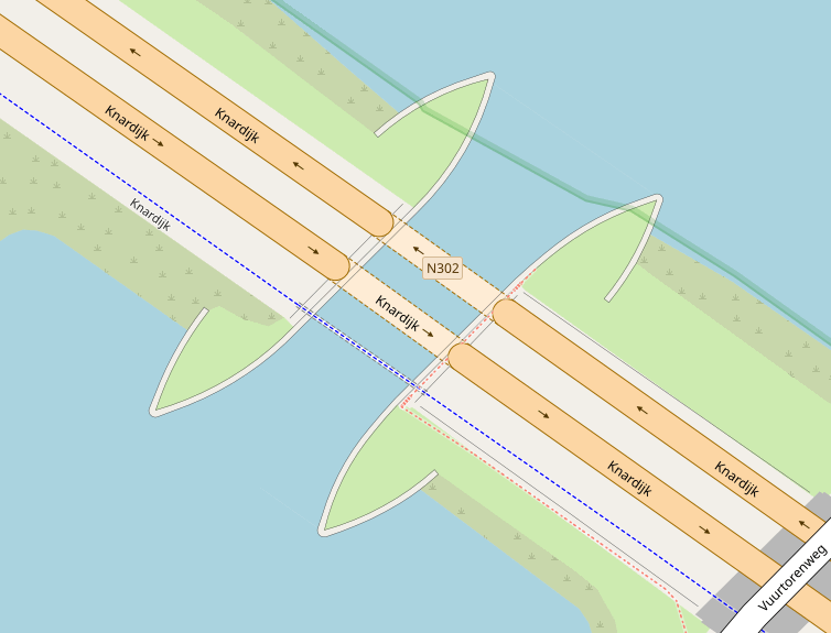
How would you map a river flowing in a bridge above a highway such as this particular example?
Would you do it in an other way?
Hi, fellow mappers.
How would you map a river flowing in a bridge above a highway such as this particular example?
Would you do it in an other way?
Hello Pan,
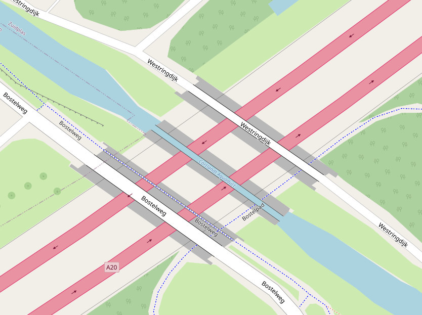
There seems to be two ways of mapping aqueducts, ether by making the road underneath a tunnel and adding natural=water+name=* on top. Without a man_made=bridge:
Or man_made=bridge + waterway=+bridge=
The problem is that natural=water does not render above man_made=bridge:
https://www.openstreetmap.org/way/638876602
This is an aqueduct, rather than just a bridge, so the tagging of the part carrying the water should be tagged as bridge=aqueduct.
Thank you. This is what I did, I think. The problem, then, is in the renderer, I guess.
The problem is that if you want to render natural=water above man_made=bridge that many other bridges won’t look right. However, I do recommend that you add an natual=water area with the correct layer=
I am not sure I understand. The reverbank is a rather large relation. Do you suggest applying the layer tag top the complete relation?
I mean that a waterway has a line:
https://www.openstreetmap.org/way/32485988
and an area:
https://www.openstreetmap.org/way/44866444
I would recommend where the bridge start to have a waterway line with bridge=aqueduct + layer=
https://www.openstreetmap.org/way/39979931
and an area of natural=water+layer= :
https://www.openstreetmap.org/way/638876602
to represent the area of water inside the bridge
I would do only at the bridge
Thanks, I just tried something as per your advice.
It’s not a bridge, it’s an aqueduct. Same word in french.
If you tag as bridge=aqueduct the water will render above the road, for example https://www.openstreetmap.org/#map=18/52.69425/-2.18957
Thanks. I had both tags (man_made=bridge and bridge=aqueduct). I removed the first one.
If you really, really really insist on having your water mapped as an area at layer 1 and rendered, take the bridge area away. Fear though then the roads below will wade through. (try-al and error ;P)
The main reason I map bridge areas is because a bridge with mapped sidewalks, cycleway, north and southbound separated by double guardrails and suspension cables looks ludicrous over land and water.
(an engineering marvel how this one was constructed, sadly never found a fast forward image compilation, if it was ever made.)