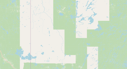
Hello, I am looking to make an app using openstreetmap… however, some parts of the map are getting these giant white/green boundary lines that look like giant pixels - ugly and not suitable for my audience. Is there a way to get rid of these / smooth them out? What do green and white represent?
The forest has not been mapped in the blank places. Either at the time someone was editing there was no good aerial imagery to map them, or the forest was imported from a government dataset, partially.
This is usually a problem of coutries with big unpopulated areas and dense forest cover.
Realistically you can’t do much about this in short term; OSM is a volunteer project and if someone wanted to fix this, they would already. Your best bet would be choosing a map style that just doesn’t display forests, but I don’t think any free options are suitable; in principle you could use Mapbox and customize their Streets style by removing the layer with forests.
FYI, on osm.org if you zoom enough you can query objects by clicking right mouse button on the map. Preferably on the edge of a polygon. From there it’s easy to see object history.
Edit: Bingo, this is Canada: OpenStreetMap
As I expected, it’s a partial CanVec (government maps) import. Maybe ask on the Canada forum Canada - OpenStreetMap Community Forum bearing in mind there’s no way you’re the first one noticing this
Kind of counterintuitively, the way to “use” OpenStreetMap often isn’t to actually use the map tiles that you see on the OpenStreetMap web site. OpenStreetMap is primarily a database, that then various data consumers can use to display whatever kind of map they want, with whatever features and coloring and whatever that makes sense for the audience.
You probably want to use some sort of already-existing library in your app, that takes the data but lets you configure what exactly you want the users to see. You might want to look at the information at Switch2OSM; while a lot of description is for if you were trying to switch to it from some other map data provider, I think a lot of it would make sense for describing if you were starting from scratch, too.
There’s also some information on the wiki that might be helpful:
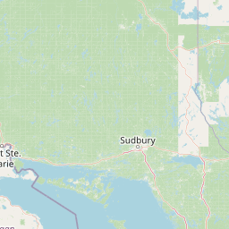
A different, but also related to the tile nature of CanVec data, is the render bug that greatly exaggerates the gaps between forest rectangles. See for instance tile 6/17/22
(upscaled:)
although I believe this is not what you are looking for. Another option would be to simly close the gaps by mapping the landcover there - this will surely take some time but would do a great job anyhow
The problem here, @e2e5 is that “filling in” these gaps is an immense work because its not just about adding some green. You have to consider all the lakes and actual gaps in the forestcover when doing it. Even if doing a very rough fill-in job, its still a lot of work due to the size of these areas. Same thing in other parts of the world (see links below).
If the problem is specifically to the area you have in your picture, its probably fixable by someone spending a day on it, but… as for the whole of canada:
The green area on map in Canada mean forest while the white area mean unmapped of landcover, majority of natural feature in Canada is CanVec (government maps) import
The only proper way to solve your question is continue importing CanVec data and it may need to recruit more mapper to complete this effort
